Country:
 USA
USARegion:
City:
Latitude and Longitude:
Time Zone:
Postal Code:
IP information under different IP Channel
ip-api
Country
Region
City
ASN
Time Zone
ISP
Blacklist
Proxy
Latitude
Longitude
Postal
Route
IPinfo
Country
Region
City
ASN
Time Zone
ISP
Blacklist
Proxy
Latitude
Longitude
Postal
Route
MaxMind
Country
Region
City
ASN
Time Zone
ISP
Blacklist
Proxy
Latitude
Longitude
Postal
Route
Luminati
Country
USASN
Time Zone
America/Chicago
ISP
HSBC Bank plc
Latitude
Longitude
Postal
db-ip
Country
Region
City
ASN
Time Zone
ISP
Blacklist
Proxy
Latitude
Longitude
Postal
Route
ipdata
Country
Region
City
ASN
Time Zone
ISP
Blacklist
Proxy
Latitude
Longitude
Postal
Route
Popular places and events near this IP address

Palatine, Illinois
Village in Illinois, United States
Distance: Approx. 4065 meters
Latitude and longitude: 42.11694444,-88.04055556
Palatine () is a village in Cook County, Illinois, United States. It is a northwestern residential suburb of Chicago. As of the 2020 census, it had a population of 67,908.
Brown's Chicken massacre
1993 mass murder in Palatine, Illinois, USA
Distance: Approx. 4336 meters
Latitude and longitude: 42.12277778,-88.04805556
The Brown's Chicken massacre was a mass murder that occurred on January 8, 1993, in Palatine, Illinois, when two robbers shot and killed seven employees at a Brown's Chicken fast-food restaurant. The case remained unsolved for nearly nine years, until one of the assailants was implicated by his girlfriend in 2002. Police used DNA samples from the murder scene to match one of the suspects, Juan Luna.
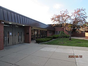
Buffalo Grove High School
Public secondary school in Buffalo Grove, Illinois, United States
Distance: Approx. 1393 meters
Latitude and longitude: 42.1405,-87.9829
Buffalo Grove High School (BGHS) is a public high school located in Buffalo Grove, Illinois, a northwestern suburb of Chicago. It is one of six four-year comprehensive high schools in Township High School District 214, serving portions of the villages of Buffalo Grove, Arlington Heights, and Wheeling. Feeder schools are Cooper Middle School, Thomas Middle School, and London Middle School.
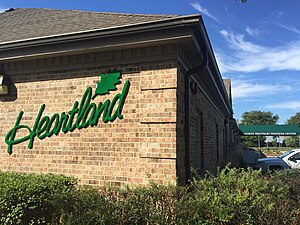
Heartland Institute
Conservative and libertarian American think tank
Distance: Approx. 1308 meters
Latitude and longitude: 42.14738889,-88.00405556
The Heartland Institute is an American conservative and libertarian 501(c)(3) nonprofit public policy think tank known for denying the scientific consensus on climate change and the negative health impacts of smoking. Founded in 1984, it worked with tobacco company Philip Morris throughout the 1990s to attempt to discredit the health risks of secondhand smoke and lobby against smoking bans.: 233–234 Since the 2000s, the Heartland Institute has been a leading promoter of climate change denial.
WPPN
Radio station in Des Plaines, Illinois
Distance: Approx. 1307 meters
Latitude and longitude: 42.137,-87.983
WPPN (106.7 FM) is a radio station licensed to Des Plaines, Illinois, that targets the Chicago metropolitan area. WPPN broadcasts a Spanish AC format. WPPN is owned by TelevisaUnivision through its Uforia Audio Network subsidiary.

WCPY
Polish radio station in Arlington Heights–Chicago, Illinois
Distance: Approx. 1349 meters
Latitude and longitude: 42.137091,-87.982496
WCPY (92.7 FM) is a radio station licensed to Arlington Heights, Illinois, and serving the Chicago area. WCPY airs a Polish language format during the daytime, as "Polski FM", while airing a dance hits format at night known as "Dance Factory FM". Studios are located on Chicago's Northwest Side.
Quest Academy (Palatine, Illinois)
Private school
Distance: Approx. 3977 meters
Latitude and longitude: 42.12,-88.04166667
Quest Academy is an independent school for intellectually gifted students located in Palatine, Illinois. The school is accredited by the Independent Schools Association of the Central States, and it is a member of the National Association of Independent Schools and the National Association for Gifted Children. There are two classes per grade.

Cutting Hall
Distance: Approx. 4231 meters
Latitude and longitude: 42.1134,-88.0397
Cutting Hall Performing Arts Center is a theater in Palatine, Illinois, which was once the auditorium to Palatine High School. It was built in 1927 in honor of Mr. Charles S. Cutting, the principal of Palatine High School.
Raupp Museum
Distance: Approx. 4102 meters
Latitude and longitude: 42.1698,-87.9781
The Raupp Memorial Museum is an organization that chronicles the social history of Buffalo Grove, Illinois. It is part of the Buffalo Grove Park District and an award-winning member of the Illinois Association of Museums.
Chicago Futabakai Japanese School
Private 1-9 school in Arlington Heights, Illinois, United States
Distance: Approx. 2194 meters
Latitude and longitude: 42.121423,-87.981362
Chicago Futabakai Japanese School (シカゴ双葉会日本語学校, Shikago Futabakai Nihongo Gakkō, CFJS; "Futabakai" means "two leaves" or "bud" organization, or "organization of growing sprouts"), alternately in Japanese Shikago Nihonjin Gakkō (シカゴ日本人学校, Chicago Japanese person School), is a Japanese elementary and junior high day school and Saturday education program in Arlington Heights, Illinois near Chicago. As of 1988 it is sponsored by the Japanese Ministry of Education, now the Ministry of Education, Culture, Sports, Science and Technology (MEXT). Before moving to Arlington Heights in 1998, the Futabakai education program was previously located in Chicago, Skokie, and Niles in Illinois, with the day program beginning during the period in Skokie.

Lake Arlington (Illinois)
Human-made lake, detention lake in Arlington Heights, Illinois
Distance: Approx. 4059 meters
Latitude and longitude: 42.11472222,-87.95916667
Lake Arlington is a human-made, 50-acre (20 ha) detention lake in the Chicago suburb of Arlington Heights, Illinois. The lake's average depth is between 5 and 7 feet (1.5 and 2.1 m).
WCLR (Arlington Heights, Illinois)
Radio station in Arlington Heights, Illinois (2003–2017)
Distance: Approx. 2961 meters
Latitude and longitude: 42.1125,-87.98277778
WCLR was a radio station that broadcast on 88.3 FM in Arlington Heights, Illinois. It was owned by the Educational Media Foundation and broadcast its Air1 Contemporary Christian network. Throughout its existence, WCLR shared the 88.3 frequency with Palatine-based WHCM at William Rainey Harper College, broadcasting on weekends and when the college was not in session.
Weather in this IP's area
few clouds
15 Celsius
14 Celsius
13 Celsius
16 Celsius
1023 hPa
79 %
1023 hPa
996 hPa
10000 meters
2.57 m/s
100 degree
20 %
06:53:44
18:26:30