Country:
 Great Britain
Region:
City:
Latitude and Longitude:
Time Zone:
Postal Code:
IP information under different IP Channel
ip-api
Country
Region
City
ASN
Time Zone
ISP
Blacklist
Proxy
Latitude
Longitude
Postal
Route
IPinfo
Country
Region
City
ASN
Time Zone
ISP
Blacklist
Proxy
Latitude
Longitude
Postal
Route
MaxMind
Country
Region
City
ASN
Time Zone
ISP
Blacklist
Proxy
Latitude
Longitude
Postal
Route
Luminati
Country
 US
USASN
Time Zone
America/Chicago
ISP
HSBC Bank plc
Latitude
Longitude
Postal
db-ip
Country
Region
City
ASN
Time Zone
ISP
Blacklist
Proxy
Latitude
Longitude
Postal
Route
ipdata
Country
Region
City
ASN
Time Zone
ISP
Blacklist
Proxy
Latitude
Longitude
Postal
Route
Popular places and events near this IP address

Sheffield
City in South Yorkshire, England
Distance: Approx. 32 meters
Latitude and longitude: 53.38083333,-1.47027778
Sheffield is a city in South Yorkshire, England, whose name derives from the River Sheaf which runs through it. The city serves as the administrative centre of the City of Sheffield. It is historically part of the West Riding of Yorkshire and some of its southern suburbs were transferred from Derbyshire to the city council.

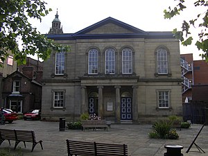
Sheffield Town Hall
Municipal building in Sheffield, South Yorkshire, England
Distance: Approx. 95 meters
Latitude and longitude: 53.3803398,-1.4694321
Sheffield Town Hall is a municipal building on Pinstone Street in the City of Sheffield, England. The building is used by Sheffield City Council, and also contains a publicly displayed collection of silverware. It is a Grade I listed building.
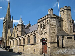
Cathedral Church of St Marie, Sheffield
Church in South Yorkshire, England
Distance: Approx. 127 meters
Latitude and longitude: 53.3813,-1.4682
The Cathedral Church of St Marie is the Roman Catholic cathedral in Sheffield, England. It lies in a slightly hidden location, just off Fargate shopping street, but signals its presence with a 195 feet (59 m) spire, the tallest in Sheffield. It is an especially fine example of an English Roman Catholic Cathedral, with much fine interior decoration.

Company of Cutlers in Hallamshire
United Kingdom legislation
Distance: Approx. 137 meters
Latitude and longitude: 53.3823,-1.46964
The Company of Cutlers in Hallamshire is a trade guild of metalworkers based in Sheffield, England. It was incorporated in 1624 by an act of Parliament. The head is called the Master Cutler.

Orchard Square
Shopping mall in South Yorkshire, England
Distance: Approx. 71 meters
Latitude and longitude: 53.381719,-1.470363
Orchard Square is a small open-air court shopping centre located in Sheffield, England. It opened in 1987 and contains several stores, notably Schuh, Clarks, Waterstone's (with its own instore coffee house), Subway, The Body Shop and TK Maxx (which replaced the original food court). Orchard Square also features Sheffield Creative Guild, La Coupe hair salon, Anne Heppell, Michael Spencer Jewellers, War Games Emporium and Costa.

Diocese of Sheffield
Diocese of the Church of England
Distance: Approx. 100 meters
Latitude and longitude: 53.382,-1.47
The Diocese of Sheffield is an administrative division of the Church of England, part of the Province of York. The Diocese of Sheffield was created under George V on 23 January 1914, by the division from the Diocese of York (along with that part of the Diocese of Southwell in the city of Sheffield). It covers most of the County of South Yorkshire (except Barnsley), with a small part of the East Riding of Yorkshire, one parish in North Yorkshire and one in North Lincolnshire – an area of almost 576 square miles (1,490 km2).

Fargate
Street in Sheffield, England
Distance: Approx. 83 meters
Latitude and longitude: 53.381573,-1.469116
Fargate is a pedestrian precinct and shopping area in Sheffield, England. It runs between Barker's Pool and High Street opposite the cathedral. It was pedestrianised in 1973.

Barker's Pool
Square in Sheffield, England
Distance: Approx. 113 meters
Latitude and longitude: 53.38052778,-1.4715
Barker's Pool is a public city square and street in the centre of Sheffield, England. The focus of Barker's Pool is the Grade II* listed 90-foot-tall (27 m) war memorial that was unveiled on 28 October 1925 to commemorate the First World War. The Grade II* listed Sheffield City Hall is on the north side of the plaza facing the Grade II listed former John Lewis & Partners department store.
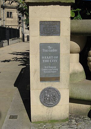
Heart of the City, Sheffield
Area in Sheffield, England
Distance: Approx. 111 meters
Latitude and longitude: 53.3801,-1.4701
The Heart of the City was a £130 million major re-development in Sheffield, England begun in 2004, and completed in 2016 and one of the 12 official quarters of Sheffield City Centre. As its name suggests the Heart of the City is located in the heart of the city centre. Heart of the City was mainly developed by Sheffield One, an Urban Regeneration Company set up in February 2000 to facilitate the redevelopment.
Upper Chapel
Unitarian chapel in Sheffield, South Yorkshire
Distance: Approx. 123 meters
Latitude and longitude: 53.3808,-1.4683
Upper Chapel is a Unitarian chapel on Norfolk Street in Sheffield City Centre. It is a member of the General Assembly of Unitarian and Free Christian Churches, the umbrella organisation for British Unitarians. The Chapel is Grade II listed.
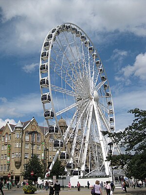
Wheel of Sheffield
Tourist attraction in Sheffield, Yorkshire
Distance: Approx. 17 meters
Latitude and longitude: 53.381,-1.4699
The Wheel of Sheffield was a 60-metre (197 ft) tall transportable Ferris wheel installation on Fargate, by City Hall, in Sheffield, England. It first appeared from July 2009 until November 2010 when it was moved on to London. It opened on 20 July 2009, and was intended to remain until January 2010.
Seven Hills Shul
Distance: Approx. 32 meters
Latitude and longitude: 53.38083333,-1.47027778
Seven Hills Shul (transliteration from Hebrew as "Kehillat Shivah Harim"), is a Reform Jewish community, that worships from rented premises located in Sheffield, South Yorkshire, England, in the United Kingdom. The congregation holds services at a local community centre and also meets in members' houses. Founded in 1989 as Sheffield & District Reform Jewish Congregation, the congregation is a member of the Movement for Reform Judaism.
Weather in this IP's area
clear sky
16 Celsius
15 Celsius
15 Celsius
16 Celsius
1012 hPa
69 %
1012 hPa
1001 hPa
10000 meters
0.45 m/s
1.79 m/s
45 degree
1 %
07:14:57
18:33:12