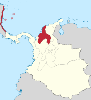
Country:
 Colombia
Region:
City:
Latitude and Longitude:
Time Zone:
Postal Code:
IP information under different IP Channel
ip-api
Country
Region
City
ASN
Time Zone
ISP
Blacklist
Proxy
Latitude
Longitude
Postal
Route
IPinfo
Country
Region
City
ASN
Time Zone
ISP
Blacklist
Proxy
Latitude
Longitude
Postal
Route
MaxMind
Country
Region
City
ASN
Time Zone
ISP
Blacklist
Proxy
Latitude
Longitude
Postal
Route
Luminati
Country
CORegion
dc
City
bogota
ASN
Time Zone
America/Bogota
ISP
COLOMBIA TELECOMUNICACIONES S.A. ESP
Latitude
Longitude
Postal
db-ip
Country
Region
City
ASN
Time Zone
ISP
Blacklist
Proxy
Latitude
Longitude
Postal
Route
ipdata
Country
Region
City
ASN
Time Zone
ISP
Blacklist
Proxy
Latitude
Longitude
Postal
Route
Popular places and events near this IP address

Cartagena, Colombia
City in coastal northern Colombia
Distance: Approx. 1989 meters
Latitude and longitude: 10.4,-75.5
Cartagena ( KAR-tə-HAY-nə), known since the colonial era as Cartagena de Indias (Spanish: [kaɾtaˈxena ðe ˈindjas] ), is a city and one of the major ports on the northern coast of Colombia in the Caribbean Coast Region, along the Caribbean sea. Cartagena's past role as a link in the route to the West Indies provides it with important historical value for world exploration and preservation of heritage from the great commercial maritime routes. As a former Spanish colony, it was a key port for the export of Bolivian silver to Spain and for the import of enslaved Africans under the asiento system.

Bolívar Department
Department of Colombia
Distance: Approx. 1989 meters
Latitude and longitude: 10.4,-75.5
Bolívar (Spanish pronunciation: [boˈliβaɾ]) is a department of Colombia. It was named after one of the original nine states of the United States of Colombia. It is located to the north of the country, extending roughly north–south from the Caribbean coast at Cartagena near the mouth of the Magdalena River, then south along the river to a border with Antioquia Department.

Estadio Jaime Morón León
Distance: Approx. 2144 meters
Latitude and longitude: 10.405534,-75.498237
Estadio Jaime Morón León, formerly known as Estadio Pedro de Heredia, is a multi-use stadium in Cartagena de Indias, Colombia. Built in 1958 it has a capacity of 17,200. It is currently used mostly for football matches as the home venue of Real Cartagena.

Raid on Cartagena de Indias (1697)
French attack during the War of the Grand Alliance
Distance: Approx. 6023 meters
Latitude and longitude: 10.4114,-75.535
The raid on Cartagena de Indias was a successful attack by the French on the fortified city of Cartagena de Indias, on 6 May 1697, as part of the War of the Grand Alliance.

Battle of Cartagena de Indias
1741 naval battle of the War of Jenkins' Ear
Distance: Approx. 6131 meters
Latitude and longitude: 10.38527778,-75.53861111
The Battle of Cartagena de Indias (Spanish: Sitio de Cartagena de Indias, lit. 'Siege of Cartagena de Indias') took place during the 1739 to 1748 War of Jenkins' Ear between Spain and Great Britain. The result of long-standing commercial tensions, the war was primarily fought in the Caribbean; the British tried to capture key Spanish ports in the region, including Porto Bello and Chagres in Panama, Havana, and Cartagena de Indias in present-day Colombia. Two previous naval attacks in 1740 had failed and for the third attempt in March 1741, the British had opted for a combined naval and land attack.
Universidad Tecnológica de Bolívar
Distance: Approx. 3216 meters
Latitude and longitude: 10.3703,-75.4653
The Universidad Tecnológica de Bolívar is an institution of higher education in Colombia. accredited high quality in 2011. In 2015 it was recognized as the third best undergraduate university in the country according to the MIDE. From its foundation in the year of 1970, the university has come outlining like one of the most modern educative centres in the north of Colombia.

Estadio Once de Noviembre
Distance: Approx. 1806 meters
Latitude and longitude: 10.404187,-75.495334
Estadio Once de Noviembre Abel Leal Díaz is a baseball stadium in Cartagena de Indias, Colombia. It currently serves as the home of the Tigres de Cartagena of Colombia's professional baseball league. The stadium has a seating capacity of 12,500 people.
Cartagena Province
1533–1857 province of New Granada
Distance: Approx. 4831 meters
Latitude and longitude: 10.43333333,-75.5
Cartagena Province (Spanish: Provincia de Cartagena), also called Gobierno de Cartagena (Government of Cartagena) during the Spanish imperial era, was an administrative and territorial division of New Granada in the Viceroyalty of Peru. It was originally organized on February 16, 1533 as a captaincy general from the central portion of the Province of Tierra Firme. In 1717, King Philip V of Spain issued a royal decree creating the Viceroyalty of New Granada, by which the province was added to the latter.
Capture of the galleon San Joaquin
1711 naval battle
Distance: Approx. 6023 meters
Latitude and longitude: 10.4114,-75.535
The capture of the galleon San Joaquin or the battle of Cartagena was a naval engagement that took place off the coast near Cartagena (present day Colombia). It involved five British ships of the line against the Spanish galleon San Joaquin and a smaller ship. After an action lasting barely an hour the Spanish ship surrendered.

Convento de la Popa
Distance: Approx. 5461 meters
Latitude and longitude: 10.4192,-75.5255
The convent, cloister and chapel of Nuestra Señora de la Candelaria de la Popa are located at the top of Mount la Popa, in Cartagena de Indias, in Colombia. It is also called Convento de Santa Cruz de la Popa.

Siege of Cartagena (1815)
Part of the Colombian War of Independence
Distance: Approx. 1989 meters
Latitude and longitude: 10.4,-75.5
The Siege of Cartagena (1815) (Spanish: Asedio español de Cartagena de Indias) was a successful 105-day Spanish siege by combined naval and ground forces under command of General Pablo Morillo, of the Colombian city and fortress of Cartagena de Indias, defended by Republican forces under the leadership of Manuel del Castillo y Rada and José Francisco Bermúdez, between August and December 1815.
Siege of Cartagena (1820–21)
Part of the Colombian War of Independence
Distance: Approx. 1989 meters
Latitude and longitude: 10.4,-75.5
The Siege of Cartagena (1820–1821) (Spanish: Asedio de Cartagena de Indias (1820–1821)) was a military confrontation fought in the context of the Colombian War of Independence between Patriots and Royalists, with the victory of the former. It was the longest siege experienced by the city in its history.
Weather in this IP's area
scattered clouds
28 Celsius
34 Celsius
28 Celsius
28 Celsius
1007 hPa
82 %
1007 hPa
1006 hPa
10000 meters
2.75 m/s
3.64 m/s
22 degree
32 %
05:51:24
18:00:32