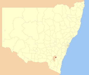
Country:
 Australia
Region:
City:
Latitude and Longitude:
Time Zone:
Postal Code:
IP information under different IP Channel
ip-api
Country
Region
City
ASN
Time Zone
ISP
Blacklist
Proxy
Latitude
Longitude
Postal
Route
IPinfo
Country
Region
City
ASN
Time Zone
ISP
Blacklist
Proxy
Latitude
Longitude
Postal
Route
MaxMind
Country
Region
City
ASN
Time Zone
ISP
Blacklist
Proxy
Latitude
Longitude
Postal
Route
Luminati
Country
AUASN
Time Zone
Australia/Sydney
Latitude
Longitude
Postal
db-ip
Country
Region
City
ASN
Time Zone
ISP
Blacklist
Proxy
Latitude
Longitude
Postal
Route
ipdata
Country
Region
City
ASN
Time Zone
ISP
Blacklist
Proxy
Latitude
Longitude
Postal
Route
Popular places and events near this IP address
City of Queanbeyan
Former local government area in New South Wales, Australia
Distance: Approx. 1704 meters
Latitude and longitude: -35.35,149.21666667
Queanbeyan City was a local government area located in south eastern New South Wales, Australia. The former area is located adjacent to Canberra and the Australian Capital Territory, the Queanbeyan River, the Molonglo River, the Kings Highway and the Sydney-Canberra railway. On 12 May 2016 the Minister for Local Government announced dissolution of Queanbeyan City with immediate effect.
Symonston, Australian Capital Territory
Suburb of Canberra, Australian Capital Territory
Distance: Approx. 1850 meters
Latitude and longitude: -35.34638889,149.17777778
Symonston (postcode: 2609) is a primarily industrial and agricultural suburb of Canberra, Australian Capital Territory, Australia. Symonston is named after Sir Josiah Symon a Legislator, Federalist and one of the Founders of the Constitution of Australia. Located in Symonston are the Periodic Detention Centre and Symonston Temporary Remand Centre and three caravan parks: Canberra South Motor Park, Sundown Village and Narrabundah Longstay Caravan Park.
HMAS Harman
Royal Australian Navy base
Distance: Approx. 342 meters
Latitude and longitude: -35.34666667,149.20111111
HMAS Harman is a Royal Australian Navy (RAN) base that serves as a communications and logistics facility. The main base is located in the Australian capital of Canberra, and is geographically recognised as the suburb of Harman (postcode 2600) in the District of Jerrabomberra. Established in the late 1930s as the Royal Australian Navy Wireless/Transmitting Station Canberra, the facility was commissioned into the RAN as a stone frigate in 1943.
Jerrabomberra, New South Wales
Suburb of Queanbeyan, New South Wales, Australia
Distance: Approx. 2042 meters
Latitude and longitude: -35.36666667,149.2
Jerrabomberra is a suburb of Queanbeyan in south eastern New South Wales, Australia. Jerrabomberra consists of three sections, The Park, The Heights, and Lakeview. The Park and the Heights are divided by Edwin Land Parkway.

Queanbeyan railway station
Railway station in New South Wales, Australia
Distance: Approx. 2706 meters
Latitude and longitude: -35.3428,149.227
Queanbeyan railway station is a heritage-listed railway station located on the Bombala line in New South Wales, Australia. It serves the town of Queanbeyan.
Queanbeyan High School
School in Australia
Distance: Approx. 2197 meters
Latitude and longitude: -35.3531,149.2215
Queanbeyan High School is a government-funded co-educational comprehensive secondary day school, located in Queanbeyan, in the Southern Tablelands region of New South Wales, Australia. Established in 1959, the school enrolled approximately 500 students in 2018, from Year 7 to Year 12, of whom 13 per cent identified as Indigenous Australians and 22 per cent from a language background other than English. The school is operated by the NSW Department of Education; the principal is Jennifer Green.

Canberra Outlet Centre
Shopping mall in Fyshwick, Australian Capital Territory
Distance: Approx. 2208 meters
Latitude and longitude: -35.3366,149.17846
Canberra Outlet Centre (formerly known as DFO Canberra and Homemaker Hub and Direct Factory Outlets Canberra) is an outlet type discount shopping centre located on the edge of Fyshwick, a light industrial suburb located in the southeast of Canberra. In addition to providing retail space for 100 specialty outlet stores, the Homewares/Furniture section of the centre is designed for 24 bulky goods retailers, such as furniture and electrical chains. Unlike many other outlet centres, the Canberra site is not adjacent to an airport.

Queanbeyan West
Suburb of Queanbeyan, New South Wales, Australia
Distance: Approx. 1399 meters
Latitude and longitude: -35.3572,149.209
Queanbeyan West is a suburb of Queanbeyan, New South Wales, Australia. Queanbeyan West is located west of the central business district (CBD) and also borders the Australian Capital Territory, it is located south of Crestwood and Canberra Avenue and west of Tharwa Road. At the 2021 census, it had a population of 3,146.
Crestwood, Queanbeyan
Suburb of Queanbeyan, New South Wales, Australia
Distance: Approx. 1643 meters
Latitude and longitude: -35.34832,149.21609
Crestwood is a suburb of Queanbeyan, New South Wales, Australia. Crestwood is located west of the central business district (CBD) to the west of Ross Road and the north of Canberra Avenue and also borders the Australian Capital Territory. At the 2021 census, it had a population of 4,936.

Beard, Australian Capital Territory
Suburb of Canberra, Australian Capital Territory
Distance: Approx. 1346 meters
Latitude and longitude: -35.3413,149.21
Beard is a suburb of Canberra in the District of Jerrabomberra, Australian Capital Territory, named after ex-convict Timothy Beard, the first recorded European settler in the vicinity of modern-day Queanbeyan.
Jerrabomberra (district)
Place in Australian Capital Territory
Distance: Approx. 1850 meters
Latitude and longitude: -35.34638889,149.17777778
Jerrabomberra is a district in the Australian Capital Territory in Australia. It is situated to the southeast of Canberra Central, south of the Molonglo River, east of Woden Valley and north east of Tuggeranong and west of the New South Wales border. It includes the suburbs of Beard, Hume, Oaks Estate and Symonston and the military communications and logistics facility HMAS Harman.
Letchworth railway station, New South Wales
Former railway station in New South Wales, Australia
Distance: Approx. 2446 meters
Latitude and longitude: -35.3695,149.1905
Letchworth is a former railway station that was located on the Bombala railway line. It was named Letchworth, after Letchworth Garden City. The name was suggested by land developer H. F. Halloran.
Weather in this IP's area
scattered clouds
3 Celsius
3 Celsius
1 Celsius
4 Celsius
1028 hPa
89 %
1028 hPa
957 hPa
10000 meters
40 %
06:00:10
17:55:32