Country:
 Switzerland
Region:
City:
Latitude and Longitude:
Time Zone:
Postal Code:
IP information under different IP Channel
ip-api
Country
Region
City
ASN
Time Zone
ISP
Blacklist
Proxy
Latitude
Longitude
Postal
Route
IPinfo
Country
Region
City
ASN
Time Zone
ISP
Blacklist
Proxy
Latitude
Longitude
Postal
Route
MaxMind
Country
Region
City
ASN
Time Zone
ISP
Blacklist
Proxy
Latitude
Longitude
Postal
Route
Luminati
Country
CHASN
Time Zone
Europe/Zurich
ISP
Bluewin
Latitude
Longitude
Postal
db-ip
Country
Region
City
ASN
Time Zone
ISP
Blacklist
Proxy
Latitude
Longitude
Postal
Route
ipdata
Country
Region
City
ASN
Time Zone
ISP
Blacklist
Proxy
Latitude
Longitude
Postal
Route
Popular places and events near this IP address
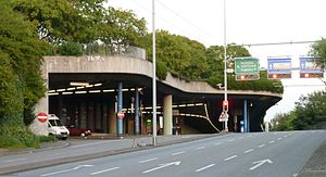
Milchbuck Tunnel
Distance: Approx. 360 meters
Latitude and longitude: 47.3853,8.5369
The Milchbuck Tunnel is a motor road tunnel in Switzerland, and forms part of the A1L motorway from Zürich Schwamendingen to Zürich Letten, where the tunnel's southern portal lies on Wasserwerkstrasse, which leads into central Zürich. Constructed in 1978, the tunnel is 1,910 metres (6,270 ft) in length. A proposed second tunnel bore (to create two separate tunnels for two directions of traffic) was turned down.

Sihl
River in Switzerland
Distance: Approx. 289 meters
Latitude and longitude: 47.3826,8.5382
The Sihl is a Swiss river that rises near the Druesberg mountain in the canton of Schwyz, and eventually flows into the Limmat in the centre of the city of Zürich, after crossing the Zürich–Winterthur railway at Zürich HB. It has a length of 73 km (45 mi), including the Sihlsee reservoir, through which the river flows. Water is abstracted from the river at the Sihlsee, leading to decreased downstream water flows and a consequent reduction in water quality. The river flows through, or along the border of, the cantons of Schwyz, Zürich and Zug.

Oberstrass
Distance: Approx. 535 meters
Latitude and longitude: 47.38433611,8.548425
Oberstrass is a quarter in the district 6 in Zürich. It was formerly a municipality of its own, having been incorporated into Zürich in 1893. The quarter has a population of 9,494 distributed on an area of 2.64 km2 (1.02 sq mi).
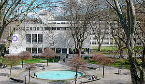
Museum of Design, Zürich
Museum in Zurich (Switzerland)
Distance: Approx. 401 meters
Latitude and longitude: 47.382798,8.536366
The Museum of Design, Zürich (German: Museum für Gestaltung Zürich) is a museum for industrial design, visual communication, architecture, and craft in Zurich, Switzerland.

A.V. Turicia
Swiss student association
Distance: Approx. 243 meters
Latitude and longitude: 47.38527778,8.53861111
AV Turicia is a color-bearing student society in Zürich. It was founded in 1860. It is a section of the Swiss Student Association and a member of the "Federation of Student Komment Societies" (also known as "Block").

Platzspitz park
Distance: Approx. 383 meters
Latitude and longitude: 47.38083333,8.53972222
The Platzspitz park is a park in Zürich, Switzerland. It is located next to the Swiss National Museum and Zürich Hauptbahnhof.

Zurich University of the Arts
Art school in Zürich, Switzerland
Distance: Approx. 459 meters
Latitude and longitude: 47.38277778,8.53555556
Zurich University of the Arts (ZHdK, ‹See Tfd›German: Zürcher Hochschule der Künste) has approximately 2,500 students, which makes it the largest arts university in Switzerland. The university was established in 2007, following the merger between Zurich's School of Art and Design (HGKZ) and the School of Music, Drama, and Dance (HMT). ZHdK is one of four universities affiliated with Zürcher Fachhochschule.

Weinberg Tunnel
Railway tunnel in Zürich, Switzerland
Distance: Approx. 542 meters
Latitude and longitude: 47.38852778,8.54433333
The Weinberg Tunnel (‹See Tfd›German: Weinbergtunnel) is a railway tunnel in the Swiss city of Zürich. The tunnel runs from the western approaches to Zürich Hauptbahnhof railway station, east under the station and city centre before turning north and surfacing on the southern approach to Zürich Oerlikon railway station, and allows trains running between east and west to pass through Zürich without reversal. It includes a new set of underground platforms at Zürich Hauptbahnhof, and carries twin standard gauge (1,435 mm or 4 ft 8+1⁄2 in) tracks electrified at 15 kV AC 16 2/3 Hz using overhead catenary.
Drosos Foundation
Non-profit, charitable organization based in Zürich, Switzerland
Distance: Approx. 156 meters
Latitude and longitude: 47.3829,8.5424
The Drosos Foundation (‹See Tfd›German: Drosos Stiftung) is a non-profit, charitable organization based in Zürich, Switzerland. Established in late 2003 with capital from a private endowment, the foundation was fully active by early 2005. The foundation is involved with more than 100 projects as of 2015, which work to fight poverty, promote health, increase access to education and creative activities for youth, and protect the environment.

Letten Tunnel
Disused railway tunnel in Zürich
Distance: Approx. 194 meters
Latitude and longitude: 47.3838,8.5388
The Letten Tunnel (‹See Tfd›German: Lettentunnel) is a disused railway tunnel in the Swiss city of Zürich. It is situated on the old route of the Lake Zürich right bank railway (Rechtsufrige Zürichseebahn) from Zurich Hbf station to Rapperswil station. Radical changes to the local railway geography led to the tunnel being superseded in 1990, and closed and sealed by 2002.
Center for Comparative and International Studies
Distance: Approx. 398 meters
Latitude and longitude: 47.3805585,8.5405656
The Center for Comparative and International Studies (CIS) is a political science research institute founded in 1997 and based in Zürich. It is joint initiative between the institute of political science of the University of Zurich and the political science chairs of the Swiss Federal Institute of Technology. The director of the institute is Frank Schimmelfennig, Professor of European Politics.
Swiss School of Public Governance
Distance: Approx. 276 meters
Latitude and longitude: 47.38163791,8.54174646
The Swiss School of Public Governance (SSPG) is a center of teaching and research at the ETH Zurich, focusing on governance and leadership issues in the public sector. Established in 2016, the center operates within the Department of Management, Technology, and Economics at ETH Zurich. It integrates Switzerland's governance expertise with a global outlook and fosters interdisciplinary collaboration with various departments and external institutions, contributing to the advancement of knowledge and practice in governance and leadership.
Weather in this IP's area
overcast clouds
8 Celsius
8 Celsius
7 Celsius
9 Celsius
1018 hPa
94 %
1018 hPa
968 hPa
10000 meters
0.89 m/s
2.24 m/s
5 degree
100 %
07:30:26
18:57:39