160.238.73.108 - IP Lookup: Free IP Address Lookup, Postal Code Lookup, IP Location Lookup, IP ASN, Public IP
Country:
Region:
City:
Location:
Time Zone:
Postal Code:
IP information under different IP Channel
ip-api
Country
Region
City
ASN
Time Zone
ISP
Blacklist
Proxy
Latitude
Longitude
Postal
Route
Luminati
Country
Region
ap
City
visakhapatnam
ASN
Time Zone
Asia/Kolkata
ISP
Andhra Pradesh State FiberNet Limited
Latitude
Longitude
Postal
IPinfo
Country
Region
City
ASN
Time Zone
ISP
Blacklist
Proxy
Latitude
Longitude
Postal
Route
IP2Location
160.238.73.108Country
Region
andhra pradesh
City
pakala
Time Zone
Asia/Kolkata
ISP
Language
User-Agent
Latitude
Longitude
Postal
db-ip
Country
Region
City
ASN
Time Zone
ISP
Blacklist
Proxy
Latitude
Longitude
Postal
Route
ipdata
Country
Region
City
ASN
Time Zone
ISP
Blacklist
Proxy
Latitude
Longitude
Postal
Route
Popular places and events near this IP address
Pakala, Tirupati district
Town in Andhra Pradesh, India
Distance: Approx. 0 meters
Latitude and longitude: 13.4667,79.1167
Pakala is a town in Tirupati district of the Indian state of Andhra Pradesh. It is the mandal headquarters of Pakala mandal. It comes under Tirupati revenue division.
Damalcheruvu
Town in India
Distance: Approx. 7454 meters
Latitude and longitude: 13.48333333,79.05
Damalacheruvu is a town in the Tirupati district of the southern Indian state of Andhra Pradesh.
Yellampalli
Village in Andhra Pradesh, India
Distance: Approx. 3653 meters
Latitude and longitude: 13.4455535,79.1425061
Yellampalli is a village in Annamayya district of Andhra Pradesh in India. It is located between the towns of Kalikiri and Piler.It is a small village with population of around 100. The village is named after the earlier settlers in the village who belonged to Yellam Reddy subcaste of the Reddy caste.

Linganapalle
Village in Andhra Pradesh, India
Distance: Approx. 9451 meters
Latitude and longitude: 13.40014,79.170887
Linganapalle is a village in the state of Andhra Pradesh, India. It lies in Chittoor district, 28 km north of the town of Chittoor. Linganapalle is famous for its mangoes, sugarcane and poultry.

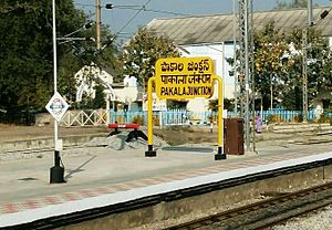
Pakala Junction railway station
Railway Station in Andhra Pradesh
Distance: Approx. 1773 meters
Latitude and longitude: 13.4509,79.1146
Pakala Junction railway station (station code: PAK) is a railway station serving Pakala, Tirupati district, Andhra Pradesh, 517112, India.
Weather in this IP's area
broken clouds
22 Celsius
22 Celsius
22 Celsius
22 Celsius
1010 hPa
90 %
1010 hPa
960 hPa
10000 meters
1.29 m/s
1.25 m/s
337 degree
82 %
