159.83.176.47 - IP Lookup: Free IP Address Lookup, Postal Code Lookup, IP Location Lookup, IP ASN, Public IP
Country:
 USA
USARegion:
City:
Location:
Time Zone:
Postal Code:
ISP:
ASN:
language:
User-Agent:
Proxy IP:
Blacklist:
IP information under different IP Channel
ip-api
Country
Region
City
ASN
Time Zone
ISP
Blacklist
Proxy
Latitude
Longitude
Postal
Route
db-ip
Country
Region
City
ASN
Time Zone
ISP
Blacklist
Proxy
Latitude
Longitude
Postal
Route
IPinfo
Country
Region
City
ASN
Time Zone
ISP
Blacklist
Proxy
Latitude
Longitude
Postal
Route
IP2Location
159.83.176.47Country
usRegion
california
City
los angeles
Time Zone
America/Los_Angeles
ISP
Language
User-Agent
Latitude
Longitude
Postal
ipdata
Country
Region
City
ASN
Time Zone
ISP
Blacklist
Proxy
Latitude
Longitude
Postal
Route
Popular places and events near this IP address
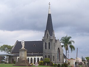
Calvary Cemetery (Los Angeles)
Cemetery located in California, U.S.
Distance: Approx. 1628 meters
Latitude and longitude: 34.02833333,-118.17666667
Calvary Cemetery is a Roman Catholic cemetery that the Archdiocese of Los Angeles runs in the community of East Los Angeles, California. It is also called "New Calvary Cemetery" because it succeeded the original Calvary Cemetery (on north Broadway), over which Cathedral High School was built.

City Terrace, California
Unincorporated community in California, United States
Distance: Approx. 1087 meters
Latitude and longitude: 34.05,-118.18194444
City Terrace is an unincorporated area of East Los Angeles, in Los Angeles County, California, east of Downtown Los Angeles. It contains City Terrace Elementary School, Robert F. Kennedy Elementary School, Esteban Torres High School, Harrison Elementary School, William R. Anton Elementary School, Hammel Street Elementary School, Anthony Quinn Library, City Terrace Library, and City Terrace Park. It is part of the Census-designated place of East Los Angeles.

Evergreen Cemetery (Los Angeles)
Cemetery in Boyle Heights, California
Distance: Approx. 1104 meters
Latitude and longitude: 34.0402899,-118.1978499
Evergreen Memorial Park & Crematory is a cemetery in the East Side neighborhood of Boyle Heights, Los Angeles, California. Evergreen has several prominent individuals of historical Southern California on its grounds. Many pioneers are interred here, names such as Bixby, Coulter, Hollenbeck, Lankershim, Van Nuys, and Workman.

Malabar Branch Library
United States historic place
Distance: Approx. 1454 meters
Latitude and longitude: 34.05055556,-118.19638889
Malabar Branch Library is a branch library of the Los Angeles Public Library located in the Boyle Heights section of Los Angeles, California. The Malabar Branch began in 1914 as a book depository in a Sunday school room at the Brooklyn Heights Methodist Church on the corner of Evergreen Avenue and Malabar Street. The original collection consisted of approximately 900 books that were checked out on the honor system.

Robert Louis Stevenson Branch Library
United States historic place
Distance: Approx. 1787 meters
Latitude and longitude: 34.02777778,-118.19722222
Robert Louis Stevenson Branch Library is a branch library of the Los Angeles Public Library located in the Boyle Heights section of Los Angeles, California. It was built in 1927 based on a Spanish Colonial Revival design by architect George L. Lindsay.

Indiana station (Los Angeles Metro)
Los Angeles Metro Rail station
Distance: Approx. 928 meters
Latitude and longitude: 34.0343,-118.1922
Indiana station is an at-grade light rail station on the E Line of the Los Angeles Metro Rail system. It is located alongside South Indiana Street (the station's namesake) as the line transitions between 1st Street and 3rd Street on the eastern edge of the Boyle Heights neighborhood of Los Angeles. This station opened in 2009 as part of the Gold Line Eastside Extension.

Chinese Cemetery of Los Angeles
Distance: Approx. 1354 meters
Latitude and longitude: 34.03638889,-118.17222222
The Chinese Cemetery of Los Angeles is one of several historical cemeteries found around East Los Angeles, including Evergreen and Calvary cemeteries. Located at First Street and Eastern Avenue in the Belvedere Gardens section of East Los Angeles, today the cemetery is now bordered on the south by the Pomona Freeway (60) and on the east by the Long Beach Freeway (710). The cemetery was established by the Chinese Consolidated Benevolent Association of Los Angeles (CCBA) in 1922 to provide burial grounds for Chinese residents in Los Angeles, as at the time, all cemeteries in Los Angeles barred anyone of Chinese descent from purchasing burial plots.

El Pino (The Pine Tree)
Bunya pine tree in East Los Angeles, California
Distance: Approx. 656 meters
Latitude and longitude: 34.0432,-118.1924
El Pino (English: The Pine Tree) is a large bunya pine located on the southeastern corner of Folsom Street and N. Indiana Street in East Los Angeles, California. The tree overlooks the Wellington Heights neighborhood of East Los Angeles and the Boyle Heights neighborhood of the city of Los Angeles from atop a small hill.
Esteban Torres High School
Public school in Los Angeles, California, United States
Distance: Approx. 968 meters
Latitude and longitude: 34.041817,-118.175483
Esteban Torres High School is a public high school, it opened in 2010 in East Los Angeles, an unincorporated section of Los Angeles County, California.
East Los Angeles Renaissance Academy
Art school in Los Angeles, California
Distance: Approx. 1007 meters
Latitude and longitude: 34.0418075,-118.17504861
East Los Angeles Renaissance Academy (ELARA) Renaissance; officially East Los Angeles Renaissance Academy at Esteban E. Torres High School No. 2, unofficially East Los Angeles Renaissance Academy, School of Urban Planning and Public Policy, is a small public, coeducational, pilot secondary school of the Los Angeles Unified School District (LAUSD) located in East Los Angeles, California. Founded in 2010 as an attempt to relieve student overcrowding at James A. Garfield High School, ELARA is one of five small schools established on the Esteban E. Torres High School campus, alongside East Los Angeles Performing Arts Magnet (ELAPA Magnet), Humanitas Academy of Arts and Technology (HAAT), Social Justice Leadership Academy (SJLA), and Engineering and Technology Academy (ETA).
El Mercado de Los Ángeles
Market in Boyle Heights, California, United States
Distance: Approx. 852 meters
Latitude and longitude: 34.03701,-118.19392
El Mercado de Los Ángeles, sometimes referred to simply as El Mercadito, is a market located in Boyle Heights on the corner of 1st Street and Lorena Street. El Mercado is a three-floor indoor shopping center that offers dining and restaurant services, entertainment with live mariachi bands and shopping from various vendors. The market is located by the Metro E Line's Indiana Station located two blocks east.
El Tepeyac Café
Mexican restaurant in Los Angeles, CA, US
Distance: Approx. 1333 meters
Latitude and longitude: 34.04777778,-118.19763889
El Tepeyac Café, or simply El Tepeyac, is a longstanding Mexican restaurant in the Boyle Heights neighborhood of East Los Angeles. They are famous for their massive burritos, “Manuel’s Special Burrito” and the “Hollenbeck Burrito.” The original location is at 812 North Evergreen Avenue, Los Angeles, CA 90033.
Weather in this IP's area
clear sky
16 Celsius
16 Celsius
15 Celsius
17 Celsius
1019 hPa
76 %
1019 hPa
1004 hPa
10000 meters
5.14 m/s
260 degree