Country:
 Mexico
Region:
City:
Latitude and Longitude:
Time Zone:
Postal Code:
IP information under different IP Channel
ip-api
Country
Region
City
ASN
Time Zone
ISP
Blacklist
Proxy
Latitude
Longitude
Postal
Route
IPinfo
Country
Region
City
ASN
Time Zone
ISP
Blacklist
Proxy
Latitude
Longitude
Postal
Route
MaxMind
Country
Region
City
ASN
Time Zone
ISP
Blacklist
Proxy
Latitude
Longitude
Postal
Route
Luminati
Country
MXRegion
cmx
City
alvaroobregon
ASN
Time Zone
America/Mexico_City
ISP
UNINET
Latitude
Longitude
Postal
db-ip
Country
Region
City
ASN
Time Zone
ISP
Blacklist
Proxy
Latitude
Longitude
Postal
Route
ipdata
Country
Region
City
ASN
Time Zone
ISP
Blacklist
Proxy
Latitude
Longitude
Postal
Route
Popular places and events near this IP address

Veracruz
State of Mexico
Distance: Approx. 3782 meters
Latitude and longitude: 19.52722222,-96.9225
Veracruz (Latin American Spanish: [beɾaˈkɾus] ), formally Veracruz de Ignacio de la Llave (Latin American Spanish: [beɾaˈkɾus ðejɣˈnasjo ðe la ˈʝaβe]), officially the Estado Libre y Soberano de Veracruz de Ignacio de la Llave (English: Free and Sovereign State of Veracruz de Ignacio de la Llave), is one of the 31 states which, along with Mexico City, comprise the 32 Federal Entities of Mexico. Located in eastern Mexico, Veracruz is bordered by seven states, which are Tamaulipas, San Luis Potosí, Hidalgo, Puebla, Oaxaca, Chiapas, and Tabasco. Veracruz is divided into 212 municipalities, and its capital city is Xalapa-Enríquez.

Xalapa
Municipality and city in Veracruz, Mexico
Distance: Approx. 4028 meters
Latitude and longitude: 19.54,-96.9275
Xalapa or Jalapa (English: , Spanish: [xaˈlapa] ), officially Xalapa-Enríquez (IPA: [xaˈlapa enˈrikes]), is the capital city of the Mexican state of Veracruz and the name of the surrounding municipality. In the 2020 census the city reported a population of 443,063 and the municipality of which it serves as municipal seat reported a population of 488,531. The municipality has an area of 118.45 km2.
Roman Catholic Archdiocese of Xalapa
Latin Catholic jurisdiction in Mexico
Distance: Approx. 4028 meters
Latitude and longitude: 19.54,-96.9275
The Archdiocese of Xalapa (Latin: Archidioecesis Ialapensis) is a Latin Church ecclesiastical territory or archdiocese of the Catholic Church in Mexico. Its episcopal see is Xalapa, Veracruz. A metropolitan see, its ecclesiastical province includes the suffragan dioceses of Coatzacoalcos, Córdoba, Orizaba, Papantla, San Andrés Tuxtla, Tuxpan and Veracruz.

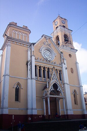
Xalapa Cathedral
Church in Xalapa, Mexico
Distance: Approx. 3811 meters
Latitude and longitude: 19.527688,-96.922994
Xalapa Cathedral or in full, Catedral Metropolitana de la Inmaculada Concepción de Xalapa is a Roman Catholic cathedral in the city of Xalapa, Veracruz, in eastern Mexico. The see of the Metropolitan Archdiocese of Xalapa, it is one of the oldest constructions of the city. The cathedral was originally built in 1641, but in 1772 it underwent massive change that reconstructed it in the baroque style.

El Colegio de Veracruz
College in Xalapa, Veracruz, Mexico
Distance: Approx. 3493 meters
Latitude and longitude: 19.5293,-96.9204
The El Colegio de Veracruz (Colver) is a college in the city of Xalapa, Veracruz, Mexico.
Universidad de Xalapa
University
Distance: Approx. 2473 meters
Latitude and longitude: 19.5191,-96.8811
The Universidad de Xalapa is a university in the city of Xalapa, Veracruz, Mexico. The institution was founded on September 28, 1992, by entrepreneurs Carlos García Méndez, Rubén Pabello Rojas, Carmen Sosa de Pabello and Isabel Soberano de la Cruz as a response to the demand from youngsters with not much career options in the area. It is considered as the pioneer of the private universities in the city which as 2016 includes more than a hundred schools.
Universidad Metropolitana Xalapa
Distance: Approx. 3892 meters
Latitude and longitude: 19.5349,-96.9258
The Universidad Metropolitana Xalapa is a university in the city of Xalapa, Veracruz, Mexico. This university offers 4 year degrees in several courses including: Business Administration, Public Accounting, International Business, Marketing, Industrial Relations, Law, Pedagogy, Architecture, English, and Tourism.
Kaná, Museo de Ciencia y Tecnología
Distance: Approx. 2506 meters
Latitude and longitude: 19.518001,-96.894154
Kaná, Museo de Ciencia y Tecnología, formerly the Museo de Ciencia y Tecnología and then the Museo Interactivo de Xalapa, is a modern interactive museum in the city of Xalapa, capital of the state of Veracruz in eastern Mexico.

Paseo de los Lagos
Distance: Approx. 4147 meters
Latitude and longitude: 19.51888889,-96.92166667
Paseo de los Lagos is a lake and public path located in the city of Xalapa in Veracruz state in eastern Mexico. It was once the site of an ancient dam. The lake has a fresh-water spring and is surrounded by footpaths.
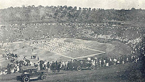
Estadio Xalapeño
Distance: Approx. 3855 meters
Latitude and longitude: 19.51972222,-96.91888889
The Stadium at Xalapa, Veracruz, ("Estadio Xalapeño") is located a few blocks south and downhill of the center of town, and can be easily seen from the terraces of Parque Juárez. The place was identified in the 1920s by William K. Boone, then president of the local Chamber of Commerce, as a natural stadium similar to those of the classical stadiums and theaters of Ancient Greece. The site had been a mosquito-infested marshland known as the "Ciénega de Melgarejo" that was drained and filled under the direction of the Chamber of Commerce, with manpower provided by the Jalapa Railroad and Power Company (JRR&PC).

Parque Juárez
Public park in Xalapa, Mexico
Distance: Approx. 3964 meters
Latitude and longitude: 19.52611111,-96.92388889
Parque Juárez is a public park in the city of Xalapa, in the state of Veracruz in eastern Mexico. It was inaugurated in 1892 and named in honor of Benito Juárez, 20 years after his death. The park is located in central Xalapa with a terrace-like appearance adjoining the Palacio de Gobierno building, across the street from the Palacio Municipal and close to the cathedral.
Parque Los Berros
Distance: Approx. 3444 meters
Latitude and longitude: 19.52361111,-96.91694444
Parque Los Berros, in Xalapa, Veracruz, is located a short distance to the southeast of the center of town, in the neighbourhood of the Stadium. Its name was derived from an edible herb called "berros" (garden cress) that used to grow in the area. Throughout the 19th century, the place would turn into a mosquito-infested marshland during the Summer rainy season.
Weather in this IP's area
light rain
21 Celsius
21 Celsius
21 Celsius
21 Celsius
1012 hPa
95 %
1012 hPa
872 hPa
9057 meters
0.99 m/s
1.17 m/s
125 degree
67 %
06:15:47
18:27:22