Country:
Region:
City:
Latitude and Longitude:
Time Zone:
Postal Code:
IP information under different IP Channel
ip-api
Country
Region
City
ASN
Time Zone
ISP
Blacklist
Proxy
Latitude
Longitude
Postal
Route
Luminati
Country
ASN
Time Zone
America/Chicago
ISP
Electronic Arts Ireland Limited
Latitude
Longitude
Postal
IPinfo
Country
Region
City
ASN
Time Zone
ISP
Blacklist
Proxy
Latitude
Longitude
Postal
Route
db-ip
Country
Region
City
ASN
Time Zone
ISP
Blacklist
Proxy
Latitude
Longitude
Postal
Route
ipdata
Country
Region
City
ASN
Time Zone
ISP
Blacklist
Proxy
Latitude
Longitude
Postal
Route
Popular places and events near this IP address

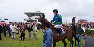
Galway Races
Distance: Approx. 599 meters
Latitude and longitude: 53.29583333,-8.99583333
The Galway Races (Irish: Rásaí na Gaillimhe) is an Irish horse-racing festival that starts on the last Monday of July every year. Held at Ballybrit Racecourse in Galway, Ireland over seven days, it is one of the longest of all the race meets that occur in Ireland. The busiest days of the festival are Wednesday, when the Galway Plate is held, and Thursday, when the Galway Hurdle and Ladies' Day take place.

Doughiska
Townland in Connacht, Ireland
Distance: Approx. 1826 meters
Latitude and longitude: 53.2833,-8.9838
Doughiska (Irish: Dabhach Uisce, meaning 'water basin') is a townland and suburb of Galway City in County Galway, Ireland. There has been continuous urban development between Doughiska and the city centre due to the growth of Galway City in the early 21st century.
Merlin Park University Hospital
Hospital in Galway, Ireland
Distance: Approx. 2450 meters
Latitude and longitude: 53.2775,-8.9927
Merlin Park University Hospital (Irish: Ospidéal Ollscoile Pháirc Mherlin) is a public hospital in Galway, Ireland. It is managed by Saolta University Health Care Group.

Castlegar, County Galway
Village in County Galway, Ireland
Distance: Approx. 1958 meters
Latitude and longitude: 53.3,-9.0185
Castlegar (Irish: An Caisleán Gearr, meaning 'short castle') is a village and electoral division in County Galway, just outside the city of Galway, in Ireland. Castlegar is also an ecclesiastical parish in the Roman Catholic Diocese of Galway, Kilmacduagh and Kilfenora. It extends from Lough Corrib across to Merlin Park by the old Galway-Dublin road.
St James' GAA (Galway)
Gaelic sports club in Galway, Ireland
Distance: Approx. 2433 meters
Latitude and longitude: 53.28332222,-9.01385
St James' is a Gaelic Athletic Association club based on the east side of Galway City in Ireland. The Club's catchment area covers the parishes of Renmore, Mervue, Ballybane & Good Shepard (Doughiska). The club was formed in 1994, when Renmore & Mervue GAA clubs amalgamated to cater for their adult football teams, and was initially called 'Mervue/Renmore.

Galway Clinic
Hospital in Galway, Ireland
Distance: Approx. 2088 meters
Latitude and longitude: 53.2823,-8.9762
The Galway Clinic (Irish: Clinic na Gaillimhe) is a private hospital in Galway, Ireland.

Killeen Castle, Castlegar
Tower house in County Galway, Ireland
Distance: Approx. 1644 meters
Latitude and longitude: 53.3128,-8.9787
Killeen Castle (Irish: Caisleán a' Chillín) is a 15th-century tower house in Killeen townland, near Castlegar, County Galway, on the western coast of Ireland. Originally built in 1493, the tower house and surrounding estate is historically associated with Blake family, one of the 14 tribes of Galway. A farmhouse was constructed abutting the western wall of the tower house during the 19th century, A large house was constructed on a hill to the north of the tower house, and with a gatehouse built on the N17 road.

Ballybrit Racecourse
Distance: Approx. 549 meters
Latitude and longitude: 53.298,-8.997
Ballybrit Race Track, also known as Galway Racecourse, is a horse race course in County Galway, Ireland. It is located in the townland of Ballybrit, in the environs of Castlegar, just north of the N6 Bóthar na dTreabh, c.6 km northeast of Galway city. The track has two stands, the Main Stand and Millennium Stand.

Ballybrit
Area of Galway City, Ireland
Distance: Approx. 545 meters
Latitude and longitude: 53.29638889,-8.99555556
Ballybrit (Irish: Baile an Bhriotaigh) is an electoral division and townland in the civil parish of St. Nicholas, on the outskirts of Galway city in Ireland. The townland of Ballybrit is 2.5 square kilometres (1 sq mi) in area, and is home to Ballybrit Racecourse and a business park.
Greenpark Racecourse
Racecourse in Limerick, Ireland
Distance: Approx. 675 meters
Latitude and longitude: 53.299414,-8.99924
Greenpark Racecourse was a horse racing venue in Limerick, Ireland. In 1963 the venue was used by Limerick mayor Frances Condell to host a reception for U.S. President John Fitzgerald Kennedy on his visit to Ireland. At the venue in 1979, Irish runner John Treacy won gold at the IAAF World Cross Country Championships and a stage of Pope John Paul II's visit to Ireland was held here.

Galway Mosque
Mosque in Galway, Connacht, Ireland
Distance: Approx. 1047 meters
Latitude and longitude: 53.29055556,-8.99444444
Maryam Mosque, or the Mary Mosque (Irish: Mosc Mhuire), also known as the Galway Mosque (Irish: Mosc na Gaillimhe) is an Ahmadi Muslim mosque, named in honour of Mary, mother of Jesus. The mosque is located in Galway, Connacht, Ireland. Opened in 2014 by Mirza Masroor Ahmad, the fifth caliph, it is the first purpose-built mosque in County Galway.

Merlinpark Castle
Ruined tower house in County Galway, Ireland
Distance: Approx. 2268 meters
Latitude and longitude: 53.27975,-8.998088
Merlin Park Castle is a tower house and National Monument located in County Galway, Ireland.
Weather in this IP's area
overcast clouds
13 Celsius
13 Celsius
13 Celsius
13 Celsius
1021 hPa
89 %
1021 hPa
1014 hPa
10000 meters
6.39 m/s
13.06 m/s
145 degree
100 %
07:46:29
16:52:52