Country:
 Turkey
Region:
City:
Latitude and Longitude:
Time Zone:
Postal Code:
IP information under different IP Channel
ip-api
Country
Region
City
ASN
Time Zone
ISP
Blacklist
Proxy
Latitude
Longitude
Postal
Route
IPinfo
Country
Region
City
ASN
Time Zone
ISP
Blacklist
Proxy
Latitude
Longitude
Postal
Route
MaxMind
Country
Region
City
ASN
Time Zone
ISP
Blacklist
Proxy
Latitude
Longitude
Postal
Route
Luminati
Country
TRRegion
42
City
konya
ASN
Time Zone
Europe/Istanbul
ISP
TurkNet Iletisim Hizmetleri A.S.
Latitude
Longitude
Postal
db-ip
Country
Region
City
ASN
Time Zone
ISP
Blacklist
Proxy
Latitude
Longitude
Postal
Route
ipdata
Country
Region
City
ASN
Time Zone
ISP
Blacklist
Proxy
Latitude
Longitude
Postal
Route
Popular places and events near this IP address

Konya
Metropolitan municipality in Central Anatolia, Turkey
Distance: Approx. 5302 meters
Latitude and longitude: 37.86666667,32.48333333
Konya is a major city in central Turkey, on the southwestern edge of the Central Anatolian Plateau, and is the capital of Konya Province. During antiquity and into Seljuk times it was known as Iconium. In 19th-century accounts of the city in English its name is usually spelt Konia or Koniah.

Meram
District and municipality in Konya, Turkey
Distance: Approx. 5036 meters
Latitude and longitude: 37.83638889,32.43833333
Meram is a municipality and district of Konya Province, Turkey. Its area is 1,822 km2, and its population is 348,325 (2022). Meram is one of the central districts of Konya, along with the districts of Karatay and Selçuklu.

Selçuklu
District and municipality in Konya, Turkey
Distance: Approx. 5854 meters
Latitude and longitude: 37.88138889,32.49222222
Selçuklu is a municipality and district of Konya Province, Turkey. Its area is 1,931 km2, and its population is 690,667 (2022). Selçuklu is one of the central districts of Konya, along with the districts of Karatay and Meram.

Konya Atatürk Stadium
Distance: Approx. 5340 meters
Latitude and longitude: 37.86538889,32.48327778
Konya Atatürk Stadium (Turkish: Konya Atatürk Stadı) was a multi-purpose stadium in Konya, Turkey. It was used mostly for football matches and was the home ground of Konyaspor. The stadium held 22,559 people and was built in 1950 and the stadium was demolished in 2018.

Alâeddin Mosque
12th-century Seljuk-era mosque in Konya, Turkey
Distance: Approx. 5903 meters
Latitude and longitude: 37.872655,32.492046
The Alâeddin Mosque (Turkish: Alâeddin Camii) is the principal monument on Alaaddin Hill (Alaadin Tepesi) in the centre of Konya, Turkey. Part of the hilltop citadel complex that contained the Seljuk Palace, it served as the main prayer hall for the Seljuk Sultans of Rum and its courtyard contains the burial places of several of the sultans. It was constructed in stages between the mid-12th and mid-13th centuries.
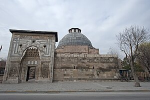
Karatay Madrasa
Madrasa in Konya, Turkey
Distance: Approx. 5938 meters
Latitude and longitude: 37.87472222,32.49277778
Karatay Madrasa (Turkish: Karatay Medresesi) is a madrasa (a school with a frequently but not absolutely religious focus) in Konya, Turkey located at the foot of the citadel hill, across from the ruins of the Seljuk palace and in view of the Alâeddin Mosque. Since 1954, the building has served as a museum displaying a collection of historic tile art, particularly from the Seljuk period. The madrasa and the Karatay Han, a caravanserai completed in the 1240s, are the largest extant monuments in Konya and its immediate regions.

Sille, Konya
Neighbourhood in Selçuklu, Konya, Turkey
Distance: Approx. 5168 meters
Latitude and longitude: 37.92638889,32.41666667
Sille, also known as Sille Subaşı and historically Sylata, is a neighbourhood of the municipality and district of Selçuklu, Konya Province, Turkey. Its population is 1,191 (2022). Sille Subaşı was one of the few villages where the Cappadocian Greek language was spoken until 1922.

Sille Dam
Distance: Approx. 5552 meters
Latitude and longitude: 37.926224,32.400355
Sille Dam (Turkish: Sille Barajı) is a dam in Konya Province in Turkey.
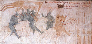
Battle of Iconium (1190)
Battle of the Third Crusade
Distance: Approx. 5298 meters
Latitude and longitude: 37.8667,32.4833
The Battle of Iconium (sometimes referred as the Battle of Konya) took place on May 18, 1190, during the Third Crusade, in the expedition of Frederick Barbarossa to the Holy Land. As a result, Iconium, the capital city of the Sultanate of Rûm under Kilij Arslan II, fell to the Imperial forces.

Konya railway station
Railway station in Konya, Turkey
Distance: Approx. 4731 meters
Latitude and longitude: 37.866333,32.476361
Konya station (Turkish: Konya garı) is an inter-city railway station serving the central anatolian city of Konya. It serves as the southern terminus of the Polatlı–Konya high-speed railway with YHT high-speed trains from Ankara and Istanbul servicing the station. Inter-city trains to Izmir and Adana also terminate at the station.
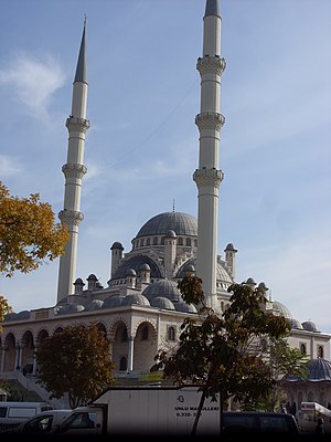
Hacıveyiszade Mosque
Mosque in Konya, Turkey
Distance: Approx. 4921 meters
Latitude and longitude: 37.87,32.48
Hacıveyiszade Mosque (Turkish: Hacıveyiszade Camii) is a mosque situated in the center of the city of Konya in the Anatolia region of Turkey. It was built in memory of Hacıveyiszade Mustafa Kurucu Hoca Efendi, one of the renowned religious scholars of Konya of the recent times. The construction of the mosque was started by the Turkish Religious Foundation (Turkish: Türkiye Diyanet Vakfı) in 1986.

Konya Food and Agriculture University
Agricultural school in Konya, Turkey
Distance: Approx. 4356 meters
Latitude and longitude: 37.8757,32.4748
Konya Food and Agriculture University (KFAU) (Turkish: Konya Gıda ve Tarım Üniversitesi) is a private university in Konya, Turkey. It is Turkey's first specialized university in food and agriculture. KFAU was founded in 2013 by the Scientific Research Technology Education and Culture Foundation (Bilimsel Araştırma Teknoloji Eğitim ve Kültür Vakfı, BARTEK).
Weather in this IP's area
scattered clouds
9 Celsius
6 Celsius
9 Celsius
9 Celsius
1021 hPa
46 %
1021 hPa
890 hPa
10000 meters
5.14 m/s
10 degree
40 %
07:01:37
18:08:51