Country:
Region:
City:
Latitude and Longitude:
Time Zone:
Postal Code:
IP information under different IP Channel
ip-api
Country
Region
City
ASN
Time Zone
ISP
Blacklist
Proxy
Latitude
Longitude
Postal
Route
Luminati
Country
Region
34
City
istanbul
ASN
Time Zone
Europe/Istanbul
ISP
TurkNet Iletisim Hizmetleri A.S.
Latitude
Longitude
Postal
IPinfo
Country
Region
City
ASN
Time Zone
ISP
Blacklist
Proxy
Latitude
Longitude
Postal
Route
db-ip
Country
Region
City
ASN
Time Zone
ISP
Blacklist
Proxy
Latitude
Longitude
Postal
Route
ipdata
Country
Region
City
ASN
Time Zone
ISP
Blacklist
Proxy
Latitude
Longitude
Postal
Route
Popular places and events near this IP address

Monastery of Stoudios
Greek Orthodox monastery in Constantinople
Distance: Approx. 722 meters
Latitude and longitude: 40.99611111,28.92861111
The Monastery of Stoudios, more fully Monastery of Saint John the Forerunner "at Stoudios" (‹See Tfd›Greek: Μονή του Αγίου Ιωάννη του Προδρόμου εν τοις Στουδίου, translit. Monē tou Hagiou Iōannē tou Prodromou en tois Stoudiou), often shortened to Stoudios, Studion or Stoudion (Latin: Studium), was a Greek Orthodox monastery in Constantinople (modern-day Istanbul), the capital of the Byzantine Empire. The residents of the monastery were referred to as Stoudites or Studites.

Samatya
Quarter of Istanbul
Distance: Approx. 245 meters
Latitude and longitude: 41,28.93333333
Samatya (Greek: Ψαμάθεια, romanized: Psamatheia; Armenian: Սամաթիա) is a quarter of the Fatih district of Istanbul. It is located along the Marmara Sea, and borders to the west on the neighborhood of Yedikule (the "Castle of the Seven Towers").

Koca Mustafa Pasha Mosque
Mosque in Istanbul, Turkey
Distance: Approx. 778 meters
Latitude and longitude: 41.0034,28.9286
Koca Mustafa Pasha Mosque (Turkish: Koca Mustafa Paşa Camii; also named Sünbül Efendi Camii) is a former Eastern Orthodox church converted into a mosque by the Ottomans, located in Istanbul, Turkey. The church, as the adjoining monastery, was dedicated to Saint Andrew of Crete, and was named Saint Andrew in Krisei or by-the-Judgment (Greek: Μονὴ τοῦ Ἁγίου Ἀνδρέου ἐν τῇ Κρίσει, Monē tοu Hagiοu Andreοu en tē Krisei). Although heavily transformed during both the Byzantine and the Ottoman eras, it is one of the few extant churches in Istanbul whose foundation goes back to the sixth century.

Sancaktar Hayrettin Mosque
Mosque in Istanbul, Turkey
Distance: Approx. 402 meters
Latitude and longitude: 41.00275,28.93466667
Sancaktar Hayrettin Mosque (Turkish: Sancaktar Hayrettin Câmîi; also Sancaktar Hayrettin Mescidi, where Mescit is the Turkish word for a small mosque, or Sancaktar Mescidi) is part of a former Eastern Orthodox monastery converted into a mosque by the Ottomans. It is generally believed that the small building belonged to the Byzantine Monastery of Gastria (Greek: Μονῆ τῶν Γαστρίων, Monē tōn Gastríōn, meaning "Monastery of the Vases"). The edifice is a minor example of Palaiologan architecture in Constantinople, and is important for historical reasons.
Imperial Library of Constantinople
Ancient library
Distance: Approx. 724 meters
Latitude and longitude: 40.9961,28.9286
The Imperial Library of Constantinople, in the capital city of the Byzantine Empire, was the last of the great libraries of the ancient world. Long after the destruction of the Great Library of Alexandria and the other ancient libraries, it preserved the knowledge of the ancient Greeks and Romans for almost 1,000 years. A series of unintentional fires over the years and wartime damage, including the raids of the Fourth Crusade in 1204, impacted the building and its contents.

Kennedy Avenue
Distance: Approx. 640 meters
Latitude and longitude: 40.9951,28.9309
Kennedy Avenue (Turkish: Kennedy Caddesi) is a 13-kilometre-long (8.08 mi) avenue in Istanbul, Turkey that travels southwest from Sirkeci district to Bakırköy District and most importantly to the Atatürk Airport. The avenue is named for the 35th U.S. President, John F. Kennedy.

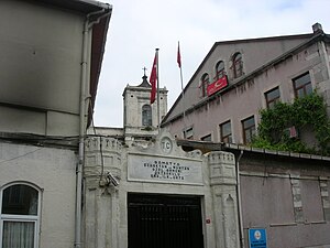
Church of St. George of Samatya
Church in Istanbul, Turkey
Distance: Approx. 387 meters
Latitude and longitude: 41.00188,28.93302
Saint George of Samatya or Surp Kevork (Armenian: Սամաթիոյ Սուրբ Գէորգ Եկեղեցի; Turkish name: Sulu Manastır, meaning: "Water Monastery") is an Armenian church in Istanbul, Turkey. The edifice, built between 1866 and 1887, has been erected above the substructure of a Byzantine church and monastery built in the eleventh century. The complex, dedicated to St.

Church of Saint Menas of Samatya
Church in Istanbul, Turkey
Distance: Approx. 374 meters
Latitude and longitude: 41.000417,28.931897
Saint Menas (Greek: Ἄγιος Μηνάς, pr. Ágios Minás; Turkish: Ayios Minas Kilisesi) is a Greek Orthodox Church in Istanbul. The edifice was built in 1833 near an early Christian Martyrion of the fourth or fifth century, possibly dedicated to the saints Carpus and Papylus (Greek: Μονὴ τῶν ἁγίων Κάρπου καὶ Παπὺλου, Monì ton Agíon Kárpou kai Papýlou ), and on the site of an ancient church dedicated to Hagios Polykarpos.

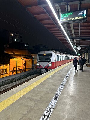
Kocamustafapaşa railway station
Distance: Approx. 260 meters
Latitude and longitude: 40.99972222,28.93305556
Kocamustafapaşa station is a railway station on the Sirkeci-Kazlıçeşme Line. The station is located in the Samatya neighborhood of Istanbul's Fatih district. Kocamustafapaşa was closed in 2013 due to the closure of the whole B1 line, after the opening of the new Marmaray line.

Ese Kapi Mosque
Mosque in Istanbul, Turkey
Distance: Approx. 677 meters
Latitude and longitude: 41.004662,28.939911
Ese Kapi Mosque (Turkish: Ese Kapı Mescidi or Hadim Ibrahim Pasha Mescidi, where mescit is the Turkish word for a small mosque), also "Isa Kapi Mosque", meaning in English "Mosque of the Gate of Jesus", is an Ottoman mosque in Istanbul, Turkey. The building was originally a Byzantine Eastern Orthodox church of unknown dedication.

Hekimoğlu Ali Pasha Mosque
Mosque in Fatih, Istanbul, Turkey
Distance: Approx. 769 meters
Latitude and longitude: 41.00615833,28.93497222
The Hekimoğlu Ali Pasha Mosque (Turkish: Hekimoğlu Ali Paşa Camii) is a mosque in the Fatih district of Istanbul, Turkey. It was commissioned by Hekimoğlu Ali Pasha, who served as grand vizier multiple times from the 1730s to 1750s. The mosque was completed in 1734–1735.

Cerrahpaşa railway station
Railway station in Istanbul, Turkey
Distance: Approx. 528 meters
Latitude and longitude: 41.002804,28.940338
Cerrapaşa railway station (Turkish: Cerrapaşa istasyonu) is a railway station on the Istanbul-Pythion railway in Istanbul, Turkey. Opened together with the T6 shuttle line from Kazlıçeşme to Sirkeci on 26 February 2024, Cerrapaşa is the most recently opened railway station in Istanbul. Built on the originally double-track right-of-way, the station has one side platform with one track.
Weather in this IP's area
broken clouds
11 Celsius
10 Celsius
11 Celsius
12 Celsius
1012 hPa
88 %
1012 hPa
1012 hPa
10000 meters
3.09 m/s
350 degree
75 %
07:55:40
17:43:36