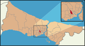
Country:
Region:
City:
Latitude and Longitude:
Time Zone:
Postal Code:
IP information under different IP Channel
ip-api
Country
Region
City
ASN
Time Zone
ISP
Blacklist
Proxy
Latitude
Longitude
Postal
Route
Luminati
Country
Region
34
City
istanbul
ASN
Time Zone
Europe/Istanbul
ISP
TurkNet Iletisim Hizmetleri A.S.
Latitude
Longitude
Postal
IPinfo
Country
Region
City
ASN
Time Zone
ISP
Blacklist
Proxy
Latitude
Longitude
Postal
Route
db-ip
Country
Region
City
ASN
Time Zone
ISP
Blacklist
Proxy
Latitude
Longitude
Postal
Route
ipdata
Country
Region
City
ASN
Time Zone
ISP
Blacklist
Proxy
Latitude
Longitude
Postal
Route
Popular places and events near this IP address

Gaziosmanpaşa
District and municipality in Istanbul, Turkey
Distance: Approx. 1269 meters
Latitude and longitude: 41.04916667,28.90138889
Gaziosmanpaşa (Turkish: [ɡaːziosˈmanpaʃa]; old name: Taşlıtarla) is a developing working class municipality (belediye) and district of Istanbul, Turkey, on its European side. Its area is 12 km2, and its population is 495,998 (2022). Esenler and Bayrampaşa are west, Sultangazi is north and Eyüp is south and east of the district.

Bayrampaşa
District and municipality in Istanbul, Turkey
Distance: Approx. 1369 meters
Latitude and longitude: 41.04805556,28.90027778
Bayrampaşa (pronounced [bajˈɾampaʃa]) is a municipality and district of Istanbul Province, Turkey. Its area is 9 km2, and its population is 275,314 (2022). It is on the European side of the city.

Eyüp Sultan Mosque
Mosque in Eyüp, Istanbul, Turkey
Distance: Approx. 1459 meters
Latitude and longitude: 41.04794722,28.93378611
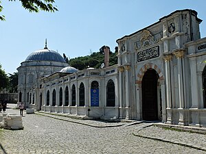
The Eyüp Sultan Mosque (Turkish: Eyüp Sultan Camii) is a mosque in Eyüp district of Istanbul, Turkey. The mosque complex includes a mausoleum marking the spot where Ebu Eyüp el-Ansari (Abu Ayyub al-Ansari), the standard-bearer and companion of the prophet Muhammad, is said to have been buried. On a much older site, the present building dates from the beginning of the 19th century.

Istanbul Nişantaşı University
Private university in İstanbul, Turkey
Distance: Approx. 1154 meters
Latitude and longitude: 41.03944444,28.91222222
Istanbul Nişantaşı University (Turkish: İstanbul Nişantaşı Üniversitesi) is a private, non-profit educational institution, founded in 2012 and located in Istanbul, Turkey. The university is supported financially by the Nişantaşı Education and Culture Foundation. It started education in the academic term 2010-11.

Eyüp Cemetery
Cemetery in Istanbul
Distance: Approx. 1555 meters
Latitude and longitude: 41.05277778,28.93444444
The Eyüp Cemetery (Turkish: Eyüp Mezarlığı), aka Eyüp Sultan Cemetery, is a historic burial ground located in the Eyüp district, on the European side of Istanbul, Turkey. It is administered by the General Directorate of Foundations. One of the oldest and largest Muslim cemeteries in Istanbul, it hosts graves of Ottoman sultans and court members, grand viziers, high-ranking religious authorities, civil servants and military commanders as well as intellectuals, scientists, artists and poets.

Eyüp Gondola
Distance: Approx. 1484 meters
Latitude and longitude: 41.04972222,28.93416667
The Eyüp Gondola, a.k.a. Eyüp–Piyerloti Aerial Cable Car, (Turkish: TF2 Eyüp–Piyerloti teleferik hattı) is a two-station gondola-type line of aerial lift passenger transport system located in Eyüp district of Istanbul, Turkey. Opened on November 30, 2005, the 420 m (1,380 ft) long line serves the Piyerloti Hill from Eyüp at the coast of Golden Horn.

Mahmud Esad Coşan
Turkish academic and writer (1938–2001)
Distance: Approx. 1555 meters
Latitude and longitude: 41.05277778,28.93444444
Mahmud Esad Coşan (14 April 1938 – 4 February 2001) was a Turkish academic author, preacher, professor of Islam and Naqshbandi leader.
Sağmalcılar (Istanbul Metro)
Station of the Istanbul Metro
Distance: Approx. 1228 meters
Latitude and longitude: 41.040908,28.907002
Sağmalcılar is a rapid transit station on the M1 line of the Istanbul Metro. It is located in central Bayrampaşa, adjacent to the O-3 highway. Sağmalcılar was opened on 3 September 1989 as part of the first rapid transit line in Istanbul as well as Turkey and is one of the six original stations of the M1 line.

Rami Barracks
Distance: Approx. 81 meters
Latitude and longitude: 41.04916667,28.91555556
Rami Barracks (Turkish: Rami Kışlası, Ottoman Turkish: Asâkir-i Mansure-i Muhammediye Kışlası) were an Ottoman and later Turkish Army barracks located in the Eyüp district on the European part of Istanbul, Turkey. They were built in the 1770s in the Ottoman Empire era. Currently, it is under restoration for use as a library.
Bayrampaşa Prison
Former prison in Istanbul, Turkey
Distance: Approx. 1340 meters
Latitude and longitude: 41.0441,28.9021
The Bayrampaşa Prison (Turkish: Bayrampaşa Cezaevi) is a former prison in the Bayrampaşa district of Istanbul Province in Turkey. It was established in 1968 in an area of 120.000m².

Mihrişah Sultan Complex
Historic building and charitable complex in Istanbul, Turkey
Distance: Approx. 1526 meters
Latitude and longitude: 41.04847222,28.93463889
The Mihrişah Sultan Complex (Turkish: Mihrişah Valide Sultan Külliyesi) is a külliye (Ottoman charitable foundation) founded by Mihrişah Sultan in the late 18th century. The complex is located next to the Eyüp Sultan Mosque complex in Istanbul, Turkey. The complex's largest component is an imaret (soup kitchen) which is notable for being one of the last imarets in Istanbul to still serve its original purpose.

Rami Library
A library in Istanbul, Eyüpsultan
Distance: Approx. 81 meters
Latitude and longitude: 41.04916667,28.91555556
Rami Library (Turkish: Rami Kütüphanesi) is a public library established in 2023 housed in the redeveloped 18th-century Rami Barracks in Istanbul, Turkey.
Weather in this IP's area
broken clouds
10 Celsius
10 Celsius
10 Celsius
12 Celsius
1013 hPa
88 %
1013 hPa
1000 hPa
10000 meters
3.6 m/s
10 degree
75 %
07:55:52
17:43:33