Country:
 Turkey
Region:
City:
Latitude and Longitude:
Time Zone:
Postal Code:
IP information under different IP Channel
ip-api
Country
Region
City
ASN
Time Zone
ISP
Blacklist
Proxy
Latitude
Longitude
Postal
Route
IPinfo
Country
Region
City
ASN
Time Zone
ISP
Blacklist
Proxy
Latitude
Longitude
Postal
Route
MaxMind
Country
Region
City
ASN
Time Zone
ISP
Blacklist
Proxy
Latitude
Longitude
Postal
Route
Luminati
Country
TRRegion
34
City
istanbul
ASN
Time Zone
Europe/Istanbul
ISP
TurkNet Iletisim Hizmetleri A.S.
Latitude
Longitude
Postal
db-ip
Country
Region
City
ASN
Time Zone
ISP
Blacklist
Proxy
Latitude
Longitude
Postal
Route
ipdata
Country
Region
City
ASN
Time Zone
ISP
Blacklist
Proxy
Latitude
Longitude
Postal
Route
Popular places and events near this IP address

Ecumenical Patriarchate of Constantinople
Autocephalous church of Eastern Orthodox Christianity
Distance: Approx. 714 meters
Latitude and longitude: 41.02916667,28.95166667
The Ecumenical Patriarchate of Constantinople (Greek: Οἰκουμενικὸν Πατριαρχεῖον Κωνσταντινουπόλεως, romanized: Oikoumenikón Patriarkhíon Konstantinoupóleos, IPA: [ikumeniˈkon patriarˈçion konstandinuˈpoleos]; Latin: Patriarchatus Oecumenicus Constantinopolitanus; Turkish: Rum Ortodoks Patrikhanesi, İstanbul Ekümenik Patrikhanesi, "Roman Orthodox Patriarchate, Ecumenical Patriarchate") is one of the fifteen to seventeen autocephalous churches (or "jurisdictions") that together compose the Eastern Orthodox Church. It is headed by the Ecumenical Patriarch of Constantinople. Because of its historical location as the capital of the former Eastern Roman (Byzantine) Empire and its role as the mother church of most modern Orthodox churches, Constantinople holds a special place of honor within Orthodoxy and serves as the seat for the Ecumenical Patriarch, who enjoys the status of primus inter pares (first among equals) among the world's Eastern Orthodox prelates and is regarded as the representative and spiritual leader of Eastern Orthodox Christians.
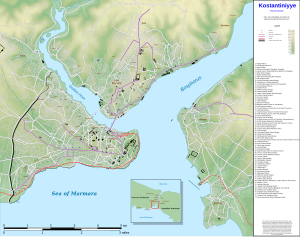
Golden Horn
Primary inlet of the Bosphorus in Istanbul, Turkey
Distance: Approx. 126 meters
Latitude and longitude: 41.02916667,28.96111111
The Golden Horn (Turkish: Altın Boynuz or Haliç; Ancient Greek: Χρυσόκερας, Chrysókeras; Latin: Sinus Ceratinus) is a major urban waterway and the primary inlet of the Bosphorus in Istanbul, Turkey. As a natural estuary that connects with the Bosphorus Strait at the point where the strait meets the Sea of Marmara, the waters of the Golden Horn help define the northern boundary of the peninsula constituting "Old Istanbul" (ancient Byzantium and Constantinople), the tip of which is the promontory of Sarayburnu, or Seraglio Point. This estuarial inlet geographically separates the historic center of Istanbul from the rest of the city, and forms a horn shape, sheltered harbor that in the course of history has protected Greek, Roman, Byzantine, Ottoman and other maritime trade ships for thousands of years.

Fener
Quarter in Marmara, Turkey
Distance: Approx. 696 meters
Latitude and longitude: 41.02888889,28.95194444
Fener (Turkish pronunciation: [feˈnæɾ]; Greek: Φανάρι, Phanári; in English also: Phanar) is a quarter midway up the Golden Horn in the district of Fatih in Istanbul, Turkey. The Turkish name is derived from the Greek word "phanarion" (Medieval Greek: Φανάριον), meaning lantern, streetlight or lamppost; the neighborhood was so called because of a column topped with a lantern which stood here in the Byzantine period and was used as a street light or lighthouse. Fener was a traditionally Greek neighbourhood during the Ottoman era and its streets still contain many old stone houses and churches dating from Byzantine and Ottoman times.

St. George's Cathedral, Istanbul
Church in Istanbul, Turkey
Distance: Approx. 698 meters
Latitude and longitude: 41.02913,28.95187
The Patriarchal Cathedral Church of St. George (Greek: Πατριαρχικός Ναός του Αγίου Γεωργίου; Turkish: Aya Yorgi Kilisesi) is the principal Eastern Orthodox cathedral located in Istanbul, the largest city in Turkey and, as Constantinople, capital of the Byzantine Empire until 1453, and of the Ottoman Empire until 1922. Since about 1600, it has been the seat of the Ecumenical Patriarchate of Constantinople whose leader is regarded as the primus inter pares (first among equals) in the Eastern Orthodox Church, and is frequently looked upon as the spiritual leader of the 300 million Orthodox Christians worldwide.

Kadir Has University
Turkish private university in Istanbul
Distance: Approx. 566 meters
Latitude and longitude: 41.025,28.95888889
Kadir Has University, also known as KHAS, is a foundation university in Fatih, Istanbul, established in 1997 by Kadir Has, the late Turkish industrialist and philanthropist. Kadir Has University has five faculties: Faculty of Art and Design; Faculty of Communication; Faculty of Economics, Administrative and Social Sciences; Faculty of Engineering and Natural Sciences; Faculty of Law. Kadir Has University is a research university, which aims to generate high quality research as well as students with competencies of highest standards by developing a new model of education that is application- and project-based.

Gül Mosque
Former Eastern Orthodox church in Istanbul
Distance: Approx. 479 meters
Latitude and longitude: 41.02666667,28.9565
Gül Mosque (Turkish: Gül Camii, meaning Rose Mosque' in English) is a former Byzantine church in Istanbul, Turkey, converted into a mosque by the Ottomans. It is in Vakıf Mektebi Sokak in the district of Fatih, Istanbul, in the neighbourhood of Ayakapı ('Gate of the Saint'). It lies at the end of the valley which divides the fourth and fifth hills of Constantinople and overlooks the Golden Horn from its imposing position .

Ayakapı
Quarter in Marmara, Turkey
Distance: Approx. 479 meters
Latitude and longitude: 41.02666667,28.9565
Ayakapı (Turkish: "The Gate of the Saint", "The holy gate") (the toponym comes from the Turkish word Aya, derived from pronunciation of the Greek word ἁγἰα, meaning "female Saint" and the Turkish word kapı, meaning "gate") is a quarter of Istanbul, Turkey. It is part of the district of Fatih, inside the walled city, and lies on the shore of the Golden Horn. During the Byzantine era, it was named ta Dexiokratiana or ta Dexiokratous in Greek, after the houses owned here by a certain Dexiokrates.

Atatürk Bridge
Bridge in Istanbul, Turkey
Distance: Approx. 780 meters
Latitude and longitude: 41.02419444,28.96530556
Atatürk Bridge (Turkish: Atatürk Köprüsü) is a road bridge across the Golden Horn in Istanbul, Turkey. It is named after Mustafa Kemal Atatürk, the founder and first President of the Republic of Turkey but is sometimes called the Unkapanı Bridge after the district on its western shore.
Pegae (Thrace)
Ancient town near Byzantion
Distance: Approx. 750 meters
Latitude and longitude: 41.035504,28.965242
Pegae or Pegai (Ancient Greek: Πηγαί), also known as Crenides or Krenides (Κρενίδες), both words meaning springs in Greek, was a town of ancient Thrace, near Byzantium. Nearby was fought the Battle of Pegae in March of 921. The site of Pegae is near the modern Kasımpaşa, in European Turkey.
Choiragria
Town of ancient Thrace
Distance: Approx. 566 meters
Latitude and longitude: 41.031338,28.966599
Choiragria (Greek: Χοιραγρία) was a town of ancient Thrace, inhabited during Roman times. Its site is located south of the Meizon River in European Turkey.
Canopus (Thrace)
Town of ancient Thrace
Distance: Approx. 428 meters
Latitude and longitude: 41.032779,28.963627
Canopus (Greek: Κάνωπος) was a town of ancient Thrace, inhabited during Roman times. Its site is located near Hasköy in European Turkey.
Taşkızak Naval Shipyard
Shipyard of Turkish Navy in Istanbul
Distance: Approx. 437 meters
Latitude and longitude: 41.03388,28.96092
Taşkızak Naval Shipyard (Turkish: Askeri Taşkızak Tersanesi) was a shipyard of the Turkish Navy located at the Golden Horn in Istanbul, Turkey. Established in 1455, a big part of the shipyard was relocated to the Istanbul Naval Shipyard in Tuzla, Istanbul in 2000.
Weather in this IP's area
broken clouds
23 Celsius
23 Celsius
22 Celsius
24 Celsius
1015 hPa
79 %
1015 hPa
1015 hPa
6000 meters
9.26 m/s
340 degree
75 %
06:38:04
19:25:50