Country:
 Turkey
Region:
City:
Latitude and Longitude:
Time Zone:
Postal Code:
IP information under different IP Channel
ip-api
Country
Region
City
ASN
Time Zone
ISP
Blacklist
Proxy
Latitude
Longitude
Postal
Route
IPinfo
Country
Region
City
ASN
Time Zone
ISP
Blacklist
Proxy
Latitude
Longitude
Postal
Route
MaxMind
Country
Region
City
ASN
Time Zone
ISP
Blacklist
Proxy
Latitude
Longitude
Postal
Route
Luminati
Country
TRRegion
41
City
kosekoy
ASN
Time Zone
Europe/Istanbul
ISP
TurkNet Iletisim Hizmetleri A.S.
Latitude
Longitude
Postal
db-ip
Country
Region
City
ASN
Time Zone
ISP
Blacklist
Proxy
Latitude
Longitude
Postal
Route
ipdata
Country
Region
City
ASN
Time Zone
ISP
Blacklist
Proxy
Latitude
Longitude
Postal
Route
Popular places and events near this IP address
Kocaeli University
Turkish public university located in Kocaeli
Distance: Approx. 8387 meters
Latitude and longitude: 40.7661,29.9394
Kocaeli University (Turkish: Kocaeli Üniversitesi) is a state university in İzmit, Turkey. It was founded as the Academy of Engineering and Architecture of Kocaeli in 1976. The electrical and mechanical engineering departments, basic sciences, and department of modern languages were the original departments of the academy.

Balaban, Kartepe
Neighbourhood in Kartepe, Kocaeli, Turkey
Distance: Approx. 7875 meters
Latitude and longitude: 40.69388889,30.08805556
Balaban is a neighbourhood of the municipality and district of Kartepe, Kocaeli Province, Turkey. Its population is 1,326 (2022).
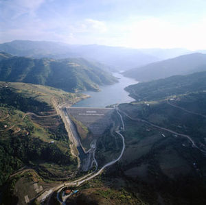
Kirazdere Dam
Dam in Turkey
Distance: Approx. 4001 meters
Latitude and longitude: 40.6741,29.9694
Kirazdere Dam is a dam in Turkey. The development was backed by the Turkish State Hydraulic Works.

Kartepe
District and municipality in Kocaeli, Turkey
Distance: Approx. 4082 meters
Latitude and longitude: 40.73333333,29.96666667
Kartepe is a municipality and district of Kocaeli Province, Turkey. Its area is 301 km2, and its population is 136,625 (2022). The mayor is Mustafa Kocaman (AKP).
Astacus (Bithynia)
Ancient city in Bithynia
Distance: Approx. 5767 meters
Latitude and longitude: 40.714558,29.928794
Astacus (Greek Ἀστακός Βιθυνίας) is an ancient city in Bithynia; it was also called Olbia . Its site is located near the modern Başiskele.
Cengiz Topel Naval Air Station
Airport in Kartepe, Kocaeli Province
Distance: Approx. 8161 meters
Latitude and longitude: 40.73502778,30.08333611
Cengiz Topel Naval Air Station (Turkish: Cengiz Topel Deniz Hava Üssü), a.k.a. Topel Airport or formerly Cengiz Topel Air Base, (IATA: KCO, ICAO: LTBQ) is a Turkish Navy air station located east of İzmit in Kocaeli Province, Turkey. The airport is in joint use for military and civil.

İzmit
District and municipality in Kocaeli, Turkey
Distance: Approx. 8282 meters
Latitude and longitude: 40.76555556,29.94055556
İzmit (Turkish pronunciation: [ˈizmit]) is a municipality and the capital district of Kocaeli Province, Turkey. Its area is 480 km2, and its population is 376,056 (2022). The capital of Kocaeli Province, it is located at the Gulf of İzmit in the Sea of Marmara, about 100 km (62 mi) east of Istanbul, on the northwestern part of Anatolia.
Arslanbey, Kartepe
Neighbourhood in Kartepe, Kocaeli, Turkey
Distance: Approx. 3088 meters
Latitude and longitude: 40.69027778,30.0275
Arslanbey or Aslanbey (Armenian: Ասլանբեկ Aslanbek or Aslanbeg) is a neighbourhood of the municipality and district of Kartepe, Kocaeli Province, Turkey. Its population is 3,927 (2022). Before the Armenian genocide it was populated by Armenians and was known as Aslanbeg.
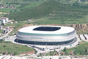
Kocaeli Stadium
Football field owned by Kocaelispor
Distance: Approx. 8085 meters
Latitude and longitude: 40.77472222,30.0175
Kocaeli Stadium is a stadium in İzmit, Turkey. It was opened to public in 2018 with a capacity of 34,829 spectators. It is the new home of Kocaelispor.

Şehit Polis Recep Topaloğlu Sports Hall
Distance: Approx. 7093 meters
Latitude and longitude: 40.76638889,29.97861111
Şehit Polis Recep Topaloğlu Sports Hall (Turkish: Şehit Polis Recep Topaloğlu Spor Salonu) is a multi-purpose indoor arena located in Izmit of Kocaeli Province, Turkey. The venue is used for competitions and trainings of a wide variety of sports branches including basketball, volleyball, handball, fencing, table tennis, wrestling, judo, karate, kick boxing and taekwondo. Opened officially on 6 August 2012, it has a seating capacity of 5,000.
Köseköy railway station
Distance: Approx. 5087 meters
Latitude and longitude: 40.749,30.0062
Köseköy railway station (Turkish: Köseköy istasyonu) is a railway station in Kartepe, Turkey, in the İzmit metropolitan area. TCDD Taşımacılık operates four daily regional trains between Istanbul and Adapazarı that stop at the station. The station was originally built in 1975 by the Turkish State Railways, when the Istanbul-Ankara railway was realigned to bypass İzmit's city center.
Kırkikievler railway station
Distance: Approx. 7721 meters
Latitude and longitude: 40.762,29.9455
Kırkikievler railway station (Turkish: Kırkikievler istasyonu) was a railway station in İzmit, Turkey. It was serviced by the Adapazarı Express regional train service from Istanbul to Adapazarı. Located just south of the city center, the station was originally built in 1975 by the Turkish State Railways, when the Istanbul-Ankara railway was realigned to bypass İzmit's city center.
Weather in this IP's area
broken clouds
17 Celsius
17 Celsius
17 Celsius
20 Celsius
1014 hPa
100 %
1014 hPa
1008 hPa
10000 meters
75 %
06:34:10
19:21:27