Country:
 Turkey
Region:
City:
Latitude and Longitude:
Time Zone:
Postal Code:
IP information under different IP Channel
ip-api
Country
Region
City
ASN
Time Zone
ISP
Blacklist
Proxy
Latitude
Longitude
Postal
Route
IPinfo
Country
Region
City
ASN
Time Zone
ISP
Blacklist
Proxy
Latitude
Longitude
Postal
Route
MaxMind
Country
Region
City
ASN
Time Zone
ISP
Blacklist
Proxy
Latitude
Longitude
Postal
Route
Luminati
Country
TRRegion
35
City
izmir
ASN
Time Zone
Europe/Istanbul
ISP
TurkNet Iletisim Hizmetleri A.S.
Latitude
Longitude
Postal
db-ip
Country
Region
City
ASN
Time Zone
ISP
Blacklist
Proxy
Latitude
Longitude
Postal
Route
ipdata
Country
Region
City
ASN
Time Zone
ISP
Blacklist
Proxy
Latitude
Longitude
Postal
Route
Popular places and events near this IP address
Smyrna
Ancient Greek city, currently İzmir, Turkey
Distance: Approx. 757 meters
Latitude and longitude: 38.41861111,27.13916667
Smyrna ( SMUR-nə; Ancient Greek: Σμύρνη, romanized: Smýrnē, or Σμύρνα, Smýrna) was an Ancient Greek city located at a strategic point on the Aegean coast of Anatolia. Due to its advantageous port conditions, its ease of defence, and its good inland connections, Smyrna rose to prominence. Since about 1930, the city's name has been İzmir.

İzmir
City in Aegean Region of Turkey
Distance: Approx. 882 meters
Latitude and longitude: 38.42,27.14
İzmir is a metropolitan city on the west coast of Anatolia, and capital of İzmir Province. It is the third most populous city in Turkey, after Istanbul and Ankara, and the largest urban agglomeration on the Aegean Sea. In 2019, the city of İzmir had a population of 2,965,900, while İzmir Province had a total population of 4,367,251.
Kemeraltı
Historical market district of İzmir, Turkey
Distance: Approx. 1113 meters
Latitude and longitude: 38.41833333,27.13222222
Kemeraltı (more fully, Kemeraltı Çarşısı) is a historical market (bazaar) district of İzmir, Turkey. It remains one of the liveliest districts of İzmir.

Kadifekale
Castle in İzmir, Turkey
Distance: Approx. 348 meters
Latitude and longitude: 38.41388889,27.14583333
Kadifekale (literally "the velvet castle" in Turkish) is a hilltop castle in İzmir, Turkey. The castle is located on the Mount Pagos (Greek: Πάγος, Pagus under the Roman Empire) which has an elevation of 186 metres. It was built in the 3rd century BC. The castle is located at a distance of about 2 km from the shoreline and commands a general view of a large part of the city of İzmir, as well as of the Gulf of İzmir.
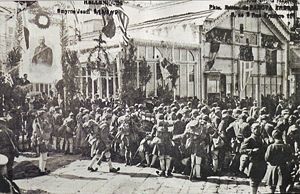
Greek landing at Smyrna
Military engagement
Distance: Approx. 755 meters
Latitude and longitude: 38.4186,27.1392
The Greek landing at Smyrna (Greek: Ελληνική απόβαση στη Σμύρνη; Turkish: İzmir'in İşgali, Occupation of İzmir) was a military operation by Greek forces starting on May 15, 1919 which involved landing troops in the city of Smyrna and surrounding areas. The Allied powers sanctioned and oversaw the planning of the operation and assisted by directing their forces to take over some key locations and moving warships to the Smyrna harbor. During the landing, a shot was fired on the Greek 1/38 Evzone Regiment and significant violence ensued with Greek troops and Greek citizens of Smyrna participating.

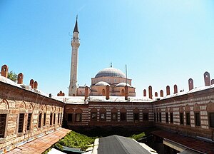
Salepçioğlu Mosque
Distance: Approx. 1015 meters
Latitude and longitude: 38.4171,27.1325
Salepçioğlu Mosque (Salepçioğlu Camii) is a Mosque in İzmir, Turkey located next to Konak Square in the heart of the city. The mosque which was constructed in the year 1905, is named after its patron Salepçizade Hoca Ahmed Efendi.

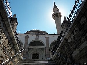
Kestanepazarı Mosque
Distance: Approx. 1080 meters
Latitude and longitude: 38.4199,27.1347
Kestanepazarı Mosque (Kestanepazarı Camii in Turkish, meaning "Chestnut Market Mosque") is a historical Mosque in İzmir, Turkey. An inscription on the Mosque recorded by the traveler Evliya Çelebi, stated that it was constructed by Ahmet Ağa in 1078 according to the Islamic calendar (circa 1668 CE). The Mosque was expanded by Eminzade Ahmet Ağa and reached its present-day appearance in the 19th century.
Başdurak Mosque
Distance: Approx. 1038 meters
Latitude and longitude: 38.41847222,27.13347222
Başdurak Mosque (Başdurak Camii) is a historical Mosque in İzmir, Turkey.

Signora Giveret Synagogue
Synagogue in İzmir, Turkey
Distance: Approx. 1047 meters
Latitude and longitude: 38.42,27.1355
The Signora Giveret Synagogue (Turkish: Sinyora giveret sinagogu) is an Orthodox Jewish synagogue in the city of Izmir, Turkey. The synagogue dates back to the 16th century and is still in use today.

Atatürk Mask
Sculpture in İzmir, Turkey
Distance: Approx. 756 meters
Latitude and longitude: 38.40605556,27.14580556
The Atatürk Mask (Turkish: Atatürk Maskı) is a large concrete bust of Mustafa Kemal Atatürk, founder of modern Turkey, located in Buca district of İzmir. The sculpture was completed in 2009 at a cost of ₺4.2 million.
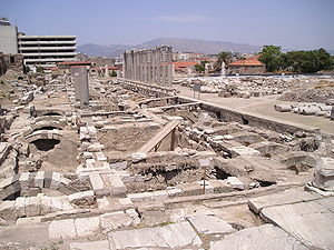
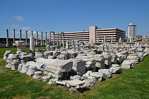
Agora of Smyrna
Square of ancient İzmir
Distance: Approx. 837 meters
Latitude and longitude: 38.41888889,27.13777778
The Agora of Smyrna, alternatively known as the Agora of İzmir (Turkish: İzmir Agorası), is an ancient Roman agora located in Smyrna (present-day İzmir, Turkey). Originally built by the Greeks in the 4th century BC, the agora was ruined by an earthquake in 178 AD. Roman Emperor Marcus Aurelius ordered its reconstruction. Excavations started in 1933.

İzmir Women's Museum
Women museum in İzmir
Distance: Approx. 950 meters
Latitude and longitude: 38.42083333,27.14222222
İzmir Women's Museum is a museum in İzmir, Turkey. It is at 38°25′15″N 27°08′32″E in Konak secondary municipality of İzmir. The museum building is a three floor-historical building in Tilkilik neighborhood.
Weather in this IP's area
clear sky
24 Celsius
24 Celsius
23 Celsius
24 Celsius
1012 hPa
57 %
1012 hPa
995 hPa
10000 meters
8.23 m/s
350 degree
06:47:15
19:31:12