Country:
 Turkey
Region:
City:
Latitude and Longitude:
Time Zone:
Postal Code:
IP information under different IP Channel
ip-api
Country
Region
City
ASN
Time Zone
ISP
Blacklist
Proxy
Latitude
Longitude
Postal
Route
IPinfo
Country
Region
City
ASN
Time Zone
ISP
Blacklist
Proxy
Latitude
Longitude
Postal
Route
MaxMind
Country
Region
City
ASN
Time Zone
ISP
Blacklist
Proxy
Latitude
Longitude
Postal
Route
Luminati
Country
TRRegion
34
City
istanbul
ASN
Time Zone
Europe/Istanbul
ISP
TurkNet Iletisim Hizmetleri A.S.
Latitude
Longitude
Postal
db-ip
Country
Region
City
ASN
Time Zone
ISP
Blacklist
Proxy
Latitude
Longitude
Postal
Route
ipdata
Country
Region
City
ASN
Time Zone
ISP
Blacklist
Proxy
Latitude
Longitude
Postal
Route
Popular places and events near this IP address
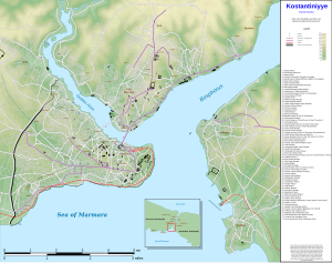
Golden Horn
Primary inlet of the Bosphorus in Istanbul, Turkey
Distance: Approx. 351 meters
Latitude and longitude: 41.02916667,28.96111111
The Golden Horn (Turkish: Altın Boynuz or Haliç; Ancient Greek: Χρυσόκερας, Chrysókeras; Latin: Sinus Ceratinus) is a major urban waterway and the primary inlet of the Bosphorus in Istanbul, Turkey. As a natural estuary that connects with the Bosphorus Strait at the point where the strait meets the Sea of Marmara, the waters of the Golden Horn help define the northern boundary of the peninsula constituting "Old Istanbul" (ancient Byzantium and Constantinople), the tip of which is the promontory of Sarayburnu, or Seraglio Point. This estuarial inlet geographically separates the historic center of Istanbul from the rest of the city, and forms a horn shape, sheltered harbor that in the course of history has protected Greek, Roman, Byzantine, Ottoman and other maritime trade ships for thousands of years.
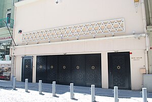
Neve Shalom Synagogue
Synagogue in Istanbul, Turkey
Distance: Approx. 721 meters
Latitude and longitude: 41.02686,28.97254
Neve Shalom Synagogue (Turkish: Neve Şalom Sinagogu, Hebrew: בית הכנסת נווה שלום; lit. "Oasis of Peace" or "Valley of Peace") is a synagogue in the Karaköy quarter of Beyoğlu district, in Istanbul, Turkey. The synagogue was built in response to an increase in the Jewish population in the old Galata neighborhood (today encompassed by Beyoğlu district) in the late 1930s.

Pera Palace Hotel
Museum hotel in Beyoğlu, Istanbul, Turkey
Distance: Approx. 724 meters
Latitude and longitude: 41.03111111,28.97361111
The Pera Palace Hotel (Turkish: Pera Palas Oteli) is a historic special category hotel and museum hotel located in the Beyoğlu (Pera) district in Istanbul, Turkey. It was built in 1892 for the purpose of hosting the passengers of the Orient Express and was named after the place where it is located. It holds the title of "the oldest European hotel in Turkey".

Recep Tayyip Erdoğan Stadium
Distance: Approx. 689 meters
Latitude and longitude: 41.03277778,28.9725
Recep Tayyip Erdoğan Stadium (also known as Kasımpaşa Stadium) is a multi-use stadium in the Kasımpaşa neighbourhood of Istanbul, Turkey. It is currently used mostly for football matches, and is the home stadium of Kasımpaşa S.K. The stadium capacity was extended to 14,234 spectators. Due to extension works, Kasımpaşa played most of its home matches in the Atatürk Olympic Stadium in the 2007–2008 season.

Atatürk Bridge
Bridge in Istanbul, Turkey
Distance: Approx. 658 meters
Latitude and longitude: 41.02419444,28.96530556
Atatürk Bridge (Turkish: Atatürk Köprüsü) is a road bridge across the Golden Horn in Istanbul, Turkey. It is named after Mustafa Kemal Atatürk, the founder and first President of the Republic of Turkey but is sometimes called the Unkapanı Bridge after the district on its western shore.

Şişhane (Istanbul Metro)
Station of the Istanbul Metro
Distance: Approx. 680 meters
Latitude and longitude: 41.0278,28.9726
Şişhane is an underground station on the M2 line of the Istanbul Metro. The station is located under Meşrutiyet Street in Beyoğlu, Istanbul. Şişhane has an entrance to Istanbul's famous İstiklâl Caddesi as well as entrances to Kasımpaşa.

Sokollu Mehmed Pasha Mosque, Azapkapı
16th-century Ottoman mosque
Distance: Approx. 611 meters
Latitude and longitude: 41.025,28.96777778
The Sokollu Mehmed Pasha Mosque (Turkish: Sokollu Mehmet Paşa Camii) is a 16th-century Ottoman mosque located in Istanbul, Turkey. The mosque is situated in Azapkapı neighborhood of Beyoğlu district in Istanbul. It is directly beside the Atatürk Bridge across the Golden Horn, but there was no bridge here at the time the mosque was built.
Pegae (Thrace)
Ancient town near Byzantion
Distance: Approx. 602 meters
Latitude and longitude: 41.035504,28.965242
Pegae or Pegai (Ancient Greek: Πηγαί), also known as Crenides or Krenides (Κρενίδες), both words meaning springs in Greek, was a town of ancient Thrace, near Byzantium. Nearby was fought the Battle of Pegae in March of 921. The site of Pegae is near the modern Kasımpaşa, in European Turkey.
Choiragria
Town of ancient Thrace
Distance: Approx. 187 meters
Latitude and longitude: 41.031338,28.966599
Choiragria (Greek: Χοιραγρία) was a town of ancient Thrace, inhabited during Roman times. Its site is located south of the Meizon River in European Turkey.
Canopus (Thrace)
Town of ancient Thrace
Distance: Approx. 323 meters
Latitude and longitude: 41.032779,28.963627
Canopus (Greek: Κάνωπος) was a town of ancient Thrace, inhabited during Roman times. Its site is located near Hasköy in European Turkey.
Neve Shalom Synagogue massacre
Terrorist attack in Turkey
Distance: Approx. 722 meters
Latitude and longitude: 41.02669,28.97242
The Neve Shalom Synagogue massacre happened on 6 September 1986 when a group of suspected Abu Nidal Organization terrorists killed 22 worshipers inside the Neve Shalom Synagogue in Istanbul, Turkey.
Taşkızak Naval Shipyard
Shipyard of Turkish Navy in Istanbul
Distance: Approx. 548 meters
Latitude and longitude: 41.03388,28.96092
Taşkızak Naval Shipyard (Turkish: Askeri Taşkızak Tersanesi) was a shipyard of the Turkish Navy located at the Golden Horn in Istanbul, Turkey. Established in 1455, a big part of the shipyard was relocated to the Istanbul Naval Shipyard in Tuzla, Istanbul in 2000.
Weather in this IP's area
scattered clouds
22 Celsius
22 Celsius
22 Celsius
22 Celsius
1014 hPa
80 %
1014 hPa
1014 hPa
10000 meters
3.6 m/s
340 degree
40 %
06:38:03
19:25:49