Country:
 Turkey
Region:
City:
Latitude and Longitude:
Time Zone:
Postal Code:
IP information under different IP Channel
ip-api
Country
Region
City
ASN
Time Zone
ISP
Blacklist
Proxy
Latitude
Longitude
Postal
Route
IPinfo
Country
Region
City
ASN
Time Zone
ISP
Blacklist
Proxy
Latitude
Longitude
Postal
Route
MaxMind
Country
Region
City
ASN
Time Zone
ISP
Blacklist
Proxy
Latitude
Longitude
Postal
Route
Luminati
Country
TRRegion
05
City
amasya
ASN
Time Zone
Europe/Istanbul
ISP
TurkNet Iletisim Hizmetleri A.S.
Latitude
Longitude
Postal
db-ip
Country
Region
City
ASN
Time Zone
ISP
Blacklist
Proxy
Latitude
Longitude
Postal
Route
ipdata
Country
Region
City
ASN
Time Zone
ISP
Blacklist
Proxy
Latitude
Longitude
Postal
Route
Popular places and events near this IP address
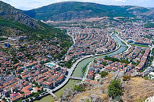
Amasya
City in the Black Sea region of Turkey
Distance: Approx. 5354 meters
Latitude and longitude: 40.65,35.83305556
Amasya (Turkish pronunciation: [aˈmasja]) is a city in northern Turkey, in the Black Sea Region. It was called Amaseia or Amasia in antiquity. It is the seat of Amasya Province and Amasya District.
Aydınlık, Amasya
Village in Amasya, Turkey
Distance: Approx. 5717 meters
Latitude and longitude: 40.7312,35.8368
Aydınlık is a village in the Amasya District, Amasya Province, Turkey. Its population is 731 (2021).
Yeniköy, Amasya
Neighbourhood in Amasya, Amasya, Turkey
Distance: Approx. 1541 meters
Latitude and longitude: 40.67611111,35.88277778
Yeniköy (formerly: Sarılar) is a neighbourhood of the city Amasya, Amasya District, Amasya Province, Turkey. Its population is 422 (2021).
Ermiş, Amasya
Village in Amasya, Turkey
Distance: Approx. 6062 meters
Latitude and longitude: 40.63333333,35.86666667
Ermiş (formerly: Vermiş) is a village in the Amasya District, Amasya Province, Turkey. Its population is 371 (2021).

Ziyaret, Amasya
Municipality in Amasya, Turkey
Distance: Approx. 427 meters
Latitude and longitude: 40.685,35.86888889
Ziyaret is a town (belde) and municipality in the Amasya District, Amasya Province, Turkey. Its population is 4,084 (2021).
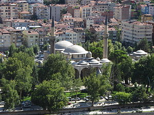
Bayezid II Mosque, Amasya
Mosque in Amasya, Turkey
Distance: Approx. 5687 meters
Latitude and longitude: 40.65,35.827
The Bayezid II Mosque (Turkish: Amasya İkinci Beyazıt Külliyesi) is a historical 15th century Mosque in Amasya, Turkey. The mosque was built in 1486 by order of the Ottoman sultan Bayezid II, it is the largest Külliye of the city.

Burmali Minare Mosque
Mosque in Amasya, Turkey
Distance: Approx. 5380 meters
Latitude and longitude: 40.6501,35.8324
The Burmali Minare Mosque (Turkish: Burmalı Minare Camii; "Burmali Minare" means Spiral Minaret in Turkish) is a historical 13th century Mosque in Amasya, Turkey. The mosque was built between 1237 and 1247 by the Seljuks.

Büyük Aga Medrese
Madrasa in Amasya, Turkey
Distance: Approx. 4528 meters
Latitude and longitude: 40.6586,35.835
Büyük Ağa Medresesi or Kapı Ağa Medresesi is a historical 15th century medrese in Amasya, Turkey.
Amasya Museum
Archaeology museum, Ethnographic museum in Amasya, Turkey
Distance: Approx. 5864 meters
Latitude and longitude: 40.64944444,35.82472222
Amasya Museum, also known as Archaeological Museum of Amasya (Turkish: Amasya Müzesi or Amasya Arkeoloji Müzesi), is a national museum in Amasya, northern Turkey, exhibiting archaeological artifacts found in and around the city as well as ethnographic items related to the region's history of cultural life. Established in 1958, the museum owns nearly twenty-four thousand items for exhibition belonging to eleven historic civilizations.
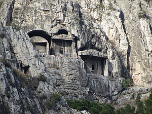
Tombs of the kings of Pontus
Tombs in Turkey
Distance: Approx. 5227 meters
Latitude and longitude: 40.65333333,35.83027778
The Tombs of the kings of Pontus (Turkish: Kral Kaya Mezarları), located in Amasya, northern Turkey, are rock-carved tombs of different sizes, forming the royal necropolis of the Pontic kings. The site was added to the tentative list in the cultural category of UNESCO World Heritage Site on April 13, 2014. The royal necropolis is located on the southern hillside of the 272 m (892 ft)-high Mount Harşena north of the city Amasya and the river Yeşilırmak.
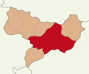
Amasya District
District of Amasya Province, Turkey
Distance: Approx. 5340 meters
Latitude and longitude: 40.65,35.83333333
Amasya District (also: Merkez, meaning "central") is a district of Amasya Province of Turkey. Its seat is the city Amasya. Its area is 1,889 km2, and its population is 147,380 (2021).

Mount Harşena
Mountain peak in Turkey
Distance: Approx. 5176 meters
Latitude and longitude: 40.655,35.82888889
Mount Harşena (Turkish: Harşena Dağı), is a mountain located in Amasya, the capital of the Amasya Province of Turkey. It has a height of 272 m (892 ft). Mount Harşena was added to the tentative list in the cultural category of UNESCO World Heritage Site on 13 April 2015 alongside the tombs of the kings of Pontus.
Weather in this IP's area
scattered clouds
19 Celsius
19 Celsius
19 Celsius
19 Celsius
1017 hPa
84 %
1017 hPa
955 hPa
10000 meters
3.23 m/s
4.07 m/s
45 degree
46 %
06:39:09
18:09:07