Country:
 Turkey
Region:
City:
Latitude and Longitude:
Time Zone:
Postal Code:
IP information under different IP Channel
ip-api
Country
Region
City
ASN
Time Zone
ISP
Blacklist
Proxy
Latitude
Longitude
Postal
Route
IPinfo
Country
Region
City
ASN
Time Zone
ISP
Blacklist
Proxy
Latitude
Longitude
Postal
Route
MaxMind
Country
Region
City
ASN
Time Zone
ISP
Blacklist
Proxy
Latitude
Longitude
Postal
Route
Luminati
Country
TRRegion
34
City
istanbul
ASN
Time Zone
Europe/Istanbul
ISP
TurkNet Iletisim Hizmetleri A.S.
Latitude
Longitude
Postal
db-ip
Country
Region
City
ASN
Time Zone
ISP
Blacklist
Proxy
Latitude
Longitude
Postal
Route
ipdata
Country
Region
City
ASN
Time Zone
ISP
Blacklist
Proxy
Latitude
Longitude
Postal
Route
Popular places and events near this IP address
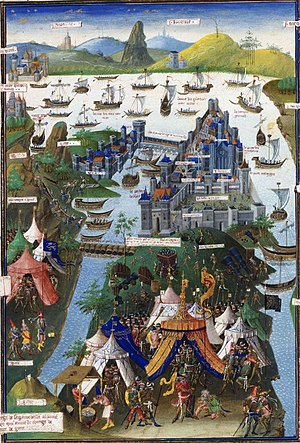
Fall of Constantinople
Ottoman capture of the Byzantine capital
Distance: Approx. 1013 meters
Latitude and longitude: 41.03,28.935
The fall of Constantinople, also known as the conquest of Constantinople, was the capture of the capital of the Byzantine Empire by the Ottoman Empire. The city was captured on 29 May 1453 as part of the culmination of a 53-day siege which had begun on 6 April. The attacking Ottoman Army, which significantly outnumbered Constantinople's defenders, was commanded by the 21-year-old Sultan Mehmed II (later nicknamed "the Conqueror"), while the Byzantine army was led by Emperor Constantine XI Palaiologos.
Karagümrük
Neighborhood in the Fatih district of Istanbul, Turkey
Distance: Approx. 852 meters
Latitude and longitude: 41.02555556,28.93527778
Karagümrük is a neighbourhood in the municipality and district of Fatih, Istanbul Province, Turkey. Its population is 10,649 (2022). The neighborhood gives its name to a professional football club Fatih Karagümrük S.K., also called Karagümrükspor, that is based in the Karagümrük neighbourhood since 1926.
Sulukule
Quarter in Marmara, Turkey
Distance: Approx. 754 meters
Latitude and longitude: 41.02638889,28.93388889
Sulukule (literally: "Water tower") is a historic quarter in the Fatih district of Istanbul, Turkey. It is within the area of Istanbul’s historic peninsula, adjacent to the western part of the city walls. The area has historically been occupied by Romani communities.

Kara Ahmed Pasha Mosque
Mosque in Istanbul, Turkey
Distance: Approx. 520 meters
Latitude and longitude: 41.02111111,28.92916667
The Kara Ahmed Pasha Mosque or Gazi Ahmed Pasha Mosque (Turkish: Kara Ahmet Paşa Camii) is a 16th-century Ottoman mosque near the city walls in Istanbul, Turkey. It was designed by the imperial architect Mimar Sinan and completed in around 1572.
Philopatium
Former palace in Constantinople
Distance: Approx. 734 meters
Latitude and longitude: 41.03,28.92
Philopatium or Philopation (Greek: Φιλοπάτιον) was the name of a palace and region outside the walls of the Byzantine capital Constantinople (modern Istanbul, Turkey), known for its parks and gardens. According to 11th-century accounts, it was located north of Constantinople, just outside the Blachernae walls. Competing accounts place it seaward of the Golden Gate.

Manastır Mosque, Istanbul
Mosque in Istanbul, Turkey
Distance: Approx. 861 meters
Latitude and longitude: 41.01735,28.92838
Manastır Mosque (Turkish: Manastır Mescidi; also Mustafa Çavuş Mescidi, where mescit is the Turkish word for a small mosque) is a former Eastern Orthodox church converted into a mosque by the Ottomans. Neither archeological excavations nor medieval sources have made it possible to find a satisfactory answer as to its original dedication as a church. It is however possible that the small building was part of the Byzantine monastery dedicated to the Holy Martyrs Menodora, Metrodora, and Nymphodora (Greek: Μονῆ τῶν Άγίων Μηνοδώρας, Μητροδώρας καὶ Νυμφοδώρας), or an annex of the nunnery of Kyra Martha (Greek: Μονῆ τἠς Κυράς Μάρθας).

Merkezefendi Cemetery
Cemetery in Istanbul, Turkey
Distance: Approx. 1081 meters
Latitude and longitude: 41.01562,28.92065
The Merkezefendi Cemetery (Turkish: Merkezefendi Mezarlığı) is a burial ground situated in Merkezefendi neighborhood of Zeytinburnu district on the European part of Istanbul, Turkey. The neighborhood and the cemetery are named after Merkez Efendi, an Ottoman Islamic scholar and Sufi (1463–1552). Many renowned intellectuals, writers and artists rest in this old cemetery covering an area of 27,800 m2 (299,000 sq ft).

Topkapı—Ulubatlı (Istanbul Metro)
Station of the Istanbul Metro
Distance: Approx. 474 meters
Latitude and longitude: 41.023592,28.930655
Topkapı—Ulubatlı is an underground station on the M1 line of the Istanbul Metro. It is located in eastern Fatih between the neighborhoods of Karagümrük and Topkapı in Istanbul. An out-of-system transfer to Vatan station on the T4 light-rail line is available as well as connections to İETT city buses.

Bayrampaşa—Maltepe (Istanbul Metro)
Station of the Istanbul Metro
Distance: Approx. 1128 meters
Latitude and longitude: 41.0341,28.9202
Bayrampaşa—Maltepe is a rapid transit station on the M1 line of the Istanbul Metro. It is located in southern Eyüp, adjacent to the O-3 highway. An out-of-system connection Demirkapı station on the T4 light rail line is available as well as İETT buses.

Fatih Mimar Sinan Stadium
Distance: Approx. 758 meters
Latitude and longitude: 41.02388889,28.93416667
Fatih Mimar Sinan Stadium (Turkish: Mimar Sinan Stadı) is a football stadium in the Fatih district of Istanbul, Turkey. It is named after the Ottoman chief architect Mimar Sinan (c. 1488/1490–1588).

Bezmialem Vakıf University
Private university in İstanbul, Turkey
Distance: Approx. 1158 meters
Latitude and longitude: 41.01833333,28.93611111
Bezmialem Vakıf University, originating from the roots of Gureba-i Müslimin, the first modern hospital of the Ottoman Empire that was founded in 1845 by Bezmiâlem Mother Sultana, was transformed into a university in 2010. Bezmialem is one of the first thematic research universities in Health and Life Sciences in Turkey and also a non-profit foundation university which aims to make progress in education, research and health care. It provides education to about 3,500 students and clinical services to 8,000 patients daily with its two main hospitals and three outpatient clinics on both continents of Istanbul.
Topkapı, Fatih
Neighbourhood in Fatih, Istanbul, Turkey
Distance: Approx. 586 meters
Latitude and longitude: 41.02,28.92833333
Topkapı (meaning "Cannon Gate" in Turkish) is a neighbourhood in the municipality and district of Fatih, Istanbul Province, Turkey. Its population is 10,218 (2022).
Weather in this IP's area
clear sky
19 Celsius
19 Celsius
18 Celsius
20 Celsius
1017 hPa
69 %
1017 hPa
1010 hPa
10000 meters
5.14 m/s
40 degree
07:07:10
18:36:40