Country:
 Turkey
Region:
City:
Latitude and Longitude:
Time Zone:
Postal Code:
IP information under different IP Channel
ip-api
Country
Region
City
ASN
Time Zone
ISP
Blacklist
Proxy
Latitude
Longitude
Postal
Route
IPinfo
Country
Region
City
ASN
Time Zone
ISP
Blacklist
Proxy
Latitude
Longitude
Postal
Route
MaxMind
Country
Region
City
ASN
Time Zone
ISP
Blacklist
Proxy
Latitude
Longitude
Postal
Route
Luminati
Country
TRRegion
34
City
istanbul
ASN
Time Zone
Europe/Istanbul
ISP
TurkNet Iletisim Hizmetleri A.S.
Latitude
Longitude
Postal
db-ip
Country
Region
City
ASN
Time Zone
ISP
Blacklist
Proxy
Latitude
Longitude
Postal
Route
ipdata
Country
Region
City
ASN
Time Zone
ISP
Blacklist
Proxy
Latitude
Longitude
Postal
Route
Popular places and events near this IP address

Balıkesir
City in Marmara, Turkey
Distance: Approx. 6316 meters
Latitude and longitude: 39.63333333,27.88333333
Balıkesir (Turkish pronunciation: [baˈlɯkesiɾ]) is a city in the Marmara region of Turkey. It is the seat of Balıkesir Province, which is also a metropolitan municipality. As of 2022, the population of Balıkesir Province is 1,257,590, of which 314,958 in the city proper (the urban part of the districts Altıeylül and Karesi).

Balıkesir Atatürk Stadium
Distance: Approx. 6608 meters
Latitude and longitude: 39.64119444,27.88766667
Balıkesir Atatürk Stadium (Turkish: Balıkesir Atatürk Stadyumu) is a multi-purpose stadium in Balıkesir, Turkey. The stadium holds 15,800 all-seater and was built in 1973 and re-built in 2010. It abides UEFA standards for TFF standards for hosting TFF Second League, TFF First League and also Super Lig games.
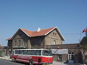
Balıkesir railway station
Railway station in Turkey
Distance: Approx. 6680 meters
Latitude and longitude: 39.647,27.8883
Balıkesir station (Turkish: Balıkesir Garı) is the main railway station in Balıkesir, Turkey. The station was built in 1912 by the Smyrna Cassaba Railway as part of their railway from Manisa to Bandırma. TCDD Taşımacılık operates four daily intercity trains, two of which terminate at Balıkesir.

Karesi, Balıkesir
District and municipality in Balıkesir, Turkey
Distance: Approx. 6316 meters
Latitude and longitude: 39.63333333,27.88333333
Karesi is a municipality and district of Balıkesir Province, Turkey. Its area is 695 km2, and its population is 187,362 (2022). The district was established in 2012, when Balıkesir Province was declared a metropolitan municipality as a part of the 2013 Turkish local government reorganisation (Law no.

Altıeylül
District and municipality in Balıkesir, Turkey
Distance: Approx. 6240 meters
Latitude and longitude: 39.6453,27.8833
Altıeylül is a municipality and district of Balıkesir Province, Turkey. Its area is 956 km2, and its population is 183,736 (2022). The district was established in 2012, when Balıkesir Province was declared a metropolitan municipality as a part of the 2013 Turkish local government reorganisation (Law no.

Balıkesir High School
School in Balıkesir, TR
Distance: Approx. 5681 meters
Latitude and longitude: 39.6461,27.8767
Balıkesir High School (Turkish: Balıkesir Lisesi), in Balıkesir, Turkey, was founded in 1885 with the name of Balıkesir Sultanisi.

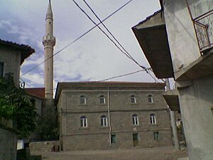
Zagan Pasha Mosque
15th-century Ottoman-era mosque in Balıkesir, northwestern Turkey
Distance: Approx. 5995 meters
Latitude and longitude: 39.6488075,27.8800449
Zagan Pasha Mosque (Turkish: Zağnospaşa Camii) is a historic mosque in Balıkesir, northwest Turkey. It is known as the place, where Mustafa Kemal Atatürk delivered his famous "Balıkesir Khutbah" in 1923. The mosque was built in 1461 by Zagan Pasha (fl.
Gökköy railway station
Railway station near Gökköy, Turkey
Distance: Approx. 5428 meters
Latitude and longitude: 39.5952,27.8265
Gökköy railway station (Turkish: Gökköy istasyonu) is a railway station opened 2015 near Gökköy, Turkey. The station is a part of the Gökköy Logistics Center. TCDD Taşımacılık operates three daily intercity trains from Eskişehir and Bandırma to İzmir.
Çukurhüseyin railway station
Railway station near Çukurhüseyin, Balıkesir in Turkey
Distance: Approx. 8940 meters
Latitude and longitude: 39.5728,27.7586
Çukurhüseyin railway station is a railway station near the village of Çukurhüseyin, Balıkesir in Turkey. TCDD Taşımacılık operates a daily intercity train from Izmir to Bandırma. Since passenger traffic is low, the station acts a siding to allow trains to pass.
Kesirven, Altıeylül
Village in Turkey
Distance: Approx. 8881 meters
Latitude and longitude: 39.576,27.868
Kesirven (formerly: Akçakaya) is a neighbourhood in the municipality and district of Altıeylül of Balıkesir Province in Turkey. Its population is 1,141 (2022).
Dereçiftlik, Altıeylül
Village in Turkey
Distance: Approx. 8857 meters
Latitude and longitude: 39.563,27.804
Dereçiftlik is a neighbourhood in the municipality and district of Altıeylül of Balıkesir Province in Turkey. Its population is 377 (2022).
Gökköy, Altıeylül
Village in Turkey
Distance: Approx. 3869 meters
Latitude and longitude: 39.608,27.817
Gökköy is a neighbourhood in the municipality and district of Altıeylül of Balıkesir Province in Turkey. Its population is 1,428 (2022).
Weather in this IP's area
scattered clouds
16 Celsius
14 Celsius
16 Celsius
16 Celsius
1023 hPa
39 %
1023 hPa
969 hPa
10000 meters
7.72 m/s
40 degree
40 %
07:22:00
18:25:24