Country:
Region:
City:
Latitude and Longitude:
Time Zone:
Postal Code:
IP information under different IP Channel
ip-api
Country
Region
City
ASN
Time Zone
ISP
Blacklist
Proxy
Latitude
Longitude
Postal
Route
Luminati
Country
Region
c
City
gazipur
ASN
Time Zone
Asia/Dhaka
ISP
ORCL-CHICAGO-PP
Latitude
Longitude
Postal
IPinfo
Country
Region
City
ASN
Time Zone
ISP
Blacklist
Proxy
Latitude
Longitude
Postal
Route
db-ip
Country
Region
City
ASN
Time Zone
ISP
Blacklist
Proxy
Latitude
Longitude
Postal
Route
ipdata
Country
Region
City
ASN
Time Zone
ISP
Blacklist
Proxy
Latitude
Longitude
Postal
Route
Popular places and events near this IP address

Hazrat Shahjalal International Airport
International airport in Dhaka, Bangladesh
Distance: Approx. 992 meters
Latitude and longitude: 23.84277778,90.40055556
Hazrat Shahjalal International Airport (Bengali: হযরত শাহ্জালাল আন্তর্জাতিক বিমানবন্দর, Romanized: Hôzrôt Shahjalal Antôrjatik Bimanbôndôr) (IATA: DAC, ICAO: VGHS, formerly VGZR) is the main international airport serving Dhaka City, the capital city of Bangladesh, and it is the largest airport in Bangladesh. It is located in Kurmitola, 17 km (11 mi) from the city centre, in the northern part of Dhaka. The airport is also used as a base for the Bangladesh Air Force, named BAF Base Bangabandhu.
Aga Khan School, Dhaka
Private school in Uttara, Dhaka, Bangladesh
Distance: Approx. 1505 meters
Latitude and longitude: 23.86066944,90.40224444
The Aga Khan School, Dhaka, is an English Medium School, in Uttara, Dhaka under the Aga Khan Development Network (AKDN) and the Aga Khan Education Service, Bangladesh (AKES,B). It is one of the earliest private English Medium schools in Bangladesh founded in 1988, in a small campus in Siddeshwari, Dhaka.

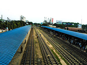
Dhaka Airport railway station
Railway station in Dhaka, Bangladesh
Distance: Approx. 437 meters
Latitude and longitude: 23.85222222,90.40833333
Airport railway station or Biman Bandar railway station is a railway station in Dhaka, the capital of Bangladesh. Situated opposite to Hazrat Shahjalal International Airport, it can be accessed from the Airport Road.
Northern University, Bangladesh
Private university in Bangladesh
Distance: Approx. 1634 meters
Latitude and longitude: 23.8494,90.4242
Northern University Bangladesh (Bengali: নর্দান বিশ্ববিদ্যালয় বাংলাদেশ) or NUB is a private university in Dhaka, Bangladesh. It was established in 2002. The university was sponsored and funded by the International Business Agriculture & Technology (IBAT) Trust.

Medical College for Women and Hospital
Private medical college and hospital in Bangladesh
Distance: Approx. 1359 meters
Latitude and longitude: 23.8584,90.4007
Medical College for Women and Hospital (MCW&H) is a Bangladeshi private medical college for women. It has two academic campuses in Uttara, Dhaka, one in Sector - 1 and the other in Uttarkhan. The college is affiliated with the Dhaka University as a constituent college.
Armed Police Battalion School & College
School in Dhaka, Bangladesh
Distance: Approx. 1151 meters
Latitude and longitude: 23.8584,90.4058
Armed Police Battalion School & College is a Higher secondary school at Uttara in the city of Dhaka in Bangladesh.
2017 Dhaka RAB camp suicide bombing
Distance: Approx. 353 meters
Latitude and longitude: 23.8504,90.4108
The 2017 Dhaka RAB Camp suicide bombing was an attempted suicide attack in the under construction compound of the elite Rapid Action Battalion in Dhaka, Bangladesh on 17 March 2017. The suicide attempt failed to cause any mass casualties, injuries or deaths. Only the lone suicide bomber died.
Jatir Janak Bangabandhu Sheikh Mujibur Rahman Govt. College
Government college in Dhaka, Bangladesh
Distance: Approx. 518 meters
Latitude and longitude: 23.8524,90.4106
Jatir Janak Bangabandhu Sheikh Mujibur Rahman Govt. College, Dhaka (Bengali: জাতির জনক বঙ্গবন্ধু শেখ মুজিবুর রহমান সরকারি মহাবিদ্যালয়,ঢাকা) is a public college situated near Airport Road at Dhaka in Bangladesh. The college was established in 2013 and opened on 7 August 2014 with 580 students.
Bimanbandar Thana (Dhaka)
Thana in Dhaka North City Corporation, Bangladesh
Distance: Approx. 399 meters
Latitude and longitude: 23.8509,90.4109
Bimanbandar Thana is a thana of Dhaka City.
Bangladesh Police Swimming Complex
Distance: Approx. 1015 meters
Latitude and longitude: 23.856978,90.405129
Bangladesh Police Swimming Complex is a swimming sports competition hosting and training swimming pool operated by Bangladesh Police which open in 2019. It is located inside the headquarters of the Armed Police Battalion in Uttara, Dhaka. The sports facility built at a cost of 20 crore Bangladeshi taka.
Hazrat Shahjalal International Airport Pedestrian Underpass
Pedestrian underpass in Dhaka, Bangladesh
Distance: Approx. 249 meters
Latitude and longitude: 23.8505238,90.4084548
Hazrat Shahjalal International Airport Pedestrian Underpass (Bengali: হজরত শাহজালাল আন্তর্জাতিক বিমানবন্দর পথচারী আন্ডারপাস) is a pedestrian underpass under construction located in Dhaka, Bangladesh.

BAF Base Bangabandhu
Air base in Dhaka, Bangladesh
Distance: Approx. 1596 meters
Latitude and longitude: 23.8369473,90.3986193
BAF Base Bangabandhu is a one of nine Bangladeshi Air Force bases located at Kurmitola, Dhaka in Bangladesh. It is situated near to the Hazrat Shahjalal International Airport.
Weather in this IP's area
mist
22 Celsius
22 Celsius
22 Celsius
22 Celsius
1014 hPa
83 %
1014 hPa
1012 hPa
2300 meters
06:15:22
17:12:02