Country:
Region:
City:
Latitude and Longitude:
Time Zone:
Postal Code:
IP information under different IP Channel
ip-api
Country
Region
City
ASN
Time Zone
ISP
Blacklist
Proxy
Latitude
Longitude
Postal
Route
Luminati
Country
ASN
Time Zone
Europe/Rome
ISP
ENEL S.p.A
Latitude
Longitude
Postal
IPinfo
Country
Region
City
ASN
Time Zone
ISP
Blacklist
Proxy
Latitude
Longitude
Postal
Route
db-ip
Country
Region
City
ASN
Time Zone
ISP
Blacklist
Proxy
Latitude
Longitude
Postal
Route
ipdata
Country
Region
City
ASN
Time Zone
ISP
Blacklist
Proxy
Latitude
Longitude
Postal
Route
Popular places and events near this IP address

PalaLottomatica
Multi-purpose sports and entertainment arena in Rome, Italy
Distance: Approx. 1083 meters
Latitude and longitude: 41.82536389,12.46654167
Palazzo dello Sport or PalaEUR, formerly known as PalaLottomatica, is a multi-purpose sports and entertainment arena in Rome, Italy. It is located in the heart of the well known modern EUR complex. The arena hosted the 1960 Olympic basketball tournaments.
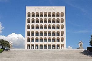
Palazzo della Civiltà Italiana
Building in EUR, Rome
Distance: Approx. 1437 meters
Latitude and longitude: 41.83668333,12.46530833
The Palazzo della Civiltà Italiana, also known as the Palazzo della Civiltà del Lavoro, or in everyday speech as the Colosseo Quadrato ("Square Colosseum"), is a building in the EUR district in Rome.: 199 It was designed in 1938 by three Italian architects: Giovanni Guerrini, Ernesto La Padula, and Mario Romano. The building is an example of Italian Rationalism and fascist architecture with neoclassical design, representing romanità, a philosophy which encompasses the past, present, and future all in one. The enormity of the structure is meant to reflect the fascist regime's new course in Italian history.
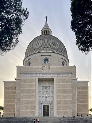
Santi Pietro e Paolo a Via Ostiense
Church in Rome, Italy
Distance: Approx. 869 meters
Latitude and longitude: 41.8337,12.4593
The basilica of Santi Pietro e Paolo a Via Ostiense is one of the titular churches in Rome, to which Cardinal-Priests are appointed. It is a modern building at Piazzale dei Santi Pietro e Paolo 8 in EUR (Esposizione Universale Roma). It is at the west end of the Viale Europa, the last two blocks of which is a monumental approach reserved for pedestrians and paved with polychrome marble.
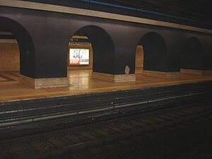
EUR Palasport
Rome metro station
Distance: Approx. 1123 meters
Latitude and longitude: 41.83,12.46666667
EUR Palasport is a station on Line B of the Rome Metro, in the EUR district of Rome between Viale America and Piazza Umberto Elia Terracini. It was opened in 1955 as EUR Marconi but renamed to its present name on the opening of the new Marconi station. Beside it is the artificial lake created for the 1960 Summer Olympics.
Massimiliano Massimo Institute
Secondary school in Rome, Italy
Distance: Approx. 420 meters
Latitude and longitude: 41.82973056,12.45732778
The Massimiliano Massimo Institute (Istituto Massimiliano Massimo) is a Jesuit school in Rome. It is considered one of the most prestigious and exclusive schools in Rome. The school, with over 10,000 former students, has one of the most prestigious alumni registries in Italy.

Olympic Velodrome, Rome
Distance: Approx. 270 meters
Latitude and longitude: 41.82664722,12.45689722
The Olympic Velodrome (Italian: Velodromo Olimpico) was a sports venue located in Rome, Italy. Constructed for the 1960 Summer Olympics, it hosted the track cycling and field hockey events. The velodrome was constructed between 1957 and early 1960.

Piscina delle Rose
Building in Rome
Distance: Approx. 840 meters
Latitude and longitude: 41.83083333,12.4625
The Piscina delle Rose (English: Roses Swimming Pool) is a sports venue located in Rome, Italy. It hosted the preliminaries for the water polo events at the 1960 Summer Olympics.

Torre Eurosky
Skyscraper in Rome
Distance: Approx. 897 meters
Latitude and longitude: 41.81959,12.45763
Torre Eurosky (or Eurosky Tower) is a skyscraper in Rome, Italy. It is the tallest building in Rome and one of the highest residential towers in Italy.

Torre Europarco
Distance: Approx. 1118 meters
Latitude and longitude: 41.81722222,12.45611111
Torre Europarco (English: "Europarco Tower") is a high-rise building in Rome, Italy. It is 120 metres high and has 30 floors. It is the third-tallest building in the city, after the nearby Torre Eurosky and St.

Torre Pontina
Skyscraper in Latina, the tallest building in the city
Distance: Approx. 897 meters
Latitude and longitude: 41.81959,12.45763
Torre Pontina is a skyscraper in Latina, the tallest building in the city and one of the highest residential towers in Italy. The foundation of the building was laid in 2007. The building is near the Latinafiori Shopping Center.
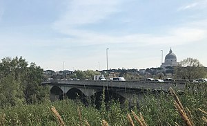
Ponte della Magliana
Bridge in Q.X Ostiense and Q.IX Portuense, Italy
Distance: Approx. 1411 meters
Latitude and longitude: 41.83937778,12.45792778
Ponte della Magliana is a motorway bridge in Rome (Italy). It crosses the Tiber between Pian due Torri (right bank) and Via del Cappellaccio (left bank), linking the Quartieri Portuense and Ostiense, respectively, on the right and on the left of the river. It is currently part of a larger viaduct, which continues on the right bank of the Tiber towards the Colli Portuensi urban zone and the highway to the Fiumicino Airport and on the left one towards the EUR district, the Tre Fontane urban zone and Via Laurentina.
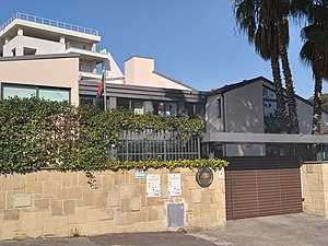
Embassy of Bangladesh, Rome
Embassy
Distance: Approx. 893 meters
Latitude and longitude: 41.82533889,12.46420833
The Embassy of Bangladesh in Rome is the diplomatic mission of The People's Republic of Bangladesh to Italy. It is located at EUR, Rome, Italy. The embassy also operates Consulates-General in Milan, Venice and Naples.
Weather in this IP's area
broken clouds
18 Celsius
17 Celsius
17 Celsius
19 Celsius
1024 hPa
67 %
1024 hPa
1022 hPa
10000 meters
3.09 m/s
100 degree
75 %
06:51:24
16:56:34