Country:
 Switzerland
Region:
City:
Latitude and Longitude:
Time Zone:
Postal Code:
IP information under different IP Channel
ip-api
Country
Region
City
ASN
Time Zone
ISP
Blacklist
Proxy
Latitude
Longitude
Postal
Route
IPinfo
Country
Region
City
ASN
Time Zone
ISP
Blacklist
Proxy
Latitude
Longitude
Postal
Route
MaxMind
Country
Region
City
ASN
Time Zone
ISP
Blacklist
Proxy
Latitude
Longitude
Postal
Route
Luminati
Country
CHRegion
ge
City
geneva
ASN
Time Zone
Europe/Zurich
ISP
World Health Organization (WHO)
Latitude
Longitude
Postal
db-ip
Country
Region
City
ASN
Time Zone
ISP
Blacklist
Proxy
Latitude
Longitude
Postal
Route
ipdata
Country
Region
City
ASN
Time Zone
ISP
Blacklist
Proxy
Latitude
Longitude
Postal
Route
Popular places and events near this IP address

Cimetière des Rois
Cemetery in Geneva, Switzerland
Distance: Approx. 1595 meters
Latitude and longitude: 46.20194444,6.13638889
The Cimetière des Rois (French: Cemetery of Kings) (officially Cimetière de Plainpalais) is a cemetery in Geneva, Switzerland. The cemetery is commonly named after la rue des Rois (French: Kings' Street) near which it is situated. The graveyard was established in 1482 for people who died from plague in the Middle Ages, during the second plague pandemic.
Vernier, Switzerland
Municipality in Geneva, Switzerland
Distance: Approx. 1573 meters
Latitude and longitude: 46.2,6.1
Vernier (French pronunciation: [vɛʁ.nje]) is a municipality in the Canton of Geneva, in Switzerland.

Arve
River in France
Distance: Approx. 779 meters
Latitude and longitude: 46.20129,6.12197
The Arve (French: L'Arve, French pronunciation: [aʁv]) is a river in France (département of Haute-Savoie), and Switzerland (canton of Geneva). A left tributary of the Rhône, it is 108 km (67 mi) long, of which 9 km in Switzerland. Its catchment area is 1,976 km2 (763 sq mi), of which 80 km2 in Switzerland.

Servette
District in Geneva, Switzerland
Distance: Approx. 1172 meters
Latitude and longitude: 46.21212,6.13097
Servette is a district of the city of Geneva, Switzerland. The district's name comes from the Latin word for forest, silva, and means "little forest". Its name alludes to Servette's rural past, before Geneva grew beyond its walls and incorporated the area.

Charmilles Stadium
Distance: Approx. 191 meters
Latitude and longitude: 46.2091,6.1182
Charmilles Stadium was a multi-purpose stadium in Geneva, Switzerland. It was used mostly for football matches, and was the home venue for Servette FC. The stadium was able to hold 9,250 people and was built in 1930 for the Coupe des Nations 1930 tournament. During the 1954 FIFA World Cup the stadium hosted four games.

Institut Florimont
Distance: Approx. 1479 meters
Latitude and longitude: 46.1943,6.1151
The Institut Florimont is a school in Geneva. It was founded in 1905 by the Congrégation des Missionnaires de Saint François de Sales, soon after a law in France prohibited religious congregations of any persuasion. The Institut Florimont started out as a private catholic French-speaking boarding school for boys.

Les Délices
Distance: Approx. 1248 meters
Latitude and longitude: 46.2076,6.1335
Les Délices ("The Delights") was from 1755 to 1760 the home of the French philosopher Voltaire (1694–1778) in Geneva, Switzerland. Since 1952 it has housed the Institut et Musée Voltaire, a museum dedicated to his life and works.

Aïre
Distance: Approx. 1523 meters
Latitude and longitude: 46.19888889,6.10194444
Aïre is a small locality in the Canton of Geneva. It is on the North bank of the river Rhone. It is near Le Lignon, a 1km long block of flats.

Institut et Musée Voltaire
Museum in Geneva, Switzerland
Distance: Approx. 1248 meters
Latitude and longitude: 46.2076,6.1335
The Institut et Musée Voltaire is a museum in Geneva dedicated to the life and works of Voltaire. The museum is housed in Les Délices, which was Voltaire's home from 1755 until 1760. The property was bought by the city of Geneva in 1929, and the museum opened in 1952, founded by Theodore Besterman.
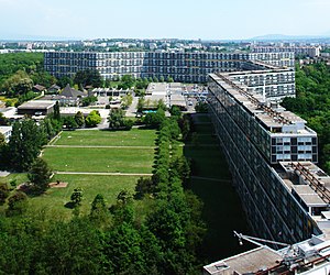
Le Lignon
Urban development in Vernier, Geneva, Switzerland
Distance: Approx. 1580 meters
Latitude and longitude: 46.2031,6.0978
Le Lignon is an urban development in the town of Vernier, canton of Geneva, Switzerland. It was built by architect George Addor between 1964 and 1966 and consists of three large buildings and is one of the largest apartment complexes in the world, containing 2,780 units. It is located on former farmland and was built to address a housing shortage in the 1960s and early 1970s.
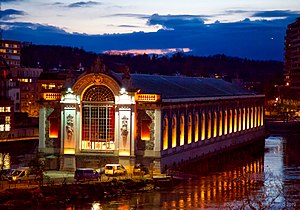
Bâtiment des Forces motrices
Building in Geneva
Distance: Approx. 1634 meters
Latitude and longitude: 46.20472222,6.13812778
The Bâtiment des Forces motrices (BFM), French for "Power plant building", is the power house of a former hydro power plant and waterworks in Geneva called Usine des Forces Motrices, later Usine des Forces Motrices de la Coulouvrenière. The structure is positioned near the point where the River Rhône flows out of Lake Geneva towards Lyon. It was created between 1883 and 1892 (and subjected to subsequent improvements) to exploit the flow of the river to provide water pressure to feed the city's water supply and a hydraulic power network.
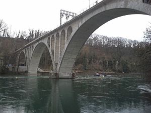
Viaduc de la Jonction
Swiss Viaduct
Distance: Approx. 754 meters
Latitude and longitude: 46.2012,6.1209
The Viaduc de la Jonction (Viaduct of the Junction) is a rail viaduct in Geneva, Switzerland. It was completed in 1945. It is located above the confluence of the rivers Rhône & Arve, locally known as "la Jonction" (the Junction), from which it gets its name.
Weather in this IP's area
broken clouds
15 Celsius
13 Celsius
14 Celsius
15 Celsius
1020 hPa
45 %
1020 hPa
970 hPa
10000 meters
6.69 m/s
30 degree
75 %
07:15:13
19:45:34