Country:
Region:
City:
Latitude and Longitude:
Time Zone:
Postal Code:
IP information under different IP Channel
ip-api
Country
Region
City
ASN
Time Zone
ISP
Blacklist
Proxy
Latitude
Longitude
Postal
Route
Luminati
Country
Region
il
City
clinton
ASN
Time Zone
America/Chicago
ISP
METRO-COMMUNICATIONS-COMPANY
Latitude
Longitude
Postal
IPinfo
Country
Region
City
ASN
Time Zone
ISP
Blacklist
Proxy
Latitude
Longitude
Postal
Route
db-ip
Country
Region
City
ASN
Time Zone
ISP
Blacklist
Proxy
Latitude
Longitude
Postal
Route
ipdata
Country
Region
City
ASN
Time Zone
ISP
Blacklist
Proxy
Latitude
Longitude
Postal
Route
Popular places and events near this IP address

Clinton, Illinois
City in Illinois, United States
Distance: Approx. 862 meters
Latitude and longitude: 40.15222222,-88.95916667
Clinton is the largest city and the county seat in DeWitt County, Illinois, United States. The population was 7,004 at the 2020 census. The city and the county are named for DeWitt Clinton, governor of New York, 1817–1823.

Clinton Lake (Illinois)
Reservoir near Clinton, Illinois, USA
Distance: Approx. 7915 meters
Latitude and longitude: 40.138925,-88.876466
Clinton Lake is a 4,900 acres (19.8 km2) reservoir located near Clinton, Illinois. The lake is a part of the Clinton Lake State Recreation Area, which encompasses 9,300 acres (37.6 km2). It was built in the 1970s as a cooling source for the Clinton Nuclear Generating Station.
C. H. Moore House
Historic house in Illinois, United States
Distance: Approx. 862 meters
Latitude and longitude: 40.15222222,-88.95916667
The C. H. Moore Homestead, in Clinton, Illinois, is one of two Registered Historic Places in DeWitt County. The other, the Magill House, was added to the Register in 2003. CH Moore Homestead DeWitt County Museum was added in 1979.

Magill House
United States historic place
Distance: Approx. 862 meters
Latitude and longitude: 40.15222222,-88.95916667
The Magill House is a historic hotel located at 100 N. Center St. in Clinton, Illinois. Construction on the building began in 1872 and was completed in 1873.

Clintonia Township, DeWitt County, Illinois
Township in Illinois, United States
Distance: Approx. 3310 meters
Latitude and longitude: 40.17888889,-88.97055556
Clintonia Township is one of thirteen townships in DeWitt County, Illinois, USA. As of the 2020 census, its population was 7,315 and it contained 3,543 housing units. Clintonia Township changed its name from Clinton Township June 7, 1859.

Texas Township, DeWitt County, Illinois
Township in Illinois, United States
Distance: Approx. 6071 meters
Latitude and longitude: 40.095,-88.97638889
Texas Township is one of thirteen townships in DeWitt County, Illinois, USA. As of the 2020 census, its population was 1,266 and it contained 523 housing units. The west half of Weldon Springs State Park is in this township.
Weldon Springs State Park
State park in DeWitt County, Illinois
Distance: Approx. 4976 meters
Latitude and longitude: 40.12055556,-88.92361111
Weldon Springs State Park is an Illinois state park; the primary 550-acre (220 ha) area is located near Clinton, Illinois, while a secondary area is located near Monticello, Illinois. The former centers on Salt Creek and the impoundment of a tributary, Weldon Springs, to form Weldon Spring Lake, a reservoir. It is supervised by the Illinois Department of Natural Resources.
Clinton High School (Clinton, Illinois)
School
Distance: Approx. 874 meters
Latitude and longitude: 40.14583333,-88.97777778
Clinton Community High School is a secondary school located in Clinton, Illinois, USA. Students who attend the school live in Clinton and surrounding towns such as Wapella, Kenney, Hallsville and Lane. The superintendent is Curt Nettles and the principal is Jerry Wayne. In 2012–2013, 566 students attended Clinton High School.
Jenkins, Illinois
Unincorporated community in Illinois, United States
Distance: Approx. 5554 meters
Latitude and longitude: 40.15277778,-89.03361111
Jenkins is an unincorporated community in DeWitt County, Illinois, United States. Jenkins is located on Illinois Route 10, 4 miles (6.4 km) west of Clinton.
Ospur, Illinois
Unincorporated community in Illinois, United States
Distance: Approx. 6838 meters
Latitude and longitude: 40.08861111,-88.95527778
Ospur is an unincorporated community in DeWitt County, Illinois, United States. Ospur is 4.5 miles (7.2 km) south of Clinton.
Tunbridge, Illinois
Unincorporated community in Illinois, United States
Distance: Approx. 7886 meters
Latitude and longitude: 40.11361111,-89.04861111
Tunbridge is an unincorporated community in DeWitt County, Illinois, United States. Tunbridge is 2 miles (3.2 km) northeast of Kenney.

DeWitt County Courthouse (Illinois)
Local government building in the United States
Distance: Approx. 747 meters
Latitude and longitude: 40.15388889,-88.96222222
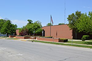
The DeWitt County Courthouse is a government building in Clinton, the county seat of DeWitt County, Illinois, United States. Completed in 1986, it is the fourth courthouse in the history of DeWitt County. Clinton's first settler, James Miller, built a store in October 1835 at the site, and the first house and hotel were those of William Anderson in the following spring.
Weather in this IP's area
overcast clouds
16 Celsius
16 Celsius
16 Celsius
17 Celsius
1005 hPa
95 %
1005 hPa
980 hPa
10000 meters
0.45 m/s
2.24 m/s
111 degree
100 %
06:45:34
16:37:04