Country:
 Netherlands
Region:
City:
Latitude and Longitude:
Time Zone:
Postal Code:
IP information under different IP Channel
ip-api
Country
Region
City
ASN
Time Zone
ISP
Blacklist
Proxy
Latitude
Longitude
Postal
Route
IPinfo
Country
Region
City
ASN
Time Zone
ISP
Blacklist
Proxy
Latitude
Longitude
Postal
Route
MaxMind
Country
Region
City
ASN
Time Zone
ISP
Blacklist
Proxy
Latitude
Longitude
Postal
Route
Luminati
Country
NLRegion
zh
City
rotterdam
ASN
Time Zone
Europe/Amsterdam
ISP
IP Visie Networking B.V.
Latitude
Longitude
Postal
db-ip
Country
Region
City
ASN
Time Zone
ISP
Blacklist
Proxy
Latitude
Longitude
Postal
Route
ipdata
Country
Region
City
ASN
Time Zone
ISP
Blacklist
Proxy
Latitude
Longitude
Postal
Route
Popular places and events near this IP address

Breda
City and municipality in North Brabant, Netherlands
Distance: Approx. 4638 meters
Latitude and longitude: 51.58888889,4.77583333
Breda ( BRAY-də, also UK: BREE-də, US: bray-DAH, Dutch: [breːˈdaː] ) is a city and municipality in the southern part of the Netherlands, located in the province of North Brabant. The name derived from brede Aa ('wide Aa' or 'broad Aa') and refers to the confluence of the rivers Mark and Aa. Breda has 185,072 inhabitants on 13 September 2022 and is part of the Brabantse Stedenrij; it is the ninth largest city/municipality in the country, and the third largest in North Brabant after Eindhoven and Tilburg.

Rat Verlegh Stadion
Multi-purpose stadium in Breda, Netherlands
Distance: Approx. 3066 meters
Latitude and longitude: 51.595,4.75027778
The Rat Verlegh Stadion (Dutch pronunciation: [ˌrɑt fərˈlɛx ˌstaːdijɔn]) is a multi-purpose stadium in Breda, Netherlands. The stadium is the home of the association football club NAC Breda (1996 to present). It was formerly known as FUJIFILM Stadium (1996–2003) and Mycom Stadium (2003–2006), named after two former NAC sponsors.

Prinsenbeek
Town in North Brabant, Netherlands
Distance: Approx. 1771 meters
Latitude and longitude: 51.6,4.71666667
Prinsenbeek is a village and a former municipality in the Dutch province North Brabant. The village is situated west of the motorway A16 (Rotterdam–Antwerp) and the TGV line Amsterdam–Paris. Prinsenbeek is a part of the municipality Breda, and it has 11,419 inhabitants (2005).

Princenhage
Village in Breda in North Brabant, Netherlands
Distance: Approx. 2624 meters
Latitude and longitude: 51.56666667,4.73333333
Princenhage (pronunciation: ['prɪn.sə.na.ɣə]?) is a neighbourhood in the southwest of the city Breda in the Dutch province of North Brabant. The neighbourhood originated as a village so the neighbourhood council or village council, managed to get the neighbourhood, within the municipality council, appointed as a village. Therefor men speaks of "Princenhage Village in Breda".

NAC Stadion
Multi-use stadium in Breda, Netherlands
Distance: Approx. 4029 meters
Latitude and longitude: 51.5825,4.76722222
NAC Stadion was a multi-use stadium in Breda, Netherlands. It was used mostly for football matches and hosted the home matches of NAC Breda. The stadium was able to hold 20,000 people and opened in 1940.
Lies, North Brabant
Hamlet in North Brabant, The Netherlands
Distance: Approx. 1653 meters
Latitude and longitude: 51.57,4.71111111
Lies is a hamlet in the Dutch province of North Brabant. It is located in the municipality of Breda, about 5 km southwest of the city centre.
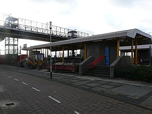
Breda-Prinsenbeek railway station
Railway station in the Netherlands
Distance: Approx. 2440 meters
Latitude and longitude: 51.60527778,4.72166667
Breda-Prinsenbeek is a railway station in the city of Breda. It is located on the Breda–Rotterdam railway, parallel to the A16 motorway. The station serves the village of Prinsenbeek and the Breda city district Haagse Beemden.
NAC stadion Heuvelstraat
Distance: Approx. 2708 meters
Latitude and longitude: 51.57638889,4.74583333
NAC Stadion Heuvelstraat is a football stadium in Breda, Netherlands. It is used for football matches, hosted the home matches of NAC Breda and is now homeground of RKSV Groen Wit. The stadium was able to hold 5,500 people and opened in 1931.
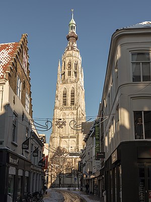
Grote Kerk (Breda)
Distance: Approx. 4582 meters
Latitude and longitude: 51.589,4.775
The Grote Kerk or Onze-Lieve-Vrouwekerk (Church of Our Lady) is the most important monument and a landmark of Breda. The church is built in the Brabantine Gothic style. The tower of the church is 97 meters tall.
Mirabelle (Breda restaurant)
Restaurant in Breda, Netherlands
Distance: Approx. 3201 meters
Latitude and longitude: 51.56628611,4.74451111
Mirabelle is a defunct restaurant located in the Mirabella Estate in Breda, in the Netherlands. It was a fine dining restaurant that was awarded one Michelin star in 1959 and retained that rating until 1967. In recent years the restaurant came into hot water.
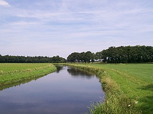
Aa of Weerijs
River in Belgium
Distance: Approx. 4395 meters
Latitude and longitude: 51.5926,4.7714
The Aa of Weerijs (Dutch pronunciation: [ˌaː ʔɔf ˈʋeːrɛis], lit. 'Aa or Weerijs') is a river in Belgium and Netherlands, where it arises from the confluence of the Great Aa (in Wuustwezel) and the Small Aa (in Brecht). In Breda (which means the broad Aa) it is the river in the canals of this city.

Maczek Memorial Breda
Museum in The Netherlands
Distance: Approx. 2673 meters
Latitude and longitude: 51.58186,4.74745
The Maczek Memorial Breda is a museum in Breda, Noord-Brabant, The Netherlands. It tells the story of the liberation of Breda in 1944 by the First Polish Armoured Division led by General Stanisław Maczek. The museum was opened in 2020.
Weather in this IP's area
overcast clouds
15 Celsius
14 Celsius
14 Celsius
16 Celsius
1017 hPa
88 %
1017 hPa
1015 hPa
10000 meters
5.66 m/s
180 degree
100 %
08:12:25
18:39:24