Country:
Region:
City:
Latitude and Longitude:
Time Zone:
Postal Code:
IP information under different IP Channel
ip-api
Country
Region
City
ASN
Time Zone
ISP
Blacklist
Proxy
Latitude
Longitude
Postal
Route
IPinfo
Country
Region
City
ASN
Time Zone
ISP
Blacklist
Proxy
Latitude
Longitude
Postal
Route
MaxMind
Country
Region
City
ASN
Time Zone
ISP
Blacklist
Proxy
Latitude
Longitude
Postal
Route
Luminati
Country
Region
nh
City
amsterdam
ASN
Time Zone
Europe/Amsterdam
ISP
IP Visie Networking B.V.
Latitude
Longitude
Postal
db-ip
Country
Region
City
ASN
Time Zone
ISP
Blacklist
Proxy
Latitude
Longitude
Postal
Route
ipdata
Country
Region
City
ASN
Time Zone
ISP
Blacklist
Proxy
Latitude
Longitude
Postal
Route
Popular places and events near this IP address

Dijkgraafplein
Distance: Approx. 1600 meters
Latitude and longitude: 52.3556,4.786
The Dijkgraafplein is a square in Amsterdam-Osdorp in the Netherlands, lying at the end of Tussen Meer. The square is named after the office of dijkgraaf (the chairman of a water board) in 1962. The Dijkgraafplein lies in the neighborhood that is now known as 'De Punt' and where many streets are named after waterways.
Amsterdam Lelylaan station
Railway station in Amsterdam, Netherlands
Distance: Approx. 1760 meters
Latitude and longitude: 52.35722222,4.83388889
Amsterdam Lelylaan is a railway, metro, tram and bus station in west Amsterdam. It is served by trains of the Nederlandse Spoorwegen and metros of the GVB. The station opened on 1 June 1986. It is located on the Amsterdam-Schiphol railway, a few km south of Amsterdam Sloterdijk railway station.

Amsterdam Nieuw-West
Borough of Amsterdam in North Holland, Netherlands
Distance: Approx. 869 meters
Latitude and longitude: 52.36083333,4.82111111
Amsterdam Nieuw-West (Dutch pronunciation: [ˌɑmstərdɑmniuˈʋɛst]) is a borough (Dutch: stadsdeel) comprising the westernmost neighbourhoods of the city of Amsterdam, Netherlands. It was created in 2010 after a merger of the former boroughs Osdorp, Geuzenveld-Slotermeer and Slotervaart. In 2017, the borough had almost 150,000 inhabitants.
Nieuw Sloten
Neighborhood of Amsterdam in North Holland, Netherlands
Distance: Approx. 1541 meters
Latitude and longitude: 52.34638889,4.8125
Nieuw Sloten is a neighborhood of Amsterdam, Netherlands. Nieuw Sloten was created in the 1990s because the Netherlands failed to become the host of the 1992 Summer Olympics, losing to Barcelona, an agreement was made with local farmers and construction would then begin, Nieuw Sloten would almost overwhelm the older counterpart Sloten, but thanks to local disagreement and defence of the village by the locals, the village was kept untouched along with a small part of the former polders in which the buildings of Nieuw-West currently stand on today.

Oostoever
Neighborhood of Amsterdam in North Holland, Netherlands
Distance: Approx. 1649 meters
Latitude and longitude: 52.36629167,4.83036667
Oostoever is a neighborhood of Amsterdam, Netherlands.
Westelijke Tuinsteden
Neighborhood of Amsterdam in North Holland, Netherlands
Distance: Approx. 1562 meters
Latitude and longitude: 52.37161667,4.82128056
Westelijke Tuinsteden is a neighborhood of Amsterdam, Netherlands. It consists of six neighbourhoods with their own spatial and functional structure: Bos en Lommer, Slotermeer, Geuzenveld, Slotervaart, Overtoomseveld and Osdorp. Since 2010 these districts, with the exception of Bos en Lommer, form part of the Nieuw-West borough.
Amsterdam Gençler Birliği
Dutch football club
Distance: Approx. 1478 meters
Latitude and longitude: 52.37194444,4.79888889
AGB is a Dutch amateur football club based in Amsterdam Nieuw-West, founded on 27 May 1982, the team play their home matches at the Sportpark Ookmeer.
RKSV DCG
Dutch football club
Distance: Approx. 1215 meters
Latitude and longitude: 52.36972222,4.80027778
Rooms Katholieke Sport Vereniging Door Combinatie Groot (RKSV DCG) is a Dutch association football club from Amsterdam.

Postjesweg metro station
Metro station in Amsterdam, Netherlands
Distance: Approx. 1805 meters
Latitude and longitude: 52.3644,4.83396
Postjesweg is a metro station in Amsterdam Nieuw-West and is served by GVB metro line 50 and 51. There is also a bus stop of line 18 at the north side of the main entrance.

Slotervaartziekenhuis
Hospital in Slotervaart neighbourhood of Amsterdam, the Netherlands
Distance: Approx. 1768 meters
Latitude and longitude: 52.3482,4.8258
Slotervaartziekenhuis was a hospital in the Slotervaart neighbourhood of Amsterdam, the Netherlands. It went into administration in October 2018, and was closed within days.

De Bunker (courtroom)
Courtroom in Amsterdam Nieuw-West, Netherlands
Distance: Approx. 1515 meters
Latitude and longitude: 52.359861,4.786111
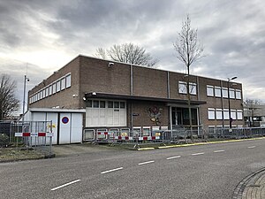
De Bunker is a high security courtroom in Amsterdam Nieuw-West.

Sloterpark
Public park in Amsterdam, the Netherlands
Distance: Approx. 1076 meters
Latitude and longitude: 52.36471944,4.82221944
Sloterpark is an urban park in Amsterdam, the Netherlands. Located in the borough Amsterdam Nieuw-West, around the artificial lake Sloterplas.
Weather in this IP's area
few clouds
20 Celsius
20 Celsius
19 Celsius
21 Celsius
1006 hPa
66 %
1006 hPa
1005 hPa
10000 meters
4.12 m/s
170 degree
20 %
07:04:09
20:12:55
