Country:
 Netherlands
Region:
City:
Latitude and Longitude:
Time Zone:
Postal Code:
IP information under different IP Channel
ip-api
Country
Region
City
ASN
Time Zone
ISP
Blacklist
Proxy
Latitude
Longitude
Postal
Route
IPinfo
Country
Region
City
ASN
Time Zone
ISP
Blacklist
Proxy
Latitude
Longitude
Postal
Route
MaxMind
Country
Region
City
ASN
Time Zone
ISP
Blacklist
Proxy
Latitude
Longitude
Postal
Route
Luminati
Country
NLRegion
nb
City
shertogenbosch
ASN
Time Zone
Europe/Amsterdam
ISP
IP Visie Networking B.V.
Latitude
Longitude
Postal
db-ip
Country
Region
City
ASN
Time Zone
ISP
Blacklist
Proxy
Latitude
Longitude
Postal
Route
ipdata
Country
Region
City
ASN
Time Zone
ISP
Blacklist
Proxy
Latitude
Longitude
Postal
Route
Popular places and events near this IP address

Oss
Municipality in North Brabant, Netherlands
Distance: Approx. 2103 meters
Latitude and longitude: 51.76666667,5.51666667
Oss (Dutch: [ɔs] ) is a municipality and a city in the southern Netherlands, in the province of North Brabant, situated between Nijmegen and 's-Hertogenbosch.

Bernheze
Municipality in North Brabant, Netherlands
Distance: Approx. 2049 meters
Latitude and longitude: 51.73333333,5.53333333
Bernheze (Dutch pronunciation: [ˈbɛr(ə)nˌɦeːzə] ) is a municipality in the southern Netherlands, in the province of North Brabant. It was formed as a rename of Heesch in 1995. The municipalities of Heeswijk-Dinther and Nistelrode had merged into Heesch in 1994.

Maasdonk
Former municipality in North Brabant, Netherlands
Distance: Approx. 5154 meters
Latitude and longitude: 51.73333333,5.46666667
Maasdonk (Dutch pronunciation: [ˈmaːzdɔŋk] ) is a former municipality in the southern Netherlands that existed from 1993 until January 1, 2015, when it was merged into the existing municipalities of 's-Hertogenbosch and Oss.

Berghem
Town in North Brabant, Netherlands
Distance: Approx. 3395 meters
Latitude and longitude: 51.77,5.57472222
Berghem (older spelling: Berchem) is a town in the Dutch municipality of Oss. It is located about 4 km northeast of Oss itself.
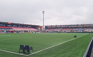
Frans Heesen Stadion
Distance: Approx. 621 meters
Latitude and longitude: 51.755113,5.528175
Frans Heesen Stadion is a multi-use stadium in the city of Oss, Netherlands. It is currently used mostly for association football matches and is the home stadium of TOP Oss. The stadium is able to hold 4,561 spectators.

Heesch, Netherlands
Place in North Brabant, Netherlands
Distance: Approx. 2049 meters
Latitude and longitude: 51.73333333,5.53333333
Heesch (Dutch pronunciation: [ɦeːs]) is a village in the Dutch province of North Brabant. Heesch is next to the village Vinkel. It is located in the municipality of Bernheze, about 3 km south of Oss.

Geffen, Netherlands
Village in North Brabant, Netherlands
Distance: Approx. 5116 meters
Latitude and longitude: 51.73916667,5.46388889
Geffen had been an independent municipality in the Dutch province of North Brabant until 1993, when it became a part of the newly formed municipality Maasdonk. This lasted until 2015, when Maasdonk was dissolved and Geffen became part of Oss. Archeological findings show that the area had been inhabited since the Stone Age (2000 B.C.).
Nistelrode
Village in North Brabant, Netherlands
Distance: Approx. 5844 meters
Latitude and longitude: 51.7,5.55
Nistelrode is a village in the Dutch province of North Brabant. It is located in the municipality of Bernheze, about 8 km south of Oss.

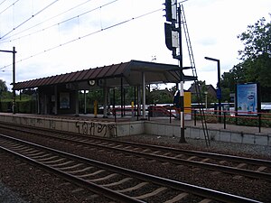
Oss railway station
Railway station in the Netherlands
Distance: Approx. 1532 meters
Latitude and longitude: 51.76527778,5.53166667
Oss is a railway station located in Oss, Netherlands. The station was opened on 4 June 1881 and is located on the Tilburg–Nijmegen railway. The train services are operated by Nederlandse Spoorwegen.
Oss West railway station
Railway station in the Netherlands
Distance: Approx. 2132 meters
Latitude and longitude: 51.75805556,5.50611111
Oss West is a railway station located in Oss, Netherlands.
Cordial (restaurant)
Restaurant in Oss, Netherlands
Distance: Approx. 1870 meters
Latitude and longitude: 51.76798333,5.52860278
Cordial is a restaurant in Oss, Netherlands. It is a fine dining restaurant that was awarded one Michelin star for the period 2002–2018. GaultMillau awarded the restaurant 17 out of 20 points.

Oss rail accident
2018 train collision incident in the Netherlands
Distance: Approx. 2059 meters
Latitude and longitude: 51.75859,5.50757
The Oss railway accident happened on 20 September 2018 when a passenger train collided with a Stint cart on a level crossing at Oss, North Brabant, Netherlands. Four children on the cart were killed, and two were seriously injured. Stint carts were subsequently banned from use on public roads in the Netherlands.
Weather in this IP's area
overcast clouds
14 Celsius
14 Celsius
13 Celsius
15 Celsius
1017 hPa
87 %
1017 hPa
1015 hPa
10000 meters
3.09 m/s
170 degree
100 %
08:09:24
18:35:48