Country:
 Netherlands
Region:
City:
Latitude and Longitude:
Time Zone:
Postal Code:
IP information under different IP Channel
ip-api
Country
Region
City
ASN
Time Zone
ISP
Blacklist
Proxy
Latitude
Longitude
Postal
Route
IPinfo
Country
Region
City
ASN
Time Zone
ISP
Blacklist
Proxy
Latitude
Longitude
Postal
Route
MaxMind
Country
Region
City
ASN
Time Zone
ISP
Blacklist
Proxy
Latitude
Longitude
Postal
Route
Luminati
Country
NLRegion
nb
City
shertogenbosch
ASN
Time Zone
Europe/Amsterdam
ISP
IP Visie Networking B.V.
Latitude
Longitude
Postal
db-ip
Country
Region
City
ASN
Time Zone
ISP
Blacklist
Proxy
Latitude
Longitude
Postal
Route
ipdata
Country
Region
City
ASN
Time Zone
ISP
Blacklist
Proxy
Latitude
Longitude
Postal
Route
Popular places and events near this IP address

Breda
City and municipality in North Brabant, Netherlands
Distance: Approx. 261 meters
Latitude and longitude: 51.58888889,4.77583333
Breda ( BRAY-də, also UK: BREE-də, US: bray-DAH, Dutch: [breːˈdaː] ) is a city and municipality in the southern part of the Netherlands, located in the province of North Brabant. The name derived from brede Aa ('wide Aa' or 'broad Aa') and refers to the confluence of the rivers Mark and Aa. Breda has 185,072 inhabitants on 13 September 2022 and is part of the Brabantse Stedenrij; it is the ninth largest city/municipality in the country, and the third largest in North Brabant after Eindhoven and Tilburg.

Koninklijke Militaire Academie
Military academy in the Netherlands
Distance: Approx. 189 meters
Latitude and longitude: 51.5915,4.7753
The Royal Military Academy (Dutch: Koninklijke Militaire Academie or KMA) is the service academy for the Dutch Army, the Dutch Air Force and the Royal Marechaussee. Located in Breda, Southern Netherlands, the KMA has trained future officers since 1828.
Siege of Breda (1624)
Siege within the Eighty Years' War
Distance: Approx. 1067 meters
Latitude and longitude: 51.58333056,4.78333056
The Siege of Breda of 1624–1625 occurred during the Eighty Years' War. The siege resulted in Breda, a Dutch fortified city, falling into the control of the Army of Flanders.

NAC Stadion
Multi-use stadium in Breda, Netherlands
Distance: Approx. 979 meters
Latitude and longitude: 51.5825,4.76722222
NAC Stadion was a multi-use stadium in Breda, Netherlands. It was used mostly for football matches and hosted the home matches of NAC Breda. The stadium was able to hold 20,000 people and opened in 1940.
Roman Catholic Diocese of Breda
Roman Catholic diocese in the Netherlands
Distance: Approx. 447 meters
Latitude and longitude: 51.5875,4.7774
The Diocese of Breda (Latin: Dioecesis Bredana) is a Latin Church diocese of the Catholic Church in Breda, the Netherlands.

Breda railway station
Railway station in Netherlands
Distance: Approx. 692 meters
Latitude and longitude: 51.595,4.78
Breda railway station is a railway station in Breda in North Brabant, Netherlands. It is situated on the Breda–Rotterdam railway, the Roosendaal–Breda railway and the Breda–Eindhoven railway.

Stedelijk Museum Breda
Museum for visual culture, National museum in Breda, Netherlands
Distance: Approx. 562 meters
Latitude and longitude: 51.5896,4.7811
The Stedelijk Museum Breda, formerly the Museum of the Image (MOTI), is a national museum for visual culture in Breda in the Netherlands. The museum focuses on film, design, photography, fashion, visual arts, architecture, science, and gaming. MOTI closed from 1 January 2017 with the intention of reopening the building in spring 2017 as Stedelijk Museum Breda, a merger with Breda's Museum.
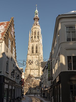
Grote Kerk (Breda)
Distance: Approx. 212 meters
Latitude and longitude: 51.589,4.775
The Grote Kerk or Onze-Lieve-Vrouwekerk (Church of Our Lady) is the most important monument and a landmark of Breda. The church is built in the Brabantine Gothic style. The tower of the church is 97 meters tall.

Koepelgevangenis (Breda)
Dutch panopticon prison built in 1886
Distance: Approx. 977 meters
Latitude and longitude: 51.59027778,4.78722222
The Koepelgevangenis is a former prison in Breda, Netherlands, constructed in 1886, best known as the prison where convicted World War II collaborators and Nazi war criminals were housed (including The Breda Four).
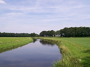
Aa of Weerijs
River in Belgium
Distance: Approx. 262 meters
Latitude and longitude: 51.5926,4.7714
The Aa of Weerijs (Dutch pronunciation: [ˌaː ʔɔf ˈʋeːrɛis], lit. 'Aa or Weerijs') is a river in Belgium and Netherlands, where it arises from the confluence of the Great Aa (in Wuustwezel) and the Small Aa (in Brecht). In Breda (which means the broad Aa) it is the river in the canals of this city.

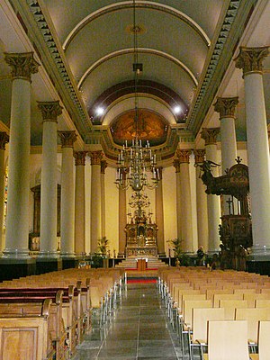
St. Anthony of Padua Cathedral, Breda
Church in Breda, Netherlands
Distance: Approx. 452 meters
Latitude and longitude: 51.5875,4.7775
The St. Anthony of Padua Cathedral (Dutch: Sint-Antoniuskathedraal) or Cathedral of St. Anthony, is the Roman Catholic cathedral of the Diocese of Breda, located in the city of Breda, in the Netherlands.
Siege of Breda (1813)
Distance: Approx. 1067 meters
Latitude and longitude: 51.58333306,4.78333306
The siege of Breda took place from 19 to 22 December 1813 and was a small yet important engagement between French and allied troops in the Liberation Wars. Breda was abandoned by its garrison early in December and occupied by a Russian force. With Breda being the strategic link between the French garrisons of Gorinchem and Antwerp, and to hold control over the main road between Breda and Antwerp, the French began a counterattack.
Weather in this IP's area
overcast clouds
15 Celsius
15 Celsius
14 Celsius
15 Celsius
1017 hPa
89 %
1017 hPa
1016 hPa
10000 meters
5.66 m/s
180 degree
100 %
08:12:10
18:39:08