Country:
 Netherlands
Region:
City:
Latitude and Longitude:
Time Zone:
Postal Code:
IP information under different IP Channel
ip-api
Country
Region
City
ASN
Time Zone
ISP
Blacklist
Proxy
Latitude
Longitude
Postal
Route
IPinfo
Country
Region
City
ASN
Time Zone
ISP
Blacklist
Proxy
Latitude
Longitude
Postal
Route
MaxMind
Country
Region
City
ASN
Time Zone
ISP
Blacklist
Proxy
Latitude
Longitude
Postal
Route
Luminati
Country
NLRegion
nb
City
shertogenbosch
ASN
Time Zone
Europe/Amsterdam
ISP
IP Visie Networking B.V.
Latitude
Longitude
Postal
db-ip
Country
Region
City
ASN
Time Zone
ISP
Blacklist
Proxy
Latitude
Longitude
Postal
Route
ipdata
Country
Region
City
ASN
Time Zone
ISP
Blacklist
Proxy
Latitude
Longitude
Postal
Route
Popular places and events near this IP address

Amsterdam University of Applied Sciences
University in The Netherlands
Distance: Approx. 808 meters
Latitude and longitude: 52.34569444,4.91616667
Amsterdam University of Applied Sciences (abbreviated as: AUAS; Dutch: Hogeschool van Amsterdam) is a large vocational university located in Amsterdam, Netherlands. The AUAS mainly offers bachelor's degree programmes, but also has a number of (professional) master's degree programmes. For students from the AUAS' international partner institutes it is possible to study at the AUAS as an exchange student.

Amsterdam Amstel station
Railway station in Amsterdam
Distance: Approx. 939 meters
Latitude and longitude: 52.34638889,4.91777778
Amsterdam Amstel (Dutch pronunciation: [ˌɑmstərˈdɑm ˈɑmstəl]; abbreviation: Asa) is a railway station in Amsterdam, Netherlands. The station opened in 1939. It is located to the southeast of Amsterdam Centraal in the borough of Amsterdam-Oost, near the Amstel river.
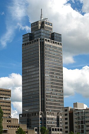
Rembrandt Tower
Office skyscraper in Amsterdam
Distance: Approx. 733 meters
Latitude and longitude: 52.3444,4.9167
Rembrandt Tower (Dutch: Rembrandttoren, pronounced [ˈrɛmbrɑnˌtoːrə(n)]) is an office skyscraper in Amsterdam. It has a height of 135 metres, 36 floors and it has a spire which extends its height to 150 metres. It was constructed from 1991 to 1994.
Amsteldorp
Neighborhood of Amsterdam in North Holland, Netherlands
Distance: Approx. 753 meters
Latitude and longitude: 52.33722222,4.91833333
Amsteldorp is a neighborhood of Amsterdam, Netherlands. The neighborhood dates from the 1920s but many houses were built in 1947–48 and in the 1950s. The Amstel Station is located within this area, which was built in 1939, and the tallest building in the neighbourhood is Rembrandt Tower, with a height of 150 metres.
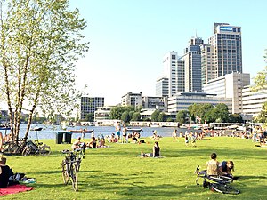
Omval
Neighbourhood of Amsterdam in North Holland, Netherlands
Distance: Approx. 749 meters
Latitude and longitude: 52.33388889,4.91222222
Omval is a neighbourhood situated on a peninsula on the eastern shore of the Amstel river in Amsterdam, Netherlands. It is situated south of the Weesperzijde neighbourhood and next to the Amsterdam Amstel railway station in the borough of Amsterdam-Oost. In the 1990s, it became the site of a major business district featuring the Rembrandt Tower, the tallest skyscraper in Amsterdam.
Rivierenbuurt
Neighbourhood of Amsterdam in North Holland, Netherlands
Distance: Approx. 932 meters
Latitude and longitude: 52.34527778,4.8975
Rivierenbuurt is a neighbourhood of Amsterdam, Netherlands. The neighbourhood is situated in the eastern part of the borough of Amsterdam-Zuid, bordered by the river Amstel to the east, the Boerenwetering canal in the west, the Amstelkanaal in the north and the A10 motorway in the south. In 2013, the Rivierenbuurt had approximately 28,400 residents.

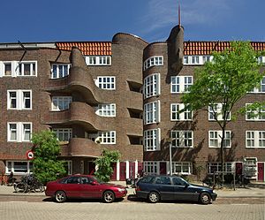
Zomerdijkstraat
Street in Amsterdam
Distance: Approx. 414 meters
Latitude and longitude: 52.3425,4.90361111
The Zomerdijkstraat is a small street in the Amsterdam neighborhood Rivierenbuurt, consisting of apartment buildings and a hallmark building, the studio complex at the Zomerdijkstraat. A classified monument, the building was designed by the functionalist architects Piet Zanstra, J.H.L. Giesen en K.L. Sijmons. The building is a pivotal work in Dutch architecture of the early thirties.
NIPO
Distance: Approx. 494 meters
Latitude and longitude: 52.34416667,4.91166667
NIPO, previously named NIPO Software, is a long term provider to the professional market research industry for online, CAPI and CATI surveys. NIPO is a major worldwide Market Research software provider. NIPO's main offering is centered around the Nfield platform, hosted in a SaaS model on Microsoft Azure cloud servers.

Spaklerweg metro station
Amsterdam Metro station in the Netherlands
Distance: Approx. 846 meters
Latitude and longitude: 52.34027778,4.92083333
Spaklerweg is an Amsterdam Metro station in the industrial area Overamstel of Amsterdam, Netherlands. The station opened in 1982 and is served by 3 lines, the 51 (Amsterdam Centraal - Isolatorweg), 53 (Amsterdam Centraal - Gaasperplas) and 54 (Amsterdam Centraal - Gein). The metro station is only accessible with an OV-chipkaart or GVB Travel Pass.

Zorgvlied (cemetery)
Dutch cemetery
Distance: Approx. 757 meters
Latitude and longitude: 52.33555556,4.90027778
Zorgvlied (Dutch pronunciation: [ˈzɔr(ə)xflit]) is a cemetery on the Amsteldijk in Amsterdam, the Netherlands, on the left bank of the river Amstel. The cemetery was opened in 1870 by the city of Amstelveen which still owns and operates it, though since 1896 (when city lines were redrawn) it is located within the boundaries of the city of Amsterdam. One of the country's best-known cemeteries, it is notable for the large number of celebrities, especially from the literary and theater worlds, buried there.

Mondriaan Tower
Distance: Approx. 755 meters
Latitude and longitude: 52.344,4.9176
The Mondriaan Tower (Dutch: Mondriaantoren) is a skyscraper located at Amstelplein 6-8, near the Amstel river, in Amsterdam, Netherlands. The modern office building is 120 meters high, has 30 office floors and an underlying parking garage. Mondriaan Tower was completed in 2002.

Fusilladeplaats Rozenoord
World War II memorial in Amsterdam
Distance: Approx. 968 meters
Latitude and longitude: 52.33388889,4.89861111
Fusilladeplaats Rozenoord is a World War II memorial in the Dutch city of Amsterdam. 'Fusilladeplaats' might be translated into English as 'firing squad place'. 'Rozenoord' was originally a rose garden, whose name was adopted during the 1930s by a teahouse by the Amsteldijk, a dyke in Amsterdam.
Weather in this IP's area
broken clouds
15 Celsius
14 Celsius
14 Celsius
15 Celsius
1016 hPa
85 %
1016 hPa
1015 hPa
10000 meters
5.66 m/s
180 degree
75 %
08:12:59
18:37:15