Country:
 Netherlands
Region:
City:
Latitude and Longitude:
Time Zone:
Postal Code:
IP information under different IP Channel
ip-api
Country
Region
City
ASN
Time Zone
ISP
Blacklist
Proxy
Latitude
Longitude
Postal
Route
IPinfo
Country
Region
City
ASN
Time Zone
ISP
Blacklist
Proxy
Latitude
Longitude
Postal
Route
MaxMind
Country
Region
City
ASN
Time Zone
ISP
Blacklist
Proxy
Latitude
Longitude
Postal
Route
Luminati
Country
NLRegion
nb
City
shertogenbosch
ASN
Time Zone
Europe/Amsterdam
ISP
IP Visie Networking B.V.
Latitude
Longitude
Postal
db-ip
Country
Region
City
ASN
Time Zone
ISP
Blacklist
Proxy
Latitude
Longitude
Postal
Route
ipdata
Country
Region
City
ASN
Time Zone
ISP
Blacklist
Proxy
Latitude
Longitude
Postal
Route
Popular places and events near this IP address
Abcoude
Town and former municipality in Utrecht, Netherlands
Distance: Approx. 2387 meters
Latitude and longitude: 52.27,4.97
Abcoude (Dutch pronunciation: [ɑpˈkʌudə] ) is a town and former municipality in the Netherlands, in the province of Utrecht. Since 2011 it has been part of the municipality of De Ronde Venen.

Amsterdam-Zuidoost
Borough of Amsterdam in North Holland, Netherlands
Distance: Approx. 2356 meters
Latitude and longitude: 52.31055556,4.97333333
Amsterdam-Zuidoost (Dutch pronunciation: [ˌɑmstərdɑmˈzœyt.oːst]; "Amsterdam-Southeast") is a borough (stadsdeel) of Amsterdam, Netherlands. It consists of four residential neighborhoods—Bijlmermeer, Venserpolder, Gaasperdam and Driemond—as well as the Amstel III/Bullewijk Business Park and the Amsterdam Arena entertainment and shopping district. Geographically, Amsterdam-Zuidoost is an exclave of Amsterdam as it does not border any of the other boroughs.

Driemond
Village in North Holland, Netherlands
Distance: Approx. 2592 meters
Latitude and longitude: 52.3,5.01666667
Driemond is a village in the Dutch province of North Holland. It is a part of Weesp, an Urban area in the municipality of Amsterdam, Netherlands.
Abcoude-Proostdij
Distance: Approx. 2148 meters
Latitude and longitude: 52.27083333,4.98055556
Abcoude-Proostdij (sometimes called "Abcoude-Proosdij" or "Abcoude-Proostdij en Aasdom") is a former municipality in the Dutch province of Utrecht. Abcoude-Proostdij covered the northern part of the current municipality of Abcoude, including the village of Abcoude itself. Abcoude-Proostdij was a heerlijkheid (manor) owned by the chapter of the St.

Academic Medical Center (Amsterdam)
Hospital in Amsterdam, Netherlands
Distance: Approx. 1750 meters
Latitude and longitude: 52.29444444,4.9575
The Academic Medical Center (Dutch: Academisch Medisch Centrum), or AMC, was the university hospital affiliated with the University of Amsterdam. After merging with the VU University Medical Center, it now operates as the Amsterdam University Medical Center, a single organization with two locations, affiliated with two universities. It was one of the largest and leading hospitals of the Netherlands, located in the Bijlmer neighborhood in the most south-eastern part of the city of Amsterdam.

Gaasperplas
Artificial lake in Netherlands
Distance: Approx. 1837 meters
Latitude and longitude: 52.30555556,4.99166667
Gaasperplas is an artificial lake used for recreational purposes south-east of Amsterdam in the Netherlands. Gaasperplas was created with the extraction of sand for the construction of the Bijlmer. At its deepest the lake is 35 metres deep.

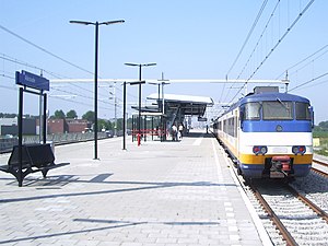
Amsterdam Holendrecht station
Metro and railway station in Amsterdam
Distance: Approx. 1721 meters
Latitude and longitude: 52.2975,4.96
Amsterdam Holendrecht is a railway and metro station in Amsterdam, Netherlands. The station opened on 14 December 2008. Before that date Holendrecht was just a station on the Amsterdam Metro network which was opened on 16 October 1977 and is now served by two lines, the 50 and 54.
Abcoude railway station
Railway station in Abcoude, the Netherlands
Distance: Approx. 1743 meters
Latitude and longitude: 52.27444444,4.98222222
Abcoude is a railway station located in Abcoude, Netherlands.
Gaasperdam
Neighborhood of Amsterdam in North Holland, Netherlands
Distance: Approx. 2125 meters
Latitude and longitude: 52.30805556,4.99277778
Gaasperdam is a neighborhood of Amsterdam, Netherlands in the Zuidoost (southeastern) borough of the city.

Reigersbos metro station
Metro station in Amsterdam, Netherlands
Distance: Approx. 805 meters
Latitude and longitude: 52.29555556,4.97444444
Reigersbos is an Amsterdam Metro station in the Gaasperdam area of Amsterdam, Netherlands. The station opened in 1982 and is served by 2 lines, the 50 (Isolatorweg - Gein) and 54 (Amsterdam Centraal - Gein). The metro station is only accessible with an OV-chipkaart, GVB Travel Pass or paying by cash.

Gein metro station
Metro station in Amsterdam, Netherlands
Distance: Approx. 846 meters
Latitude and longitude: 52.29638889,4.98916667
Gein is an Amsterdam Metro station in the Gaasperdam area of Amsterdam, Netherlands. The station opened in 1982 and is served by 2 lines, the 50 (Isolatorweg - Gein) and 54 (Amsterdam Centraal - Gein). The metro station is only accessible with an OV-chipkaart or GVB Travel Pass.

Gaasperplas metro station
Metro station in Amsterdam
Distance: Approx. 2344 meters
Latitude and longitude: 52.31111111,4.98444444
Gaasperplas is an Amsterdam Metro station in Amsterdam, Netherlands.
Weather in this IP's area
broken clouds
15 Celsius
15 Celsius
14 Celsius
15 Celsius
1016 hPa
90 %
1016 hPa
1016 hPa
10000 meters
5.66 m/s
180 degree
75 %
08:12:35
18:37:02