Country:
 Netherlands
Region:
City:
Latitude and Longitude:
Time Zone:
Postal Code:
IP information under different IP Channel
ip-api
Country
Region
City
ASN
Time Zone
ISP
Blacklist
Proxy
Latitude
Longitude
Postal
Route
IPinfo
Country
Region
City
ASN
Time Zone
ISP
Blacklist
Proxy
Latitude
Longitude
Postal
Route
MaxMind
Country
Region
City
ASN
Time Zone
ISP
Blacklist
Proxy
Latitude
Longitude
Postal
Route
Luminati
Country
NLRegion
nh
City
amsterdam
ASN
Time Zone
Europe/Amsterdam
ISP
IP Visie Networking B.V.
Latitude
Longitude
Postal
db-ip
Country
Region
City
ASN
Time Zone
ISP
Blacklist
Proxy
Latitude
Longitude
Postal
Route
ipdata
Country
Region
City
ASN
Time Zone
ISP
Blacklist
Proxy
Latitude
Longitude
Postal
Route
Popular places and events near this IP address

Amsterdam Centraal station
Railway station in the Netherlands
Distance: Approx. 1023 meters
Latitude and longitude: 52.37833333,4.9
Amsterdam Centraal station (Dutch: Station Amsterdam Centraal [staːˈʃɔn ˌɑmstərˈdɑm sɛnˈtraːl]; abbreviation: Asd) is the largest railway station in Amsterdam, North Holland, the Netherlands. A major international railway hub, it is used by 192,000 passengers a day, making it the second busiest railway station in the country after Utrecht Centraal and the most visited Rijksmonument of the Netherlands. National and international railway services at Amsterdam Centraal are provided by NS (Nederlandse Spoorwegen), the principal rail operator in the Netherlands.

Amsterdam-Noord
Borough of Amsterdam in North Holland, Netherlands
Distance: Approx. 920 meters
Latitude and longitude: 52.39111111,4.91833333
Amsterdam-Noord (Dutch pronunciation: [ˌɑmstərdɑmˈnoːrt]; English: North Amsterdam) is a borough of Amsterdam, Netherlands with a population of about 90,000. The IJ, the body of water which separates it from Amsterdam-Centrum and the rest of the city, is situated southwest of Amsterdam-Noord. The borough, which has an area of 49.01 km2 (18.92 square miles), borders the municipalities of Zaanstad, Oostzaan, Landsmeer and Waterland to the north, all part of the province of North Holland like Amsterdam.

Muziekgebouw aan 't IJ
Distance: Approx. 1001 meters
Latitude and longitude: 52.37813889,4.913
Muziekgebouw aan 't IJ (English: "Music Building on the IJ") is the main concert hall for contemporary classical music on the IJ in Amsterdam, Netherlands. The building opened in 2005 and is located above the IJtunnel, a ten-minute walk from Amsterdam Centraal station.

Bimhuis
Concert hall in Amsterdam
Distance: Approx. 1015 meters
Latitude and longitude: 52.378,4.913
The Bimhuis is a concert hall for jazz and improvised music in Amsterdam. With an average of 150 performances a year the Bimhuis is the main stage for these musical genres in the Netherlands. In 2017 it was also a host for the 17th edition of the Sonic Acts Festival.

EYE Film Institute Netherlands
Film archive, National museum, Art museum, History museum in Amsterdam, the Netherlands
Distance: Approx. 500 meters
Latitude and longitude: 52.384411,4.900594
Eye Filmmuseum is a film archive, museum, and cinema in Amsterdam that preserves and presents both Dutch and foreign films screened in the Netherlands.

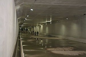
IJtunnel
Distance: Approx. 783 meters
Latitude and longitude: 52.37972222,4.91083333
The IJtunnel, opened on 30 October 1968, is an automobile tunnel under the IJ that connects the centre of Amsterdam with Amsterdam-Noord. The tunnel is part of a route across Amsterdam that connects the Ringweg North with the Ringweg South near Duivendrecht, via Nieuwe Leeuwarderweg, Valkenburgerstraat, Weesperstraat, Wibautstraat and Gooiseweg (S112). The total length of the tunnel, including on- and off-ramps, is 1682 metres.

Hyperion Lyceum
School
Distance: Approx. 125 meters
Latitude and longitude: 52.38564444,4.90584167
The Hyperion Lyceum is a secondary school in Amsterdam which offers both gymnasium and atheneum streams. It opened in fall 2011; since 2012 it has been located in Overhoeks in Amsterdam-Noord, in a temporary modular building designed for it by Burton Hamfelt Architectuur. The school is distinguished by using cross-curricular projects for some of the instruction, and offers special courses in great thinkers, lifestyle informatics, drama, and logic and rhetoric.
3D Print Canal House
Distance: Approx. 827 meters
Latitude and longitude: 52.3932,4.9023
The 3D Print Canal House is a three-year, publicly accessible "Research & Design by Doing" project in which an international team of partners from various sectors works together on 3D printing a canal house in Amsterdam. By building the house, all parties research the possibilities of 3D printing architecture and form connections between design, science, culture, building, software, communities and the city. The project serves as both an exhibition of 3D printing technology, as well as a research site into 3D printing architecture.
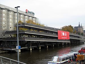
Fietsflat
Bicycle parking facility in Amsterdam
Distance: Approx. 1057 meters
Latitude and longitude: 52.37926,4.896941
The Fietsflat is a 3-storey free-to-use public bicycle parking facility in Amsterdam. It is located on Stationseiland island next to Amsterdam Central Station and can accommodate 2500 bicycles. The name is derived from fiets (bicycle) and flat, an originally English word which the Dutch use to denote multi-level apartment complexes.

Noorderpark metro station
Station on the North–South Line of the Amsterdam Metro
Distance: Approx. 869 meters
Latitude and longitude: 52.38916667,4.91916667
Noorderpark is a station on the Amsterdam Metro's Route 52 (North–South Line) in Amsterdam, Netherlands. The line and station were opened on 22 July 2018.
Sixhaven metro station
Metro station in Amsterdam, Netherlands
Distance: Approx. 474 meters
Latitude and longitude: 52.38222222,4.90583333
Sixhaven is a cancelled underground metro station in Amsterdam-Noord, Netherlands, located on the route of metro line 52 of the Amsterdam Metro. The station was postponed in 2003 due to high costs and low passenger expectancy. The section of the tunnel where the station was proposed was made larger to allow for the station to be constructed at a later date.
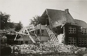
Allied bombings of Amsterdam-Noord
Part of World War II
Distance: Approx. 1053 meters
Latitude and longitude: 52.39583333,4.90833333
The Allied bombings of Amsterdam-Noord took place in July 1943 during the German occupation of the Netherlands in World War II. Three strategic bombing attacks by Allied Forces were aimed at the former Fokker Aircraft Factory in the northern part of Amsterdam, which was of interest as the factory was confiscated by the Nazis and employees were forced to produce aircraft for the Luftwaffe. However, only 7 out of the 326 bombs from these three airstrikes hit their target, while the others fell on the surrounding residential area, resulting in the loss of more than 206 lives in total. The attacks were the most damaging and deadly bombardment of Amsterdam during the Second World War, and the most disastrous airstrike the city has ever endured.
Weather in this IP's area
few clouds
20 Celsius
20 Celsius
19 Celsius
21 Celsius
1006 hPa
65 %
1006 hPa
1005 hPa
10000 meters
4.12 m/s
170 degree
20 %
07:03:43
20:12:34