Country:
 Spain
SpainRegion:
City:
Latitude and Longitude:
Time Zone:
Postal Code:
IP information under different IP Channel
ip-api
Country
Region
City
ASN
Time Zone
ISP
Blacklist
Proxy
Latitude
Longitude
Postal
Route
IPinfo
Country
Region
City
ASN
Time Zone
ISP
Blacklist
Proxy
Latitude
Longitude
Postal
Route
MaxMind
Country
Region
City
ASN
Time Zone
ISP
Blacklist
Proxy
Latitude
Longitude
Postal
Route
Luminati
Country
ESASN
Time Zone
Europe/Madrid
ISP
Avatel Telecom, SA
Latitude
Longitude
Postal
db-ip
Country
Region
City
ASN
Time Zone
ISP
Blacklist
Proxy
Latitude
Longitude
Postal
Route
ipdata
Country
Region
City
ASN
Time Zone
ISP
Blacklist
Proxy
Latitude
Longitude
Postal
Route
Popular places and events near this IP address

Axarquía
Comarca in Andalucía, Spain
Distance: Approx. 7969 meters
Latitude and longitude: 36.83333333,-4.16666667
Axarquía (Spanish pronunciation: [axaɾˈki.a]) is a comarca of Andalusia in southern Spain. It is the wedge-shaped area east of Málaga. Its name is traced back to Arabic الشرقية (aš-Šarqiyya, meaning "the eastern [region]").

Vélez-Málaga
Place in Málaga, Spain
Distance: Approx. 552 meters
Latitude and longitude: 36.78333333,-4.1
Vélez-Málaga (Spanish pronunciation: [ˈbeleθ ˈmalaɣa]) is a municipality and the capital of the Axarquía comarca in the province of Málaga, in the Spanish autonomous community of Andalusia. It is the most important city in the comarca. Locally it is referred to as Vélez.

Algarrobo, Spain
Municipality and town in Andalucía, Spain
Distance: Approx. 6635 meters
Latitude and longitude: 36.76666667,-4.03333333
Algarrobo is a town and municipality in the province of Málaga, part of the autonomous community of Andalusia in southern Spain. The municipality is situated in the coastal area of La Axarquía, 32 kilometers from the city of Málaga. It is bordered on the north by the municipality of Arenas and Sayalonga, to the east and west by Vélez-Málaga and to the south by the Mediterranean Sea.

Benamargosa
Place in Andalusia, Spain
Distance: Approx. 9050 meters
Latitude and longitude: 36.83333333,-4.18333333
Benamargosa is a town and municipality in the region of La Axarquía in the province of Málaga, part of the autonomous community of Andalusia in southern Spain. The municipality is situated approximately 11 kilometres from Vélez Málaga and 46 from the provincial capital. It has a population of approximately 1,500 residents.

Benamocarra
Municipality in Andalusia, Spain
Distance: Approx. 4488 meters
Latitude and longitude: 36.8,-4.15
Benamocarra is a town and municipality in the Province of Málaga, part of the autonomous community of Andalusia in southern Spain. The municipality is situated approximately 5 kilometres from Vélez-Málaga and 41 from Málaga, the provincial capital. It has a population of approximately 3,000 residents.

Sayalonga
Place in Andalusia, Spain
Distance: Approx. 8197 meters
Latitude and longitude: 36.8,-4.01666667
Sayalonga is a town and municipality in the province of Málaga, part of the autonomous community of Andalusia in southern Spain. It belongs to the comarca of La Axarquía. The municipality is situated approximately 38 kilometres from the capital of Málaga and 12 kilometres from Vélez Málaga.

Torre del Mar
Locality on the southern coast of Spain
Distance: Approx. 3988 meters
Latitude and longitude: 36.75,-4.08333333
Torre del Mar is a locality on the southern coast of Spain, part of the municipality of Vélez-Málaga, Axarquía, located in the province of Málaga. It is a popular summer tourist resort for Spanish people.

Arenas, Málaga
Municipality in Andalusia, Spain
Distance: Approx. 6658 meters
Latitude and longitude: 36.81583333,-4.04472222
Arenas is a municipality in the province of Málaga located in the autonomous community of Andalusia in southern Spain. It is situated in the comarca of Axarquía. By way of road it is located 12 kilometers from Vélez-Málaga, 50 km from Málaga and 577 km from Madrid.

Los Toscanos
Distance: Approx. 4586 meters
Latitude and longitude: 36.74083333,-4.11638889
Toscanos (in Spanish Cortijo de Los Toscanos) is the name of an Andalusian cortijo near Vélez-Málaga in southern Spain, and was the location of an early Phoenician settlement. The Phoenician name of the settlement is unknown.
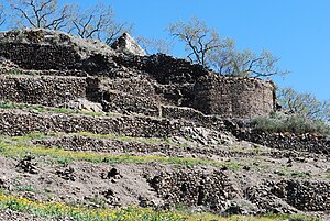
Bentomiz Castle
Distance: Approx. 6053 meters
Latitude and longitude: 36.804028,-4.043956
Bentomiz Castle is an ancient Moorish fortress built on a hill near the village of Arenas in the province of Málaga. It sits at a height of 711 metres (2,333 ft), and lies to the northeast of Vélez-Málaga. The castle site is thought to have been occupied by the Phoenicians, Greeks and Romans, although it is not clear which parts of the ruins date to which period.

San Juan Bautista, Vélez-Málaga
Historic site in Vélez-Málaga, Spain
Distance: Approx. 333 meters
Latitude and longitude: 36.7826,-4.1023
The Iglesia de San Juan Bautista or the Church of San Juan Bautista is a Roman Catholic church dedicated to John the Baptist, in Vélez-Málaga, in the province of Málaga, Spain. It is an art-historical monument that, over time, has undergone multiple architectural changes to its structure based on existing trends. The original church dates from 1487 and was built in the Gothic-Mudejar style.

Caleta de Velez
Place in Málaga, Spain
Distance: Approx. 7269 meters
Latitude and longitude: 36.7333,-4.05
Caleta de Vélez is a village in the Spanish province of Málaga, Andalusia. It belongs to Vélez-Málaga and it is in Axarquía. It is 35 kilometers away from Málaga.
Weather in this IP's area
overcast clouds
18 Celsius
18 Celsius
18 Celsius
20 Celsius
1021 hPa
76 %
1021 hPa
1016 hPa
10000 meters
0.44 m/s
0.68 m/s
12 degree
92 %
08:28:35
19:33:24