Country:
 Great Britain
Region:
City:
Latitude and Longitude:
Time Zone:
Postal Code:
IP information under different IP Channel
ip-api
Country
Region
City
ASN
Time Zone
ISP
Blacklist
Proxy
Latitude
Longitude
Postal
Route
IPinfo
Country
Region
City
ASN
Time Zone
ISP
Blacklist
Proxy
Latitude
Longitude
Postal
Route
MaxMind
Country
Region
City
ASN
Time Zone
ISP
Blacklist
Proxy
Latitude
Longitude
Postal
Route
Luminati
Country
GBASN
Time Zone
Europe/London
ISP
Barclays Bank PLC
Latitude
Longitude
Postal
db-ip
Country
Region
City
ASN
Time Zone
ISP
Blacklist
Proxy
Latitude
Longitude
Postal
Route
ipdata
Country
Region
City
ASN
Time Zone
ISP
Blacklist
Proxy
Latitude
Longitude
Postal
Route
Popular places and events near this IP address

London Docklands
Area by the Thames in London, England
Distance: Approx. 229 meters
Latitude and longitude: 51.505,-0.01805556
London Docklands is the riverfront and former docks in London. It is located in inner east and southeast London, in the boroughs of Southwark, Tower Hamlets, Lewisham, Newham and Greenwich. The docks were formerly part of the Port of London, at one time the world's largest port.

8 Canada Square
Skyscraper in London, England
Distance: Approx. 190 meters
Latitude and longitude: 51.50527778,-0.01738889
8 Canada Square is a 45 floor skyscraper in Canary Wharf, London. The building is the global headquarters of HSBC Holdings.

West India Docks
Historic dock site, now part of Canary Wharf area.
Distance: Approx. 226 meters
Latitude and longitude: 51.50347,-0.01722
The West India Docks are a series of three docks, quaysides, and warehouses built to import goods from, and export goods and occasionally passengers to the British West Indies. Located on the Isle of Dogs in London, the first dock opened in 1802. Following their commercial closure in 1980, the Canary Wharf development was built around the wet docks by narrowing some of their broadest tracts.

Citigroup Centre (London)
Building complex in London, England
Distance: Approx. 229 meters
Latitude and longitude: 51.504,-0.01780556
The Citigroup Centre is a building complex in London. It houses Citigroup's EMEA headquarters and is located in Canary Wharf in the city's Docklands. The centre provides 170,000 square metres (1,800,000 sq ft) of floor space across two buildings - 33 Canada Square and 25 Canada Square, and houses the bulk of Citi's UK employee base.

Billingsgate Fish Market
Fish market in Poplar in London, England
Distance: Approx. 182 meters
Latitude and longitude: 51.50638889,-0.01416667
Billingsgate Fish Market is located in Poplar in London. It is the United Kingdom's largest inland fish market. It takes its name from Billingsgate, a ward in the south-east corner of the City of London, where the riverside market was originally established.
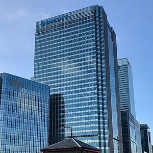
One Churchill Place
156 m tall skyscraper with 32 floors, serving as the headquarters of Barclays Bank
Distance: Approx. 94 meters
Latitude and longitude: 51.5055,-0.014
One Churchill Place is a 156 m tall skyscraper with 32 floors, serving as the headquarters of Barclays Bank. It is in the Docklands area of London Borough of Tower Hamlets in Canary Wharf. The building is the 13th-tallest office block in the United Kingdom and the sixth tallest building in the Docklands.

10 Upper Bank Street
32-story commercial skyscraper located in Canary Wharf, in the Docklands area of London
Distance: Approx. 252 meters
Latitude and longitude: 51.50277778,-0.01638889
10 Upper Bank Street is a 32-story commercial skyscraper located in Canary Wharf, in the Docklands area of London. It was completed in 2003 and is 151 m (495 ft) tall. It was designed by the architect Kohn Pedersen Fox and built by Canary Wharf Contractors.
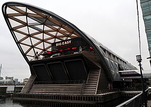
Canary Wharf railway station
National rail station in East London, England
Distance: Approx. 161 meters
Latitude and longitude: 51.5061,-0.01578
Canary Wharf is an Elizabeth line station in Canary Wharf in East London, England. The station forms an artificial island in the West India Docks (North Dock). The five upper levels of the station are a mixed-use development known as Crossrail Place.
South Dock railway station
Former railway station in England
Distance: Approx. 277 meters
Latitude and longitude: 51.5026,-0.0129
South Dock was a railway station on the Isle of Dogs in east London. It was between Millwall Junction and Millwall Docks on the Millwall Extension Railway (MER) branch of the London and Blackwall Railway (LBR) which opened to goods traffic on 18 December 1871 and to passenger services on 29 July 1872. The station was on the northern side of the South Dock of the West India Docks, near the eastern end.

20 Canada Square
Office building in Canary Wharf, London, England
Distance: Approx. 167 meters
Latitude and longitude: 51.50388889,-0.01666667
20 Canada Square is an office building located in the Canary Wharf section of London. Currently, 20 Canada Square is vacant. The building is divided into twelve floors.

25 Churchill Place
Skyscraper in East London
Distance: Approx. 112 meters
Latitude and longitude: 51.5037983,-0.0148581
25 Churchill Place is a 118 metres (387 ft) tall skyscraper in the eastern part of the London financial district Canary Wharf. It was built in 2014 and has 23 storeys. The building was developed by Canary Wharf Group and designed by Kohn Pedersen Fox.
Crossrail Place
Structure in the West India Docks, Canary Wharf, London
Distance: Approx. 239 meters
Latitude and longitude: 51.5061,-0.0175
Crossrail Place is a complex built in the North Dock of the West India Docks in London's Canary Wharf, as part of the railway project Crossrail. It contains Canary Wharf railway station and was partly opened on 1 May 2015. Architect Magazine described Crossrail Place as an "enormous, ship-like building", and its roof is the largest timber project in the United Kingdom.
Weather in this IP's area
few clouds
13 Celsius
13 Celsius
12 Celsius
14 Celsius
1013 hPa
84 %
1013 hPa
1011 hPa
10000 meters
5.14 m/s
190 degree
20 %
07:29:28
18:00:30