157.25.132.218 - IP Lookup: Free IP Address Lookup, Postal Code Lookup, IP Location Lookup, IP ASN, Public IP
Country:
Region:
City:
Location:
Time Zone:
Postal Code:
IP information under different IP Channel
ip-api
Country
Region
City
ASN
Time Zone
ISP
Blacklist
Proxy
Latitude
Longitude
Postal
Route
Luminati
Country
Region
14
City
radom
ASN
Time Zone
Europe/Warsaw
ISP
SGK Projekt sp. z o.o. spolka komandytowa
Latitude
Longitude
Postal
IPinfo
Country
Region
City
ASN
Time Zone
ISP
Blacklist
Proxy
Latitude
Longitude
Postal
Route
IP2Location
157.25.132.218Country
Region
lodzkie
City
tomaszow mazowiecki
Time Zone
Europe/Warsaw
ISP
Language
User-Agent
Latitude
Longitude
Postal
db-ip
Country
Region
City
ASN
Time Zone
ISP
Blacklist
Proxy
Latitude
Longitude
Postal
Route
ipdata
Country
Region
City
ASN
Time Zone
ISP
Blacklist
Proxy
Latitude
Longitude
Postal
Route
Popular places and events near this IP address

Tomaszów Mazowiecki
City in Poland
Distance: Approx. 1722 meters
Latitude and longitude: 51.51666667,20.01666667
Tomaszów Mazowiecki (pronounced [tɔˈmaʂuf mazɔˈvjɛt͡skʲi] , Yiddish: טאָמעשעוו or Tomashuv) is a city in central Poland with 60,529 inhabitants (2021). It is the fourth most populous city in the Łódź Voivodeship and the second with free public transport. It is the seat of Tomaszów County.
Battle of Tomaszów Mazowiecki
Distance: Approx. 603 meters
Latitude and longitude: 51.533333,20.016667
The battle of Tomaszów Mazowiecki (Polish: Bitwa pod Tomaszowem Mazowieckim) was fought on 6 September 1939 near the town of Tomaszów Mazowiecki, Second Polish Republic, during the invasion of Poland. The area was defended by Polish 13th Infantry Division under Col. Władysław Kaliński, and Germany's assault was carried by two armored divisions of the 16th Panzer Corps.

Tomaszów County, Łódź Voivodeship
County in Łódź Voivodeship, Poland
Distance: Approx. 1722 meters
Latitude and longitude: 51.51666667,20.01666667
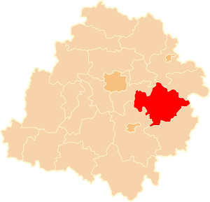
Tomaszów County (Polish: powiat tomaszowski) is a county in Łódź Voivodeship, central Poland. It came into being on January 1, 1999, as a result of the Polish local government reforms passed in 1998. Its administrative seat and only town is Tomaszów Mazowiecki, which lies 49 kilometres (30 mi) south-east of the regional capital Łódź.
Gmina Tomaszów Mazowiecki
Gmina in Łódź Voivodeship, Poland
Distance: Approx. 1722 meters
Latitude and longitude: 51.51666667,20.01666667
Gmina Tomaszów Mazowiecki is a rural gmina (administrative district) in Tomaszów Mazowiecki County, Łódź Voivodeship, in central Poland. Its seat is the town of Tomaszów Mazowiecki, although the town is not part of the territory of the gmina. The gmina covers an area of 151.3 square kilometres (58.4 sq mi), and as of 2006 its total population is 9,826.
Dąbrowa, Gmina Tomaszów Mazowiecki
Village in Łódź Voivodeship, Poland
Distance: Approx. 2847 meters
Latitude and longitude: 51.51972222,19.97194444
Dąbrowa [dɔmˈbrɔva] is a village in the administrative district of Gmina Tomaszów Mazowiecki, within Tomaszów Mazowiecki County, Łódź Voivodeship, in central Poland. It lies approximately 4 kilometres (2 mi) west of Tomaszów Mazowiecki and 46 km (29 mi) south-east of the regional capital Łódź.
Komorów, Tomaszów Mazowiecki County
Village in Łódź Voivodeship, Poland
Distance: Approx. 3533 meters
Latitude and longitude: 51.55722222,19.97916667
Komorów [kɔˈmɔruf] is a village in the administrative district of Gmina Tomaszów Mazowiecki, within Tomaszów Mazowiecki County, Łódź Voivodeship, in central Poland. It lies approximately 6 kilometres (4 mi) north-west of Tomaszów Mazowiecki and 44 km (27 mi) south-east of the regional capital Łódź.
Niebrów
Village in Łódź Voivodeship, Poland
Distance: Approx. 2817 meters
Latitude and longitude: 51.54048889,19.97069722
Niebrów [ˈɲɛbruf] is a village in the administrative district of Gmina Tomaszów Mazowiecki, within Tomaszów Mazowiecki County, Łódź Voivodeship, in central Poland. It lies approximately 5 kilometres (3 mi) north-west of Tomaszów Mazowiecki and 45 km (28 mi) south-east of the regional capital Łódź.
Zaborów Pierwszy
Village in Łódź Voivodeship, Poland
Distance: Approx. 3572 meters
Latitude and longitude: 51.55,19.96666667
Zaborów Pierwszy [zaˈbɔruf ˈpjɛrfʂɨ] is a village in the administrative district of Gmina Tomaszów Mazowiecki, within Tomaszów Mazowiecki County, Łódź Voivodeship, in central Poland. It lies approximately 6 kilometres (4 mi) north-west of Tomaszów Mazowiecki and 44 km (27 mi) south-east of the regional capital Łódź.
Pilica River Skansen
Distance: Approx. 2343 meters
Latitude and longitude: 51.5151,20.0302
The open-air museum of Pilica river is the first heritage park in Poland dedicated to a river. It is located near the Pilica river in the town of Tomaszów Mazowiecki, Łódź Voivodeship. It was created in 2000.

Niebieskie Źródła Nature Reserve
Protected area in Tomaszów Mazowiecki, Poland
Distance: Approx. 2531 meters
Latitude and longitude: 51.51194444,20.02777778
The Niebieskie Źródła Nature Reserve, or Blue Springs in English, is a nature reserve in Poland in the city of Tomaszów Mazowiecki. It is famous for two pools fed by an underground spring which seem to "shimmer" or "ripple" at the bottom due to the action of entering water. The reserve gets its name from the unusual colour of the water.

Ice Arena Tomaszów Mazowiecki
Distance: Approx. 1742 meters
Latitude and longitude: 51.52,20.026
Ice Arena Tomaszów Mazowiecki is Poland's first year-round ice skating rink that serves for speed skating, figure skating, ice hockey, short track and roller skating. It is located near Pilica River in Tomaszów Mazowiecki, 10 kilometers away from the Olympic Sports Centre in Spała, Poland. It was built between 2016 and 2017.

Nagórzyckie Grottoes in Tomaszów Mazowiecki
Distance: Approx. 3729 meters
Latitude and longitude: 51.49888889,19.995
The Nagórzyckie Grottoes in Tomaszów Mazowiecki (pol. Groty Nagórzyckie w Tomaszowie Mazowieckim. Also known as: Nagórzyckie Caves) – the former underground quartz sand mine in the southern part of Tomaszów Mazowiecki, Poland.
Weather in this IP's area
overcast clouds
-4 Celsius
-9 Celsius
-4 Celsius
-4 Celsius
1037 hPa
93 %
1037 hPa
1012 hPa
3185 meters
3.66 m/s
8.64 m/s
8 degree
96 %
