Country:
 Canada
Region:
City:
Latitude and Longitude:
Time Zone:
Postal Code:
IP information under different IP Channel
ip-api
Country
Region
City
ASN
Time Zone
ISP
Blacklist
Proxy
Latitude
Longitude
Postal
Route
IPinfo
Country
Region
City
ASN
Time Zone
ISP
Blacklist
Proxy
Latitude
Longitude
Postal
Route
MaxMind
Country
Region
City
ASN
Time Zone
ISP
Blacklist
Proxy
Latitude
Longitude
Postal
Route
Luminati
Country
CARegion
qc
City
saintignacedeloyola
ASN
Time Zone
America/Toronto
ISP
CC-3272
Latitude
Longitude
Postal
db-ip
Country
Region
City
ASN
Time Zone
ISP
Blacklist
Proxy
Latitude
Longitude
Postal
Route
ipdata
Country
Region
City
ASN
Time Zone
ISP
Blacklist
Proxy
Latitude
Longitude
Postal
Route
Popular places and events near this IP address

Richelieu River
River in Quebec, Canada; right tributary of the St. Lawrence
Distance: Approx. 1980 meters
Latitude and longitude: 46.04694444,-73.12
The Richelieu River (French: [ʁiʃ(ə)ljø] ) is a river of Quebec, Canada, and a major right-bank tributary of the St. Lawrence River. It rises at Lake Champlain, from which it flows northward through Quebec and empties into the St.
Berthierville
City in Quebec, Canada
Distance: Approx. 4980 meters
Latitude and longitude: 46.08333333,-73.18333333
Berthierville ()(also called Berthier-en-haut, and legally called Berthier before 1942) is a town located between Montreal and Trois-Rivières on the north shore of the Saint Lawrence River in Quebec, Canada. Berthierville is the seat of D'Autray Regional County Municipality, and is served by Autoroute 40, and is the junction of Routes 138 and 158. It is surrounded by the parish municipality of Sainte-Geneviève-de-Berthier.

Sorel-Tracy
City in Quebec, Canada
Distance: Approx. 3516 meters
Latitude and longitude: 46.03333333,-73.11666667
Sorel-Tracy (; French: [sɔʁɛl tʁaˈsi]) is a city in southwestern Quebec, Canada and the geographical end point of the Champlain Valley. It is located at the confluence of the Richelieu River and the St. Lawrence River, on the western edge of Lac Saint-Pierre, downstream and northeast of Montreal.

Colisée Cardin
Arena in Sorel-Tracy, Quebec, Canada
Distance: Approx. 3200 meters
Latitude and longitude: 46.0396525,-73.103832
The Colisée Cardin is an indoor arena located in Sorel-Tracy, Quebec. It was built in 1954 and has a capacity of 3,037 people.
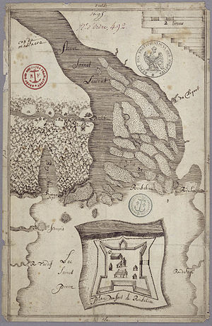
Fort Richelieu
Distance: Approx. 2086 meters
Latitude and longitude: 46.046772,-73.115741
Fort Richelieu is a historic fort in La Vallée-du-Richelieu Regional County Municipality, Quebec, Canada. The fort is designated as a National Historic Site of Canada. Fort Richelieu was part of a series of five forts built along the Richelieu River and is at the mouth of the Richelieu River.

CJSO-FM
Radio station in Sorel-Tracy, Quebec
Distance: Approx. 2520 meters
Latitude and longitude: 46.0425,-73.11666667
CJSO-FM is a French language hot adult contemporary radio station that operates at 101.7 FM in Sorel-Tracy, Quebec, Canada. The station originally began as an AM station in 1945, initially at 1400 kHz, later moving to 1320, until it received CRTC approval to move to the FM band in 1987. CJSO is owned by Radiodiffusion Sorel-Tracy.

Saint-Joseph-de-Sorel
City in Quebec, Canada
Distance: Approx. 3516 meters
Latitude and longitude: 46.03333333,-73.11666667
Saint-Joseph-de-Sorel is a town in the Regional county municipality of Pierre-De Saurel, in Montérégie, Quebec. It is located north of the Tracy section of Sorel-Tracy. Champlain Street marks the town's southern limit from Sorel-Tracy, and the rest of the town is surrounded by water (either Saint Lawrence River or Richelieu River).

Sainte-Anne-de-Sorel
Municipality in Quebec, Canada
Distance: Approx. 4776 meters
Latitude and longitude: 46.05,-73.06666667
Sainte-Anne-de-Sorel (French pronunciation: [sɛ̃t an də sɔʁɛl]) is a municipality in the Pierre-De Saurel Regional County Municipality, in the Montérégie region of Quebec. The community consists of a mainland section along with several islands extending into Lac Saint-Pierre. The population as of the Canada 2011 Census was 2,742, which makes it the largest municipality and the second largest urban division of the RCM. From 2006 throughout 2010 there has been much speculation about Sainte-Anne willing to merge into Sorel-Tracy to become a district (much like the former Saint-Pierre-de-Sorel and Tracy municipalities), however at the present time there has been no future talk about it at both city halls.
La Visitation-de-l'Île-Dupas
Municipality in Quebec, Canada
Distance: Approx. 2863 meters
Latitude and longitude: 46.08333333,-73.15
La Visitation-de-l'Île-Dupas is a municipality in the Lanaudière region of Quebec, Canada, part of the D'Autray Regional County Municipality. Its territory is located on several of the Sorel Islands in the Saint Lawrence River where it flows into Lac Saint-Pierre. The largest of these islands is Dupas Island (Île Dupas), also known as Isle du Pads (or Isle du Pas), Île d'Angoulème, and Île du Richelieu at various times in the past.

Saint-Ignace-de-Loyola
Municipality in Quebec, Canada
Distance: Approx. 699 meters
Latitude and longitude: 46.06666667,-73.13333333
Saint-Ignace-de-Loyola is a municipality in the Lanaudière region of Quebec, Canada, part of the D'Autray Regional County Municipality. Its territory is located on 33 of the Sorel Islands in the Saint Lawrence River where it flows into Lac Saint-Pierre, the largest of which are île Madame, île aux Ours, and La Grande Île.
Les Promenades de Sorel
Distance: Approx. 4799 meters
Latitude and longitude: 46.0239,-73.1036
Les Promenades de Sorel is a 360,000 square feet (33,000 m2) shopping mall located in Sorel-Tracy, Quebec. Its anchor stores are Walmart, Maxi and Bureau en Gros, and it has a total of 51 tenants. Long a Westcliff shopping centre, it is now managed by the Brossard-based Cogir real estate company.

Battle of Sorel
Battle during the Beaver Wars
Distance: Approx. 3516 meters
Latitude and longitude: 46.03333333,-73.11666667
The Battle of Sorel occurred on June 19, 1610, with Samuel de Champlain supported by the Kingdom of France and his allies, the Huron, Algonquin people, and Montagnais that fought against the Mohawk people in New France at present-day Sorel-Tracy, Quebec. The forces of Champlain armed with the arquebus engaged and killed or captured nearly all of the Mohawks. The battle ended major hostilities with the Mohawks for twenty years.
Weather in this IP's area
clear sky
10 Celsius
8 Celsius
10 Celsius
11 Celsius
1031 hPa
64 %
1031 hPa
1030 hPa
10000 meters
3.33 m/s
5.59 m/s
208 degree
07:13:57
18:00:49