157.155.23.131 - IP Lookup: Free IP Address Lookup, Postal Code Lookup, IP Location Lookup, IP ASN, Public IP
Country:
 Australia
Region:
City:
Location:
Time Zone:
Postal Code:
ISP:
ASN:
language:
User-Agent:
Proxy IP:
Blacklist:
IP information under different IP Channel
ip-api
Country
Region
City
ASN
Time Zone
ISP
Blacklist
Proxy
Latitude
Longitude
Postal
Route
db-ip
Country
Region
City
ASN
Time Zone
ISP
Blacklist
Proxy
Latitude
Longitude
Postal
Route
IPinfo
Country
Region
City
ASN
Time Zone
ISP
Blacklist
Proxy
Latitude
Longitude
Postal
Route
IP2Location
157.155.23.131Country
auRegion
victoria
City
toorak
Time Zone
Australia/Melbourne
ISP
Language
User-Agent
Latitude
Longitude
Postal
ipdata
Country
Region
City
ASN
Time Zone
ISP
Blacklist
Proxy
Latitude
Longitude
Postal
Route
Popular places and events near this IP address

Toorak
Suburb of Melbourne, Victoria, Australia
Distance: Approx. 743 meters
Latitude and longitude: -37.841,145.018
Toorak () is a suburb of Melbourne, Victoria, Australia, 5 km (3.1 mi) south-east of Melbourne's Central Business District, located within the City of Stonnington local government area. Toorak recorded a population of 12,817 at the 2021 census. The name Toorak has become synonymous with wealth and privilege, the suburb long having the reputation of being Melbourne's most elite, and ranking among the most prestigious in Australia.

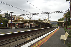
Hawksburn railway station
Railway station in Melbourne, Australia
Distance: Approx. 814 meters
Latitude and longitude: -37.8448,145.0023
Hawksburn railway station is a commuter railway station located in the southern Melbourne suburb of South Yarra in Victoria, Australia. Hawksburn is a below ground unstaffed station, featuring four platforms with an island platform and two side platforms accessible by a pedestrian bridge. The station is listed on the Victorian Heritage Register, and was opened on 7 May 1879.
Toorak railway station
Railway station in Melbourne, Australia
Distance: Approx. 1252 meters
Latitude and longitude: -37.851,145.014
Toorak railway station is a commuter railway station on the northern boundary of Armadale, a suburb of Melbourne, Victoria, Australia. The station is listed on the Victorian Heritage Register, and was opened on 7 May 1879. The station is named after the nearby suburb of Toorak—located north of the station.

Herring Island (Victoria)
Island in Victoria, Australia
Distance: Approx. 975 meters
Latitude and longitude: -37.8332,145.0031
Herring Island is a small 3.2 hectares (7.9 acres) artificial island located in Melbourne's Yarra River at South Yarra, approximately 3 kilometres (1.9 mi) from the city centre. It is the only island in the Yarra River. Herring Island was formed in 1928 by cutting a channel through an old basalt quarry.

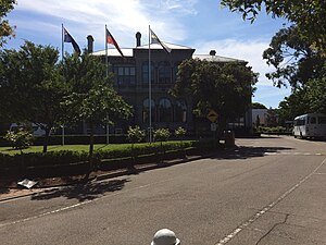
Loreto Mandeville Hall
School in Australia
Distance: Approx. 924 meters
Latitude and longitude: -37.84777778,145.01416667
Loreto Mandeville Hall Toorak is an independent Roman Catholic single-sex primary and secondary day school for girls, located in Toorak, a suburb of Melbourne, Victoria, Australia. It is one of many Loreto schools around the world, established by the Loreto Sisters founded some 400 years ago by Mary Ward. The Loreto Sisters purchased Mandeville Hall in 1924 having previously established schools in Ballarat and Albert Park with encouragement from St Mary MacKillop.
St Catherine's School, Toorak
Independent, day & boarding school in Toorak, Victoria, Australia
Distance: Approx. 1019 meters
Latitude and longitude: -37.83805556,145.02083333
St Catherine's School is an independent and non-denominational Christian day and boarding school for girls, located in Toorak, an inner south-eastern suburb of Melbourne, Victoria, Australia. Established in 1896 as Castlemaine Ladies' College, the school has a non-selective enrolment policy. As of 2025, the school caters for approximately 760 students from pre-school to Year 12, including approximately 40 boarders, on a 2.9 hectare campus.

Toorak House
Mansion in Melbourne, Australia
Distance: Approx. 759 meters
Latitude and longitude: -37.839153,145.018115
Toorak House is a mansion located in Melbourne, Australia built in 1849 by well-known Melbourne merchant James Jackson. It is notable for its use as Melbourne's first Government House and having inspired the name for the suburb of Toorak. Jackson is believed to have borrowed from Woiwurrung language, with words of similar pronunciation, meaning either black crow or reedy swamp.
MacRobertson Bridge
Bridge in Australia
Distance: Approx. 1129 meters
Latitude and longitude: -37.830446,145.012638
The MacRobertson Bridge is a road bridge that carries Grange Road from Toorak on the south bank into Burnley, over the Yarra River and the Monash Freeway in Melbourne, Victoria, Australia. The first river crossing at the site was Twickenham Ferry, which conveyed passengers and was founded by waterman Jesse Barrow in 1880. it was named for the Twickenham Ferry in London.
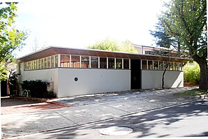
Roy Grounds House
House & apartments in Victoria, Australia
Distance: Approx. 626 meters
Latitude and longitude: -37.835435,145.01318
The Roy Grounds House, at 24 Hill Street, Toorak in Melbourne, Australia, was designed by Sir Roy Grounds as his own home for his wife Betty and himself. It is celebrated as one of the most outstanding works of modernist domestic architecture of the mid 20th century in Victoria, a time of great experimentation, and one of the most notable designs by Roy Grounds, one of the most well known and influential modern architects in Victoria.
Electoral district of Toorak
Former state electoral district of Victoria, Australia
Distance: Approx. 48 meters
Latitude and longitude: -37.84,145.01
The electoral district of Toorak was an electorate of the Victorian Legislative Assembly in the British colony and later Australian state of Victoria.
Toorak Art Gallery
Australian art gallery in Melbourne closed 1975
Distance: Approx. 1179 meters
Latitude and longitude: -37.839511,144.996228
Toorak Art Gallery was an art gallery 277 Toorak Road, South Yarra, Melbourne, Victoria, which specialised in contemporary figurative and abstract Australian art. It was in operation from 1964 to 1975.
Gallery A
Art gallery in Melbourne, Victoria, Australia
Distance: Approx. 1180 meters
Latitude and longitude: -37.839488,144.996215
Gallery A was a mid-century Australian gallery that exhibited contemporary Australian art. It was established in 1959 at 60 Flinders Lane, Melbourne, and then relocated to 275 Toorak Road., South Yarra. A second Gallery A venue was opened and run concurrently at 21 Gipps Street, Paddington in Sydney from 1964, and a third in Canberra (1964, closed 1970).
Weather in this IP's area
broken clouds
25 Celsius
25 Celsius
24 Celsius
27 Celsius
1004 hPa
56 %
1004 hPa
1001 hPa
10000 meters
7.15 m/s
14.67 m/s
13 degree
57 %