Country:
Region:
City:
Latitude and Longitude:
Time Zone:
Postal Code:
IP information under different IP Channel
ip-api
Country
Region
City
ASN
Time Zone
ISP
Blacklist
Proxy
Latitude
Longitude
Postal
Route
Luminati
Country
Region
ca
City
sanfrancisco
ASN
Time Zone
America/Los_Angeles
ISP
AS-SONICTELECOM
Latitude
Longitude
Postal
IPinfo
Country
Region
City
ASN
Time Zone
ISP
Blacklist
Proxy
Latitude
Longitude
Postal
Route
db-ip
Country
Region
City
ASN
Time Zone
ISP
Blacklist
Proxy
Latitude
Longitude
Postal
Route
ipdata
Country
Region
City
ASN
Time Zone
ISP
Blacklist
Proxy
Latitude
Longitude
Postal
Route
Popular places and events near this IP address

Excelsior District, San Francisco
Neighborhood of San Francisco
Distance: Approx. 763 meters
Latitude and longitude: 37.72058,-122.43276
The Excelsior District is a neighborhood in San Francisco, California.

Crocker-Amazon, San Francisco
Neighborhood of San Francisco
Distance: Approx. 828 meters
Latitude and longitude: 37.71282,-122.43945
Crocker-Amazon is a neighborhood in San Francisco that borders the Excelsior District. Crocker-Amazon covers the area south of Mission Street and Geneva Avenue, extending toward suburban Daly City. The neighborhood is adjacent to Crocker-Amazon Park, named after the Charles Crocker land holdings that once made up the area, and Amazon Avenue in the Excelsior.
Lick-Wilmerding High School
Private school
Distance: Approx. 700 meters
Latitude and longitude: 37.72222222,-122.44888889
Lick-Wilmerding High School is a private college-preparatory high school located in San Francisco, California, United States.

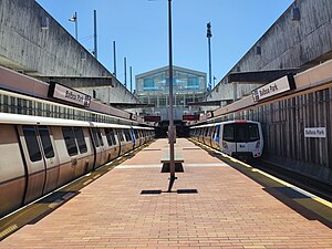
Balboa Park station
Transit station in San Francisco, California, US
Distance: Approx. 565 meters
Latitude and longitude: 37.72166667,-122.4475
Balboa Park station is a Bay Area Rapid Transit (BART) station and Muni Metro complex in the Mission Terrace neighborhood of San Francisco, California, located near the eponymous Balboa Park. It is an intermodal hub served by four BART routes, three Muni Metro lines, and a number of Muni bus routes. The station complex also includes two rail yards, Cameron Beach Yard and Green Light Rail Center, where Muni maintains Muni Metro trains and heritage streetcars.
Leadership High School
Distance: Approx. 344 meters
Latitude and longitude: 37.7215,-122.44488889
Leadership High School is a public charter high school located in San Francisco. Founded in 1997, Leadership or "LHS" was California's first start-up charter high school. The school provides a college-preparatory curriculum and focuses on leadership development and social justice.

Balboa High School (California)
School in San Francisco, San Francisco, California, United States
Distance: Approx. 194 meters
Latitude and longitude: 37.72182778,-122.44107222
Balboa High School, colloquially known as Bal, is an American public high school located near the Excelsior District in the Mission Terrace neighborhood of San Francisco, California, United States. Balboa serves grades nine through twelve as part of the San Francisco Unified School District (SFUSD). Balboa is a comprehensive school located in an urban working class district.
School of the Epiphany
Private school in San Francisco, California, United States
Distance: Approx. 744 meters
Latitude and longitude: 37.71591944,-122.43480833
School of the Epiphany, colloquially called Epiphany or Epiphany School, is a Catholic school in San Francisco, California. The school opened in 1938 and is named for the Feast of the Epiphany.

Boxer Stadium
American Sport Stadium
Distance: Approx. 693 meters
Latitude and longitude: 37.725788,-122.444593
Boxer Stadium (also known as Matthew J. Boxer Stadium) is a soccer stadium in San Francisco, California. Located in Balboa Park, the stadium has a capacity of 3,500. It is owned and operated by the San Francisco Recreation & Parks Department and is the only public soccer-specific stadium in San Francisco.
San Jose and Ocean station
Distance: Approx. 435 meters
Latitude and longitude: 37.72293,-122.44481
San Jose and Ocean station is a light rail stop on the Muni Metro J Church line, located in the Mission Terrace neighborhood of San Francisco, California adjacent to the Balboa Park neighborhood and the Balboa Park station complex. The station has two side platforms in the middle of San Jose Avenue (traffic islands) located before the intersection in each direction. The station is not accessible.
San Jose and Santa Ynez station
Distance: Approx. 638 meters
Latitude and longitude: 37.72578,-122.4424
San Jose and Santa Ynez station is a light rail stop on the Muni Metro J Church line, located in the Mission Terrace neighborhood of San Francisco, California adjacent to Balboa Park. The station has two short side platforms in the middle of San Jose Avenue (traffic islands) located before the intersection in each direction. The station is not accessible.

San Jose and Mount Vernon station
Light rail stop in San Francisco, California, US
Distance: Approx. 670 meters
Latitude and longitude: 37.71837,-122.44869
San Jose and Mount Vernon station was a light rail stop on the Muni Metro M Ocean View line, located in the Ingleside neighborhood of San Francisco, California. The station had two side platforms (traffic islands) in the middle of San Jose Avenue; the inbound platform is located on a bridge over Interstate 280. The platforms were not accessible.
Church of the Epiphany (San Francisco)
Church in California, USA
Distance: Approx. 775 meters
Latitude and longitude: 37.71583333,-122.43444444
The Church of the Epiphany is a Catholic church under the Archdiocese of San Francisco. It is located in the Excelsior District near Crocker Amazon Park.
Weather in this IP's area
scattered clouds
18 Celsius
17 Celsius
16 Celsius
20 Celsius
1015 hPa
42 %
1015 hPa
1009 hPa
10000 meters
3.6 m/s
300 degree
40 %
06:44:10
17:03:14

