Country:
 USA
USARegion:
City:
Latitude and Longitude:
Time Zone:
Postal Code:
IP information under different IP Channel
ip-api
Country
Region
City
ASN
Time Zone
ISP
Blacklist
Proxy
Latitude
Longitude
Postal
Route
IPinfo
Country
Region
City
ASN
Time Zone
ISP
Blacklist
Proxy
Latitude
Longitude
Postal
Route
MaxMind
Country
Region
City
ASN
Time Zone
ISP
Blacklist
Proxy
Latitude
Longitude
Postal
Route
Luminati
Country
USRegion
ca
City
oakland
ASN
Time Zone
America/Los_Angeles
ISP
AS-SONICTELECOM
Latitude
Longitude
Postal
db-ip
Country
Region
City
ASN
Time Zone
ISP
Blacklist
Proxy
Latitude
Longitude
Postal
Route
ipdata
Country
Region
City
ASN
Time Zone
ISP
Blacklist
Proxy
Latitude
Longitude
Postal
Route
Popular places and events near this IP address
Oakland firestorm of 1991
Suburban wildland-urban interface conflagration in California
Distance: Approx. 1386 meters
Latitude and longitude: 37.861124,-122.221892
The Oakland firestorm of 1991 was a large suburban wildland–urban interface conflagration that occurred on the hillsides of northern Oakland, California, and southeastern Berkeley over the weekend of October 19–20, 1991, before being brought under full control on October 23. The official name of this incident by Cal Fire is the Tunnel Fire. It is also commonly referred to as the Oakland Hills firestorm or the East Bay Hills fire.
KPFA
Public, listener-funded radio station in Berkeley, California
Distance: Approx. 1815 meters
Latitude and longitude: 37.865,-122.221
KPFA (94.1 FM) is a public, listener-funded talk radio and music radio station located in Berkeley, California, broadcasting to the San Francisco Bay Area. KPFA airs public news, public affairs, talk, and music programming. The station signed on the air April 15, 1949, as the first Pacifica Radio station and remains the flagship station of the Pacifica Radio Network.

Claremont Canyon Regional Preserve
Distance: Approx. 1887 meters
Latitude and longitude: 37.865203,-122.225801
Claremont Canyon Regional Preserve is a small regional park mainly located in the city of Oakland, California, and administered by the East Bay Regional Park District. The park is named for the canyon in which it is situated, Claremont Canyon, out of which Claremont Creek flows on its way to its confluence with Temescal Creek. Previously the canyon was named Harwood's Canyon, and then later as Telegraph Canyon.
The College Preparatory School
Private college preparatory school in Oakland, California, US
Distance: Approx. 1676 meters
Latitude and longitude: 37.84844722,-122.23996944
REDIRECT [[]] The College Preparatory School (CPS or College Prep) is a four-year private non-residential high school in Oakland, California most known for its placement rates into elite colleges and its speech and debate program. The school's motto is Mens Conscia Recti, a Latin phrase adapted from Virgil's Aeneid that means "a mind aware of what is right".
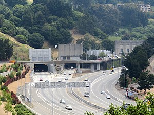
Caldecott Tunnel
Highway tunnel between Oakland and Orinda, California
Distance: Approx. 777 meters
Latitude and longitude: 37.8548,-122.2166
The Caldecott Tunnel is a four-bore highway tunnel through the Berkeley Hills between Oakland and Orinda, California. Its four bores carry California State Route 24. Named after Thomas E. Caldecott, former mayor of Berkeley, it opened in 1937 as a two-bore tunnel.
Caldecott Tunnel fire
1982 wildfire in California
Distance: Approx. 1247 meters
Latitude and longitude: 37.858,-122.213
The Caldecott Tunnel fire killed seven people in the third (then-northernmost) bore of the Caldecott Tunnel, on State Route 24 between Oakland and Orinda in the U.S. state of California, just after midnight on 7 April 1982. It is one of the few major tunnel fires involving a cargo normally considered to be highly flammable, namely gasoline. At the time of the fire, the Caldecott tunnel complex consisted of three bores side-by-side, each 0.7 mi long (1.1 km).

Montclair, Oakland, California
Neighborhood of Oakland in Alameda, California, United States
Distance: Approx. 2104 meters
Latitude and longitude: 37.832222,-122.209167
Montclair (also known as the Montclair District or Montclair Village) is a hillside neighborhood in Oakland, California, United States. Montclair is located along the western slope of the Oakland Hills from a valley formed by the Hayward Fault to the upper ridge of the hills. Although there is no formal definition of the neighborhood, the general boundaries are Highway 24 to the north, Joaquin Miller Road to the south, the city of Piedmont to the west and the Contra Costa County border to the east.

Mountain View Cemetery (Oakland, California)
Historic rural cemetery in Alameda County
Distance: Approx. 2055 meters
Latitude and longitude: 37.83527778,-122.23694444
The Mountain View Cemetery is a 226-acre (91 ha) rural cemetery in Oakland, California, United States. It was established in 1863 by a group of East Bay pioneers under the California Rural Cemetery Act of 1859. The association they formed still operates the cemetery today.
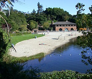
Lake Temescal
Lake in California, USA
Distance: Approx. 928 meters
Latitude and longitude: 37.84777778,-122.23138889
Lake Temescal is a small reservoir in the Oakland hills, in northeastern Oakland, California. It is the centerpiece of Temescal Regional Recreation Area, also known as Temescal Regional Park (and originally, Lake Temescal Regional Park). It is a part of the East Bay Regional Park District.
Temescal Regional Recreational Area
Regional park in Oakland, California, U.S.
Distance: Approx. 928 meters
Latitude and longitude: 37.84777778,-122.23138889
Temescal Regional Recreation Area (TRRA), formerly Lake Temescal Regional Park, is a regional park in the Berkeley Hills, in northeastern Oakland, California. The TRRA encompasses 48 acres (19 ha), abutting SR 24, SR13, and the interchange connecting the two highways, southwest of the Caldecott Tunnel.The park is part of the East Bay Regional Park District (EBRPD).

Holy Names High School (Oakland, California)
Private, all-female school in Oakland, , California, United States
Distance: Approx. 1376 meters
Latitude and longitude: 37.83926,-122.231
Holy Names High School is a private Catholic girls college preparatory high school located in the Oakland Hills in Oakland, California. It is located in the Roman Catholic Diocese of Oakland. The campus is also home to Aurora Elementary School and the former home to the convent for the Sisters of the Holy Names of Jesus and Mary.

Robert Sibley Volcanic Regional Preserve
Nature preserve in the San Francisco Bay Area
Distance: Approx. 1699 meters
Latitude and longitude: 37.85495,-122.20326
Robert Sibley Volcanic Regional Preserve is located in the Oakland Hills of the East Bay region of the San Francisco Bay Area, California. The park is part of the East Bay Regional Parks District (EBRPD), covers 928 acres (3.76 km2), and lies east of Oakland, partly in Alameda County and partly in Contra Costa County. It can be entered from Oakland via Skyline Boulevard, or from Contra Costa County via Old Tunnel Road.
Weather in this IP's area
few clouds
19 Celsius
19 Celsius
16 Celsius
25 Celsius
1011 hPa
69 %
1011 hPa
985 hPa
10000 meters
5.14 m/s
310 degree
20 %
06:54:37
19:10:23