Country:
Region:
City:
Latitude and Longitude:
Time Zone:
Postal Code:
IP information under different IP Channel
ip-api
Country
Region
City
ASN
Time Zone
ISP
Blacklist
Proxy
Latitude
Longitude
Postal
Route
Luminati
Country
Region
02
City
aomori
ASN
Time Zone
Asia/Tokyo
ISP
Aomori Cable TV Co., Ltd.
Latitude
Longitude
Postal
IPinfo
Country
Region
City
ASN
Time Zone
ISP
Blacklist
Proxy
Latitude
Longitude
Postal
Route
db-ip
Country
Region
City
ASN
Time Zone
ISP
Blacklist
Proxy
Latitude
Longitude
Postal
Route
ipdata
Country
Region
City
ASN
Time Zone
ISP
Blacklist
Proxy
Latitude
Longitude
Postal
Route
Popular places and events near this IP address

Aomori
Core city in Tōhoku, Japan
Distance: Approx. 2265 meters
Latitude and longitude: 40.82277778,140.74694444
Aomori (Japanese: 青森, Hepburn: Aomori, IPA: [aoꜜmoɾi]; lit. "Blue Forest"), officially Aomori City (青森市, Aomori-shi), is the capital city of Aomori Prefecture, in the Tōhoku region of Japan. As of 1 August 2023, the city had an estimated population of 264,945 in 136,781 households, and a population density of 321 people per square kilometer spread over the city's total area of 824.61 km2 (318.38 sq mi).

Aomori Prefecture
Prefecture of Japan
Distance: Approx. 1686 meters
Latitude and longitude: 40.82472222,140.74055556
Aomori Prefecture (青森県, Aomori-ken) ([a̠o̞mo̞ɾʲikẽ̞ɴ]) is a prefecture of Japan in the Tōhoku region. The prefecture's capital, largest city, and namesake is the city of Aomori. Aomori is the northernmost prefecture on Japan's main island, Honshu, and is bordered by the Pacific Ocean to the east, Iwate Prefecture to the southeast, Akita Prefecture to the southwest, the Sea of Japan to the west, and Hokkaido across the Tsugaru Strait to the north.

Aomori Station
Railway station in Aomori, Aomori Prefecture, Japan
Distance: Approx. 1093 meters
Latitude and longitude: 40.82885278,140.73469167
Aomori Station (青森駅, Aomori-eki) is a railway station in the city of Aomori in Aomori Prefecture, Japan. The station has been operating since September 1891, though the most recent station building, which consists of three island platforms connected to the station building by a footbridge, was completed in March 2021. Since 1987 the station has been used by the East Japan Railway Company (JR East) which operates various services to destinations throughout the Tōhoku region.

Shin-Aomori Station
Railway station in Aomori, Aomori Prefecture, Japan
Distance: Approx. 2402 meters
Latitude and longitude: 40.8275,140.69347222
Shin-Aomori Station (新青森駅, Shin-Aomori-eki) is a railway station in the city of Aomori, Aomori Prefecture, Japan, operated by the East Japan Railway Company (JR East) and the Hokkaido Railway Company (JR Hokkaido).

Aomori Nebuta Matsuri
Japanese summer festival
Distance: Approx. 2318 meters
Latitude and longitude: 40.82234194,140.74739
The Aomori Nebuta Matsuri (青森ねぶた祭, "Aomori Nebuta Festival" or simply "Aomori Nebuta") is a Japanese summer festival that takes place in Aomori, Aomori Prefecture, Japan in early August. The festival attracts the most tourists of any of the country's nebuta festivals, and is counted among the three largest festivals in the Tōhoku region. It was designated an Important Intangible Folk Cultural Property in 1980, and as one of the 100 Soundscapes of Japan by the Ministry of the Environment in 1996.

Aomori Bay Bridge
Bridge in Aomori City, Aomori Prefecture
Distance: Approx. 1253 meters
Latitude and longitude: 40.83027778,140.73666667
The Aomori Bay Bridge (青森ベイブリッジ, Aomori Bei Burijji) is a cable-stayed bridge in Aomori, Aomori Prefecture, Japan. It was constructed in order to alleviate cargo ship traffic. It is a very notable part of Aomori's skyline.

Aomori Prefecture Tourist Center
Skyscraper in Aomori, Aomori Prefecture, Japan
Distance: Approx. 1627 meters
Latitude and longitude: 40.82972222,140.74111111
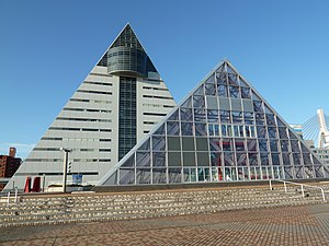
The Aomori Prefecture Tourist Center (ASPM) (青森県観光物産館アスパム, Aomori-ken Kankō Bussankan (Asupamu)) is a skyscraper located in Aomori, Aomori Prefecture, Japan. Construction of the 76-meter, 15-story skyscraper was finished in 1986.

Aomori Prefectural Museum
Museum in Aomori Prefecture, Japan
Distance: Approx. 2286 meters
Latitude and longitude: 40.8273,140.7487
The Aomori Prefectural Museum (青森県立郷土館, Aomori Kenritsu Kyōdokan) is a museum located in Aomori, Aomori Prefecture, Japan. The museum has a collection of artifacts from the Jōmon Period, as well as exhibits detailing Aomori's culture and history. The museum opened in 1973.
Aomori Museum of History
Building in Aomori Prefecture, Japan
Distance: Approx. 857 meters
Latitude and longitude: 40.837244,140.725249
Aomori Museum of History (あおもり北のまほろば歴史館, Aomori Kita no Mahoroba Rekishi-kan) opened in Aomori, Aomori Prefecture, Japan, in 2015. Formerly the Michinoku Traditional Wooden Boat Museum (みちのく北方漁船博物館, Michinoku Hoppyō Gyosen Hakubutsukan), the collection introduces the history and folk culture of Aomori City and includes the Important Tangible Folk Cultural Property Collection of mudamahagi fishing boats from Tsugaru Strait and surrounding areas.

Nebuta Museum Wa Rasse
Museum in Aomori, Japan
Distance: Approx. 1192 meters
Latitude and longitude: 40.82955556,140.73594444
The Nebuta Museum Wa Rasse (ねぶたの家 ワ・ラッセ, Nebuta no ie Wa-Rasse) is a city-owned museum near Aomori Station in the city of Aomori in northern Japan. It displays a revolving exhibit of four Nebuta floats from the most recent Aomori Nebuta Matsuri summer festival, alongside media related to the festival. The museum opened in January 2011.

Aomori metropolitan area
Metropolitan area in Aomori, Japan ----
Distance: Approx. 1546 meters
Latitude and longitude: 40.81666667,140.71666667
The Aomori metropolitan area (青森都市圏, Aomori toshi-ken), also known as the Tōsei area (東青地域, Tōsei chiiki) is a metropolitan region in the Japanese prefecture of Aomori that includes the city of Aomori and its surrounding satellites, Hiranai, Imabetsu, Sotogahama, and Yomogita. The metropolitan area is defined as the Aomori Urban Employment Area by the Statistics Bureau of Japan (SBJ) and the Center for Spatial Information Service of the University of Tokyo.

Aoimori Park
Urban park in Aomori, Japan
Distance: Approx. 1817 meters
Latitude and longitude: 40.82416667,140.74194444
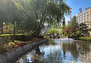
Aoimori Park (青い森公園, Aoimori kōen) is a 1.8-hectare (4.4-acre) urban park in the central district of Aomori Prefecture's capital city, Aomori in northern Japan. Acting as an urban green space in the city's dense administrative district, it features various themed landscapes. It has been maintained by the prefectural government of Aomori since its opening in 1985.
Weather in this IP's area
broken clouds
5 Celsius
4 Celsius
4 Celsius
6 Celsius
1020 hPa
84 %
1020 hPa
1020 hPa
10000 meters
1.34 m/s
1.79 m/s
225 degree
74 %
06:12:11
16:29:12
