157.100.69.153 - IP Lookup: Free IP Address Lookup, Postal Code Lookup, IP Location Lookup, IP ASN, Public IP
Country:
Region:
City:
Location:
Time Zone:
Postal Code:
IP information under different IP Channel
ip-api
Country
Region
City
ASN
Time Zone
ISP
Blacklist
Proxy
Latitude
Longitude
Postal
Route
Luminati
Country
Region
g
City
guayaquil
ASN
Time Zone
America/Guayaquil
ISP
UFINET PANAMA S.A.
Latitude
Longitude
Postal
IPinfo
Country
Region
City
ASN
Time Zone
ISP
Blacklist
Proxy
Latitude
Longitude
Postal
Route
IP2Location
157.100.69.153Country
Region
manabi
City
portoviejo
Time Zone
America/Guayaquil
ISP
Language
User-Agent
Latitude
Longitude
Postal
db-ip
Country
Region
City
ASN
Time Zone
ISP
Blacklist
Proxy
Latitude
Longitude
Postal
Route
ipdata
Country
Region
City
ASN
Time Zone
ISP
Blacklist
Proxy
Latitude
Longitude
Postal
Route
Popular places and events near this IP address

Manabí Province
Province of Ecuador
Distance: Approx. 256 meters
Latitude and longitude: -1.05222,-80.4506
Manabí (Spanish pronunciation: [manaˈβi]) is a province in the Republic of Ecuador. Its capital is Portoviejo. The province is named after the Manabí people.

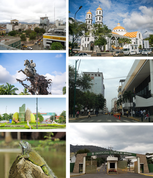
Portoviejo
City in Manabí, Ecuador
Distance: Approx. 899 meters
Latitude and longitude: -1.05611111,-80.45527778
Portoviejo (Spanish pronunciation: [poɾtoˈβjexo]), also known as San Gregorio de Portoviejo, is a city in Ecuador, and the capital of the Province of Manabí 30 km (19 mi) from the Pacific coast. It is still known as the city of the "Royal Tamarind Trees" due to former Tamarind plantations in the area. It serves as the main political and economical centre of the Portoviejo River valley, which also includes the cantons of Santa Ana and Rocafuerte, where about 110 km2 (42 square miles) are cultivated every year.

Estadio Reales Tamarindos
Distance: Approx. 471 meters
Latitude and longitude: -1.04848611,-80.45395
Estadio Reales Tamarindos is a multi-use stadium in Portoviejo, Ecuador. It is currently used mostly for football matches and is the home stadium of Liga Deportiva Universitaria de Portoviejo. The stadium has a capacity of 21,000 spectators and opened in 1970.

Roman Catholic Archdiocese of Portoviejo
Roman Catholic archdiocese in Ecuador
Distance: Approx. 498 meters
Latitude and longitude: -1.0522,-80.4539
The Roman Catholic Metropolitan Archdiocese of Portoviejo (Latin: Archidioecesis Portus Veteris) is an archdiocese located in the city of Portoviejo in Ecuador.
Picoazá
Urban parish in Manabí Province, Ecuador
Distance: Approx. 5866 meters
Latitude and longitude: -1.03333333,-80.5
Picoazá is an urban parish in Portoviejo Canton, Manabí Province, Ecuador. It is situated on the western side of the city of Portoviejo and has a population of nearly 19,000.

University San Gregorio de Portoviejo
Distance: Approx. 2736 meters
Latitude and longitude: -1.06388889,-80.47027778
The University San Gregorio de Portoviejo also known as USGP, is an autonomous institution with social and public purposes and can provide education, conduct research with scientific freedom - administrative, and participate in national development plans, grant, recognize and validate academic degrees and professional qualifications, and generally perform the activities to achieve its goals.
Christ the King School, Portoviejo
Private primary and secondary school in Portoviejo, Ecuador
Distance: Approx. 594 meters
Latitude and longitude: -1.05416667,-80.44666667
Christ the King School (Spanish: Unidad Educativa Cristo Rey) is a private Catholic primary and secondary school, located in Portoviejo, Ecuador. Established in 1930 as a seminary run by the Society of Jesus, the school grew to be pre-primary through high school, and serves the needier segment of society.

Technical University of Manabi
University in Portoviejo, Ecuador
Distance: Approx. 918 meters
Latitude and longitude: -1.04416667,-80.45583333
The Technical University of Manabí (UTM), is a public institution of higher education located in the city of Portoviejo, Manabí, Ecuador. It was founded on October 29, 1952, in the presidential government of Dr. José María Velasco Ibarra.
Weather in this IP's area
overcast clouds
28 Celsius
29 Celsius
28 Celsius
28 Celsius
1012 hPa
62 %
1012 hPa
1004 hPa
10000 meters
0.71 m/s
1.21 m/s
306 degree
94 %