Country:
 Indonesia
Region:
City:
Latitude and Longitude:
Time Zone:
Postal Code:
IP information under different IP Channel
ip-api
Country
Region
City
ASN
Time Zone
ISP
Blacklist
Proxy
Latitude
Longitude
Postal
Route
IPinfo
Country
Region
City
ASN
Time Zone
ISP
Blacklist
Proxy
Latitude
Longitude
Postal
Route
MaxMind
Country
Region
City
ASN
Time Zone
ISP
Blacklist
Proxy
Latitude
Longitude
Postal
Route
Luminati
Country
IDASN
Time Zone
Asia/Jakarta
ISP
PT Parsaoran Global Datatrans
Latitude
Longitude
Postal
db-ip
Country
Region
City
ASN
Time Zone
ISP
Blacklist
Proxy
Latitude
Longitude
Postal
Route
ipdata
Country
Region
City
ASN
Time Zone
ISP
Blacklist
Proxy
Latitude
Longitude
Postal
Route
Popular places and events near this IP address

Palembang
City and capital of South Sumatra, Indonesia
Distance: Approx. 407 meters
Latitude and longitude: -2.98611111,104.75555556
Palembang (Indonesian pronunciation: [paˈlɛmbaŋ], Palembang: Pelémbang, Jawi: ڤليمبڠ) is the capital city of the Indonesian province of South Sumatra. The city proper covers 352.51 square kilometres (136.10 square miles) on both banks of the Musi River in the eastern lowlands of southern Sumatra. It had a population of 1,668,848 at the 2020 Census; the official estimate as at mid 2023 was 1,772,492 (comprising 887,101 males and 885,391 females).

Roman Catholic Archdiocese of Palembang
Roman Catholic archdiocese in South Sumatra, Indonesia
Distance: Approx. 1389 meters
Latitude and longitude: -2.9889375,104.7471875
The Roman Catholic Archdiocese of Palembang (Latin: Palembangen(sis)) is an archdiocese located in the city of Palembang in South Sumatra in Indonesia.

Garuda Indonesian Airways Flight 150
1975 aviation accident
Distance: Approx. 500 meters
Latitude and longitude: -2.9888243,104.7568507
Garuda Indonesian Airways Flight 150 was a scheduled Indonesian domestic passenger flight from Kemayoran Airport, Jakarta to Sultan Mahmud Badaruddin II Airport, Palembang. On 24 September 1975, Flight 150 crashed on approach due to poor weather and fog just 2.5 miles (2.2 nmi; 4.0 km) from the town of Palembang. The accident killed 25 out of the 61 passengers and crew on board, and one person on the ground.

Ampera Bridge
Vertical-lift bridge in Palembang, Indonesia
Distance: Approx. 909 meters
Latitude and longitude: -2.9917,104.7635
Ampera Bridge (Indonesian: Jembatan Ampera, for Amanat Penderitaan Rakyat [Mandate of People's Suffering], a now-rarely used colloquial name for the preamble of the Constitution of Indonesia), formerly Bung Karno Bridge (Indonesian: Jembatan Bung Karno, after President Sukarno) between its opening and the 1966 De-Sukarnoization campaign, is a vertical-lift bridge in the city of Palembang, South Sumatra, Indonesia. It connects Seberang Ulu and Seberang Ilir, two regions of Palembang. It can no longer be opened to allow ships to pass.
Palembang Sport and Convention Center
Distance: Approx. 1693 meters
Latitude and longitude: -2.978235,104.745299
Palembang Sport and Convention Center or simply PSCC (formerly known as the Sport Hall) is a multi-purpose indoor arena located in the downtown of Palembang, South Sumatra, Indonesia, in one of the city's well-known business area, Centre Point. Established in 2011 for the 2011 Southeast Asian Games, it is praised for its modern and chic design, and its volleyball field is the best in the nation.
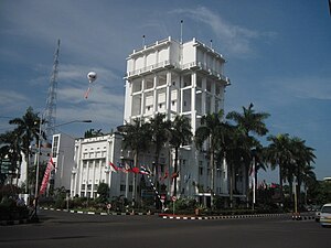
Palembang Mayoral Office
Historic building
Distance: Approx. 728 meters
Latitude and longitude: -2.991,104.7567
The Palembang Mayoral Office, also known as Kantor Ledeng, is an office building in Palembang, South Sumatra, Indonesia, which is used as the seat of the municipal government of the city. It was built as a water tower with an office for the colonial government on the lower floors by the Dutch, and was later also used by Japanese authorities during the Japanese occupation of the city.

Sultan Mahmud Badaruddin II Museum
Museum of the Palembang Sultanate.
Distance: Approx. 647 meters
Latitude and longitude: -2.990313,104.761067
Sultan Mahmud Badaruddin II Museum is a municipal museum in Palembang, Indonesia. The museum is established inside a 19th-century building former of the office of the colonial resident of South Sumatra. The building also houses the tourist department of Palembang.

Kuto Besak
Distance: Approx. 726 meters
Latitude and longitude: -2.9914,104.7592
Kuto Besak, also Benteng Kuto Besak (Indonesian "Kuto Besak Fortress") is an 18th-century kraton (Indonesian forted palace) in Palembang, South Sumatra. Kuto Besak was the center of the Sultanate of Palembang before its abolition by the Dutch colonial government. The fort was constructed in 1780 and took seventeen years to complete.

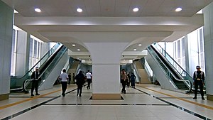
Ampera LRT station
Distance: Approx. 566 meters
Latitude and longitude: -2.988946,104.762056
Ampera Station is a station of the Palembang LRT Line 1, located in Ilir Timur I, Palembang. The station is close to the Ampera Bridge and Kuto Besak Fortress. The station became one of six stations that opened at the Palembang LRT launch on 1 August 2018.
Bumi Sriwijaya LRT station
Distance: Approx. 1755 meters
Latitude and longitude: -2.977145,104.745244
Bumi Sriwijaya Station (formerly Palembang Icon Station) is a station of the Palembang LRT Line 1, located in Ilir Barat I, Palembang. The station is close to the Bumi Sriwijaya Stadium and the Palembang Icon Mall. The station became one of six stations that opened at the Palembang LRT launch on 1 August 2018.

Cinde LRT station
Light rail station in Palembang, Indonesia
Distance: Approx. 559 meters
Latitude and longitude: -2.980701,104.756216
Cinde Station is a station of the Palembang LRT Line 1. located in Ilir Timur I, Palembang. The station is close to the Cinde Market and the Entrepreneur Monument.

Dishub LRT station
Distance: Approx. 1326 meters
Latitude and longitude: -2.978489,104.748939
Dishub Station is a station of the Palembang LRT Line 1. The station is located between Bumi Sriwijaya station and Cinde station. Nearby the station is South Sumatra Province's Office of Transportation (Dinas Perhubungan Provinsi Sumatera Selatan, abbreviated as Dishub), hence its name.
Weather in this IP's area
scattered clouds
33 Celsius
38 Celsius
33 Celsius
33 Celsius
1007 hPa
55 %
1007 hPa
1006 hPa
10000 meters
1.03 m/s
200 degree
40 %
05:40:01
17:51:09