Country:
 Indonesia
Region:
City:
Latitude and Longitude:
Time Zone:
Postal Code:
IP information under different IP Channel
ip-api
Country
Region
City
ASN
Time Zone
ISP
Blacklist
Proxy
Latitude
Longitude
Postal
Route
IPinfo
Country
Region
City
ASN
Time Zone
ISP
Blacklist
Proxy
Latitude
Longitude
Postal
Route
MaxMind
Country
Region
City
ASN
Time Zone
ISP
Blacklist
Proxy
Latitude
Longitude
Postal
Route
Luminati
Country
IDASN
Time Zone
Asia/Jakarta
ISP
PT Parsaoran Global Datatrans
Latitude
Longitude
Postal
db-ip
Country
Region
City
ASN
Time Zone
ISP
Blacklist
Proxy
Latitude
Longitude
Postal
Route
ipdata
Country
Region
City
ASN
Time Zone
ISP
Blacklist
Proxy
Latitude
Longitude
Postal
Route
Popular places and events near this IP address
Universitas Siswa Bangsa Internasional
University in Indonesia
Distance: Approx. 1391 meters
Latitude and longitude: -6.247814,106.844884
Universitas Siswa Bangsa Internasional (also known by the acronym USBI), or Sampoerna University, is an international university located in Jakarta, Indonesia. It is the first Indonesian university to offer an accredited U.S. degree entirely within Indonesia.

Gama Tower
Skyscraper in Jakarta, Indonesia
Distance: Approx. 1544 meters
Latitude and longitude: -6.224153,106.833731
Gama Tower (formerly known as Cemindo Tower) is a skyscraper located at Jalan H.R. Rasuna Said, South Jakarta, Indonesia. It was also known as Rasuna Tower and Cemindo Tower during construction period, but finally named as Gama Tower. As of 2022, it is the 3rd tallest building in Jakarta, as well as Indonesia.

Embassy of the United Kingdom, Jakarta
Diplomatic mission
Distance: Approx. 832 meters
Latitude and longitude: -6.2307739,106.8344457
The Embassy of the United Kingdom in Jakarta is the chief diplomatic mission of the United Kingdom in Indonesia.
World Capital Tower
Office in Jakarta, Indonesia
Distance: Approx. 1532 meters
Latitude and longitude: -6.229326,106.826759
World Capital Tower is a skyscraper at Mega Kuningan, South Jakarta, Indonesia. The skyscraper has total floor area of 70,000 sq.meters with retail & entertainment space. The tower, which is 270 meter-tall, has 54 floors.
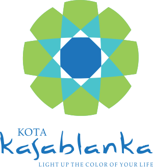
Kota Kasablanka
Shopping mall in Jakarta, Indonesia
Distance: Approx. 1620 meters
Latitude and longitude: -6.223576,106.842685
Kota Kasablanka is a mixed-development covering an area of 11.5 hectares (28 acres) at Tebet in Jakarta, Indonesia, which consists of office tower, serviced office suites, shopping center, convention hall and condominium towers. This super-block is developed by PT Pakuwon Jati Tbk (PWON). CasaGrande Residence is the apartment block which has four towers, each has 36 floors namely Mirage, Avalon, Montreal and Montana.

Dirgantara Monument
Monument in Jakarta, Indonesia
Distance: Approx. 879 meters
Latitude and longitude: -6.243085,106.843472
Dirgantara Monument (Indonesian: Monumen Patung Dirgantara), also known as Gatot Kaca Monument after the Javanese wayang figure, is a monument located in Jakarta, Indonesia. It is also known as Tugu Pancoran, after tugu a word for statue and pedestal, and the South Jakarta subdistrict of Pancoran, where it is located. The monument was commissioned by President Sukarno in 1964 as a tribute to the Indonesian Air Force and early Indonesian aviators who flew against the Dutch to achieve independence.

Baru Barat River
River in Jakarta, Indonesia
Distance: Approx. 687 meters
Latitude and longitude: -6.2347,106.8436
The Baru Barat River (Indonesian: Kali Baru Barat, lit. 'Western New River') is a man-made canal flowing from the Cisadane River in Bogor Regency to Jakarta, Indonesia. It was one of two canals built in the 18th century under the order of the Governor-General Gustaaf Willem van Imhoff, the other being the Baru Timur River (Indonesian: Kali Baru Timur, lit. 'Eastern New River'). Both canals were originally built to transport agricultural harvests from Bogor to Batavia (now Jakarta).

Embassy of Australia, Jakarta
Diplomatic mission
Distance: Approx. 726 meters
Latitude and longitude: -6.23208333,106.83413889
The Embassy of Australia in Jakarta (Indonesian: Kedutaan Besar Australia di Jakarta) is the diplomatic mission of Australia in Indonesia, located within the Golden Triangle.

Trinity Tower
Skyscraper in Jakarta, Indonesia
Distance: Approx. 1495 meters
Latitude and longitude: -6.2247,106.8335
Trinity Tower is a skyscraper situated at the intersection of H.R. Rasuna Said Road and Jl. Prof. Dr.
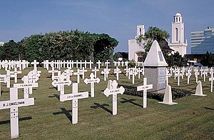
Menteng Pulo War Cemetery
Dutch war cemetery in Jakarta, Indonesia
Distance: Approx. 1681 meters
Latitude and longitude: -6.2223345,106.8394822
Menteng Pulo War Cemetery, also Dutch Field of Honor Menteng Pulo (Dutch: Nederlands Ereveld Menteng Pulo, Indonesian: Makam Kehormatan Belanda di Menteng Pulo), is a war cemetery at Jl. Menteng Pulo RT. 3 RW. 12, Menteng Dalam, Tebet, Jakarta in Indonesia. It is one of two Dutch war cemeteries in Jakarta, the other one is Ancol War Cemetery at Ancol.

Tebet Eco Park
Urban park in Tebet, Jakarta, Indonesia
Distance: Approx. 1630 meters
Latitude and longitude: -6.237329,106.852728
The Tebet Eco Park (Indonesian: Taman Eco Tebet) or Taman Kota Tebet is an urban park located in Tebet, Jakarta, Indonesia. The park has a land area of 7 hectares and it was previously known as Tebet Honda Park. It is a popular place for exercise, socialization, and recreation for neighboring community.
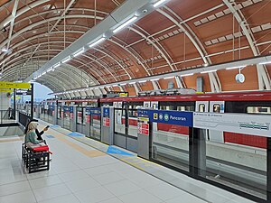
Pancoran Bank BJB LRT Station
LRT station in Indonesia
Distance: Approx. 533 meters
Latitude and longitude: -6.24212721,106.8384693
Pancoran LRT Station (or Pancoran Bank BJB LRT Station, with Bank BJB granted for naming rights) is a light rail station located in Jalan Gatot Subroto, Pancoran, Pancoran, South Jakarta. The station, which is located at an altitude of +38.510 meters, serves the Cibubur and Bekasi lines of the Jabodebek LRT system.
Weather in this IP's area
few clouds
35 Celsius
38 Celsius
34 Celsius
36 Celsius
1008 hPa
42 %
1008 hPa
1006 hPa
7000 meters
5.14 m/s
270 degree
20 %
05:29:17
17:45:15