Country:
 Indonesia
Region:
City:
Latitude and Longitude:
Time Zone:
Postal Code:
IP information under different IP Channel
ip-api
Country
Region
City
ASN
Time Zone
ISP
Blacklist
Proxy
Latitude
Longitude
Postal
Route
IPinfo
Country
Region
City
ASN
Time Zone
ISP
Blacklist
Proxy
Latitude
Longitude
Postal
Route
MaxMind
Country
Region
City
ASN
Time Zone
ISP
Blacklist
Proxy
Latitude
Longitude
Postal
Route
Luminati
Country
IDASN
Time Zone
Asia/Jakarta
ISP
PT Parsaoran Global Datatrans
Latitude
Longitude
Postal
db-ip
Country
Region
City
ASN
Time Zone
ISP
Blacklist
Proxy
Latitude
Longitude
Postal
Route
ipdata
Country
Region
City
ASN
Time Zone
ISP
Blacklist
Proxy
Latitude
Longitude
Postal
Route
Popular places and events near this IP address

Tanjung Priok
District in North Jakarta, Indonesia
Distance: Approx. 3119 meters
Latitude and longitude: -6.13333333,106.9
Tanjung Priok is a district in the administrative city of North Jakarta, Indonesia. It hosts the western part of the city's main harbor, the Port of Tanjung Priok (located in Tanjung Priok District and Koja District). The district of Tanjung Priok is bounded by Laksamana Yos Sudarso Tollway and Sunter River canal to the east, by Kali Japat, Kali Ancol, and the former Kemayoran Airport to the southwest, by Sunter Jaya Road and Sunter Kemayoran Road to the south, and by Jakarta Bay to the north.

Mal Artha Gading
Shopping mall in North Jakarta, Indonesia
Distance: Approx. 3929 meters
Latitude and longitude: -6.145576,106.892239
Mal Artha Gading is a shopping mall located in Kelapa Gading, North Jakarta, Indonesia. It has an area of 270,000 m2 (2,900,000 sq ft). The architecture was adopted from silk road and consists of types from seven wonders of the world.
Port of Tanjung Priok
Port in Indonesia
Distance: Approx. 999 meters
Latitude and longitude: -6.104,106.8865
Port of Tanjung Priok is the busiest and most advanced seaport in Indonesia, handling more than 50% of Indonesia's trans-shipment cargo traffic. The port is located at Tanjung Priok, North Jakarta, which is operated by Indonesian state owned PT Pelindo. The port has 20 terminals for accommodating general cargo, liquid bulk, dry bulk, containers, etc.
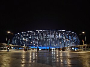
Jakarta International Stadium
Indonesian international stadium
Distance: Approx. 2853 meters
Latitude and longitude: -6.12530556,106.86011111
Jakarta International Stadium (Indonesian: Stadion Internasional Jakarta) is a retractable roof football stadium in Tanjung Priok, Jakarta, Indonesia. It is the home ground of Persija Jakarta after moving from their previous stadium, Gelora Bung Karno Stadium, and the occasional home of the Indonesia national football team, after an agreement between PSSI and PT JAKPRO to use the facility. The stadium has a seating capacity of 82,000 spectators, making it the largest stadium in Indonesia and largest football-specific stadium in Asia.

Vihara Bahtera Bhakti
Distance: Approx. 3253 meters
Latitude and longitude: -6.120324,106.853891
Vihara Bahtera Bhakti (Chinese: 安卒大伯公廟 ) is a Taoist temple located in Jakarta, Indonesia. The Chinese shrine, or klenteng, is located in the neighborhood of Ancol, hence it is more popularly known as Klenteng Ancol. It is dedicated to Da Bo Gong, a deity of land and wealth, and his wife.
Tanjung Priok railway station
Railway station in Indonesia
Distance: Approx. 153 meters
Latitude and longitude: -6.1111,106.8808
Tanjung Priok Station (TPK) is a railway station in Tanjung Priok, Tanjung Priok, North Jakarta. It is located across the Tanjung Priok Port, which is the main port of Jakarta. This station is one of the oldest in Jakarta and the biggest station built during the Dutch East Indies era.

Sunter River
River in Jakarta, Indonesia
Distance: Approx. 2770 meters
Latitude and longitude: -6.1078,106.9067
The Sunter River or Kali Sunter is a river that flows in the eastern part of Jakarta, Indonesia. The river is about 37 km long and has 73,184,092 m2 of river basin. Neighborhoods along the Kali Sunter are very densely populated and prone to frequent flooding.

Jakarta Islamic Centre
Islamic studies & research centre
Distance: Approx. 4086 meters
Latitude and longitude: -6.122601,106.917278
Jakarta Islamic Centre (JIC) is a center for Islamic studies and research in Koja, Jakarta, Indonesia. Activities of JIC include ZISWAF empowerment, education (TPA, Madrasah, Community Learning Center), socio-economic activities (mosque cooperatives), regular recitations, Tabligh Akbar, and celebrations of Islamic holidays.
Sunter, Jakarta
Distance: Approx. 3564 meters
Latitude and longitude: -6.136937,106.862089
Sunter is a neighborhood in North Jakarta, Indonesia. The neighborhood corresponds roughly with the Sunter Agung and Sunter Jaya administrative village (Indonesian: kelurahan, desa) of Tanjung Priok subdistrict of North Jakarta. Zip code of the area is 14350.

Jakarta International e-Prix Circuit
Race track in Jakarta, Indonesia
Distance: Approx. 2678 meters
Latitude and longitude: -6.11833333,106.85872222
The Jakarta International e-Prix Circuit is a 2.370 km (1.473 mi) racing circuit in Ancol, Jakarta. It was built for the Jakarta ePrix of the single-seater, electrically powered Formula E championship. The first edition of Jakarta ePrix was held here in 2022.
2023 Plumpang oil depot fire
2023 fire in Jakarta, Indonesia
Distance: Approx. 3000 meters
Latitude and longitude: -6.13444444,106.89666667
On 3 March 2023, a fire followed by an explosion occurred at a Pertamina oil depot in Plumpang, Koja, Jakarta. The fire spread to nearby residential areas, and at least thirty three people were killed.

Ancol War Cemetery
Dutch war cemetery in Jakarta, Indonesia
Distance: Approx. 3105 meters
Latitude and longitude: -6.118537,106.854787
Ancol War Cemetery, also Dutch Field of Honor Ancol (Dutch: Nederlands Ereveld Ancol, Indonesian: Makam Kehormatan Belanda di Ancol), is a war cemetery in Ancol, Jakarta, in Indonesia. It is one of two Dutch war cemeteries in Jakarta, the other being Menteng Pulo War Cemetery in Tebet. The cemetery was inaugurated on 14 September 1946.
Weather in this IP's area
few clouds
30 Celsius
31 Celsius
29 Celsius
30 Celsius
1011 hPa
51 %
1011 hPa
1011 hPa
7000 meters
5.14 m/s
270 degree
20 %
05:29:12
17:44:59