Country:
Region:
City:
Latitude and Longitude:
Time Zone:
Postal Code:
IP information under different IP Channel
ip-api
Country
Region
City
ASN
Time Zone
ISP
Blacklist
Proxy
Latitude
Longitude
Postal
Route
IPinfo
Country
Region
City
ASN
Time Zone
ISP
Blacklist
Proxy
Latitude
Longitude
Postal
Route
MaxMind
Country
Region
City
ASN
Time Zone
ISP
Blacklist
Proxy
Latitude
Longitude
Postal
Route
Luminati
Country
ASN
Time Zone
Asia/Jakarta
ISP
PT Parsaoran Global Datatrans
Latitude
Longitude
Postal
db-ip
Country
Region
City
ASN
Time Zone
ISP
Blacklist
Proxy
Latitude
Longitude
Postal
Route
ipdata
Country
Region
City
ASN
Time Zone
ISP
Blacklist
Proxy
Latitude
Longitude
Postal
Route
Popular places and events near this IP address
Graha Pena
Office in Surabaya , Indonesia
Distance: Approx. 2156 meters
Latitude and longitude: -7.32,112.731388
Graha Pena is a skyscraper building in Surabaya. It is one of the tallest buildings and is located at the south part of Surabaya. It has a height of 175 m.
Gelora Brawijaya Stadium
Stadium in Surabaya, East Java, Indonesia
Distance: Approx. 3039 meters
Latitude and longitude: -7.29611111,112.72888889
Gelora Brawijaya Stadium is a stadium in Surabaya. It was the home base of Persebaya Surabaya, until the opening of Gelora 10 November Stadium which had more capacity and modern in functionity.

DBL Arena
Indoor sporting arena
Distance: Approx. 2252 meters
Latitude and longitude: -7.3205,112.7322
The DBL Arena is an indoor sporting arena located in Surabaya, East Java, Indonesia. Located in the suburb of Surabaya, adjacent to the Graha Pena Building, it is renowned as one of the Indonesia's main venue for basketball matches. It is also home for the Development Basketball League, a basketball competition between junior and senior high schools formerly named DetEksi Basketball League (DBL).
Nahdlatul Ulama Museum
History and culture museum in Surabaya, Indonesia
Distance: Approx. 2633 meters
Latitude and longitude: -7.33822222,112.72380556
The Nahdlatul Ulama Museum (Indonesian: Museum Nahdlatul Ulama) is an Indonesian museum that documents the culture and history of the Nahdatul Ulama (NU). Opened on 25 November 2004 by Abdurrahman Wahid, the museum is located in Surabaya, Indonesia. The NU Congress inaugurated the museum with the help of Ra'is Aam as Chairman of NU and KH. M. Sahal Mahfudh.

Wonokromo
District in East Java, Indonesia
Distance: Approx. 3415 meters
Latitude and longitude: -7.30032,112.737509
Wonokromo is an administrative district (kecamatan) in the city of Surabaya, Indonesia. The Wonokromo railway station serves the area. The Kalimas River originally turned north and empties into the Tanjung Perak and Kali Jagir, a manmade branch of the river that connects east to the sea and includes a dam built by the Dutch.

Al-Akbar Mosque
Mosque in Surabaya, East Java, Indonesia
Distance: Approx. 2131 meters
Latitude and longitude: -7.336543,112.715243
Al-Akbar National Mosque of Surabaya (Indonesian: Masjid Nasional Al-Akbar Surabaya), also known as Al-Akbar Mosque (Indonesian: Masjid Al-Akbar, lit. 'Great Mosque'; Arabic: المسجد الأكبر; Javanese: ꦩꦼꦱ꧀ꦗꦶꦢ꧀ꦄꦭ꧀ꦄꦏ꧀ꦧꦂ) or Great Mosque of Surabaya, is a national mosque located in Surabaya, East Java. It is the second largest mosque in Indonesia after the Istiqlal Mosque in Jakarta in terms of maximum capacity. The location of the mosque is beside the Surabaya-Gempol Highway.

Ciputra World Surabaya
Shopping mall in Surabaya, Indonesia
Distance: Approx. 2915 meters
Latitude and longitude: -7.29263,112.719723
Ciputra World Surabaya (Mall) is a mall in Surabaya, Indonesia. Officially opened on 22 July 2011, it is located in a super-block in Southwest Surabaya along Maj. Gen.
Sunan Ampel State Islamic University Surabaya
State Islamic university in Surabaya, East Java, Indonesia
Distance: Approx. 2511 meters
Latitude and longitude: -7.32233,112.734251
Sunan Ampel State Islamic University Surabaya, also abbreviated as UIN Sunan Ampel (formerly IAIN Sunan Ampel), is one of the state Islamic universities in Indonesia based in Surabaya which organizes multidisciplinary Islamic education as well as secular education including science and technology. The university has history of cultivating the intellectual background for Islamic movements and organizations, especially for Nahdlatul Ulama. UIN Surabaya is named after Sunan Ampel, one of Wali Sanga, the legendary Sufi figures who greatly contributed to the spread of Islam in Indonesia.

My Kopi-O!
Indonesian coffee company
Distance: Approx. 3292 meters
Latitude and longitude: -7.294426,112.730427
My Kopi-O! is an Indonesian coffee company and coffeehouse chain based in Surabaya, East Java. My Kopi-O!

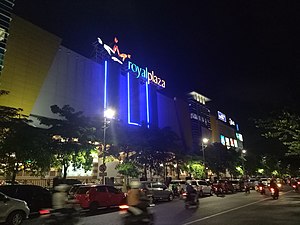
Royal Plaza (Surabaya)
Shopping mall in Surabaya, Indonesia
Distance: Approx. 2653 meters
Latitude and longitude: -7.3091953,112.7344606
Royal Plaza is a shopping center located in Surabaya, East Java. The shopping mall was founded on October 7, 2006. The mall consists of 4 floors with notable tenants namely Matahari Dept.

Kertomenanggal railway station
Railway station in Indonesia
Distance: Approx. 3200 meters
Latitude and longitude: -7.340578,112.729508
Kertomenanggal Station (KTL) is an inactive railway station located in Menanggal, Gayungan, Surabaya. This station is included in the Operation Area VIII Surabaya and is a railway station that is located in the southernmost city of Surabaya. This station is 1.2 km (0.75 mi) from Waru Station to the north, to be precise near the Surabaya Golkar Building.

Jemursari railway station
Railway station in Indonesia
Distance: Approx. 2469 meters
Latitude and longitude: -7.32937,112.731
Jemursari Station (JMS) is an inactive railway station located on the border of Jemur Wonosari and Gayungan. This station was included in the Operation Area VIII Surabaya, to be precise 3 kilometres (1.9 mi) from Wonokromo Station to the south and 2.5 kilometres (1.6 mi) from Waru Station to the north. Jemursari Station was one of the first railway stations in the city of Surabaya which was built in 2003–2004 during the launch of the Delta Ekspres service for the Surabaya–Sidoarjo connection.
Weather in this IP's area
light rain
37 Celsius
41 Celsius
34 Celsius
37 Celsius
1010 hPa
41 %
1010 hPa
1010 hPa
10000 meters
4.12 m/s
70 degree
20 %
05:04:59
17:22:34