Country:
 Indonesia
Region:
City:
Latitude and Longitude:
Time Zone:
Postal Code:
IP information under different IP Channel
ip-api
Country
Region
City
ASN
Time Zone
ISP
Blacklist
Proxy
Latitude
Longitude
Postal
Route
IPinfo
Country
Region
City
ASN
Time Zone
ISP
Blacklist
Proxy
Latitude
Longitude
Postal
Route
MaxMind
Country
Region
City
ASN
Time Zone
ISP
Blacklist
Proxy
Latitude
Longitude
Postal
Route
Luminati
Country
IDASN
Time Zone
Asia/Jakarta
ISP
PT Parsaoran Global Datatrans
Latitude
Longitude
Postal
db-ip
Country
Region
City
ASN
Time Zone
ISP
Blacklist
Proxy
Latitude
Longitude
Postal
Route
ipdata
Country
Region
City
ASN
Time Zone
ISP
Blacklist
Proxy
Latitude
Longitude
Postal
Route
Popular places and events near this IP address
International Design School
Higher education institution based in Jakarta, Indonesia
Distance: Approx. 1593 meters
Latitude and longitude: -6.213898,106.834788
IDS | BTEC is a higher education institution based in Jakarta, Indonesia, with its campus at Kemang, Jakarta. IDS was founded by Andi S. Boediman in 2000, as Digital Studio College. In 2010, the school was renamed IDS | International Design School, and in February 2024 the school was renamed IDS | BTEC. IDS | BTEC, established in 2000 in Jakarta, is an educational institution specializing in visual communication encompassing design, animation, and film & media production.
Soemantri Brodjonegoro Stadium
Multi-use stadium in South Jakarta, Indonesia
Distance: Approx. 1369 meters
Latitude and longitude: -6.221405,106.834632
Sumantri Brojonegoro Stadium (Indonesian: Stadion Soemantri Brodjonegoro) is a multi-use stadium in South Jakarta, DKI Jakarta, Indonesia. It is currently used mostly for football matches and is used as the home stadium for PSJS South Jakarta. The stadium has a capacity of 5,000 people.

Manggarai railway station
Railway station in Indonesia
Distance: Approx. 1337 meters
Latitude and longitude: -6.2099,106.8502
Manggarai Station (MRI) is a railway station at Manggarai, Tebet, South Jakarta, Jakarta, Indonesia. At present, it serves primarily as a transit station for KRL Commuterline's Bogor Line, Cikarang Loop Line, and Soekarno–Hatta Airport Rail Link; The Bukit Duri depot is located at the south side of the station, it also serves as a storage for intercity trains before they go to Gambir or Jakarta Kota stations for their departure. Currently, the station is undergoing development and will feature three levels.

Bakrie University
Private university in Jakarta, Indonesia
Distance: Approx. 1497 meters
Latitude and longitude: -6.2215,106.83347222
Bakrie University (Indonesian: Universitas Bakrie or informally U-Bakrie) is a private university in Jakarta, Indonesia, founded in 2009. It is located in Rasuna Epicentrum Jl. HR Rasuna Said Kav C-22, Kuningan, South Jakarta.

Gama Tower
Skyscraper in Jakarta, Indonesia
Distance: Approx. 1498 meters
Latitude and longitude: -6.224153,106.833731
Gama Tower (formerly known as Cemindo Tower) is a skyscraper located at Jalan H.R. Rasuna Said, South Jakarta, Indonesia. It was also known as Rasuna Tower and Cemindo Tower during construction period, but finally named as Gama Tower. As of 2022, it is the 3rd tallest building in Jakarta, as well as Indonesia.

Embassy of the United Kingdom, Jakarta
Diplomatic mission
Distance: Approx. 1732 meters
Latitude and longitude: -6.2307739,106.8344457
The Embassy of the United Kingdom in Jakarta is the chief diplomatic mission of the United Kingdom in Indonesia.
2017 Jakarta bombings
Terrorist attacks in Jakarta, Indonesia
Distance: Approx. 1037 meters
Latitude and longitude: -6.22932222,106.85205
On 24 May 2017, two explosions occurred at a bus terminal in Kampung Melayu, East Jakarta. Police confirmed that the explosions were caused by multiple explosive devices found in the toilet and in another part of the terminal. The bombings killed five people: three policemen and two attackers.

Kota Kasablanka
Shopping mall in Jakarta, Indonesia
Distance: Approx. 531 meters
Latitude and longitude: -6.223576,106.842685
Kota Kasablanka is a mixed-development covering an area of 11.5 hectares (28 acres) at Tebet in Jakarta, Indonesia, which consists of office tower, serviced office suites, shopping center, convention hall and condominium towers. This super-block is developed by PT Pakuwon Jati Tbk (PWON). CasaGrande Residence is the apartment block which has four towers, each has 36 floors namely Mirage, Avalon, Montreal and Montana.

Baru Barat River
River in Jakarta, Indonesia
Distance: Approx. 1519 meters
Latitude and longitude: -6.2347,106.8436
The Baru Barat River (Indonesian: Kali Baru Barat, lit. 'Western New River') is a man-made canal flowing from the Cisadane River in Bogor Regency to Jakarta, Indonesia. It was one of two canals built in the 18th century under the order of the Governor-General Gustaaf Willem van Imhoff, the other being the Baru Timur River (Indonesian: Kali Baru Timur, lit. 'Eastern New River'). Both canals were originally built to transport agricultural harvests from Bogor to Batavia (now Jakarta).

Trinity Tower
Skyscraper in Jakarta, Indonesia
Distance: Approx. 1536 meters
Latitude and longitude: -6.2247,106.8335
Trinity Tower is a skyscraper situated at the intersection of H.R. Rasuna Said Road and Jl. Prof. Dr.
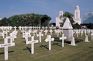
Menteng Pulo War Cemetery
Dutch war cemetery in Jakarta, Indonesia
Distance: Approx. 837 meters
Latitude and longitude: -6.2223345,106.8394822
Menteng Pulo War Cemetery, also Dutch Field of Honor Menteng Pulo (Dutch: Nederlands Ereveld Menteng Pulo, Indonesian: Makam Kehormatan Belanda di Menteng Pulo), is a war cemetery at Jl. Menteng Pulo RT. 3 RW. 12, Menteng Dalam, Tebet, Jakarta in Indonesia. It is one of two Dutch war cemeteries in Jakarta, the other one is Ancol War Cemetery at Ancol.

Matraman railway station
Railway station in Indonesia
Distance: Approx. 1785 meters
Latitude and longitude: -6.2124,106.8603
The Matraman Station (MTR) is the KRL Commuterline train station located on the border between Kebon Manggis, Matraman and Kampung Melayu, Jatinegara, East Jakarta, Indonesia. This station is adjacent to the Gunung Antang localization area and was built as the part of the Manggarai–Cikarang doubled-double track project.
Weather in this IP's area
few clouds
35 Celsius
37 Celsius
34 Celsius
35 Celsius
1009 hPa
40 %
1009 hPa
1008 hPa
7000 meters
3.09 m/s
270 degree
20 %
05:29:15
17:45:13