156.67.196.208 - IP Lookup: Free IP Address Lookup, Postal Code Lookup, IP Location Lookup, IP ASN, Public IP
Country:
 Austria
Region:
City:
Location:
Time Zone:
Postal Code:
ISP:
ASN:
language:
User-Agent:
Proxy IP:
Blacklist:
IP information under different IP Channel
ip-api
Country
Region
City
ASN
Time Zone
ISP
Blacklist
Proxy
Latitude
Longitude
Postal
Route
db-ip
Country
Region
City
ASN
Time Zone
ISP
Blacklist
Proxy
Latitude
Longitude
Postal
Route
IPinfo
Country
Region
City
ASN
Time Zone
ISP
Blacklist
Proxy
Latitude
Longitude
Postal
Route
IP2Location
156.67.196.208Country
atRegion
tirol
City
wattens
Time Zone
Europe/Vienna
ISP
Language
User-Agent
Latitude
Longitude
Postal
ipdata
Country
Region
City
ASN
Time Zone
ISP
Blacklist
Proxy
Latitude
Longitude
Postal
Route
Popular places and events near this IP address

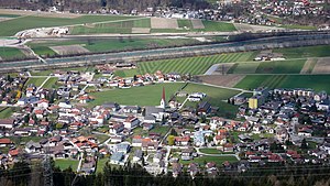
Wattens
Municipality in Tyrol, Austria
Distance: Approx. 4 meters
Latitude and longitude: 47.28333333,11.58333333
Wattens is a market town of the Innsbruck-Land District in the Austrian state of Tyrol. It is chiefly known as home of the Swarovski crystal glass company.

Wattenbach (Inn)
River in Tyrol, Austria
Distance: Approx. 2028 meters
Latitude and longitude: 47.3006,11.5917
The Wattenbach or Wattenerbach is a river of Tyrol, Austria, a tributary of the Inn. The Wattenbach has its origin in the Tux Prealps. The rivers Mölsbach and Lizumbach merge in the valley bottom near Lager Walchen at a height of 1,410 m (AA) thus forming the origin of the Wattenbach.

Weißenbach (Inn)
River in Tyrol, Austria
Distance: Approx. 4186 meters
Latitude and longitude: 47.2786,11.5283
The Weißenbach is a river of Tyrol, Austria, a tributary of the Inn. The Weißenbach rises in the valley Halltal and flows near Absam from Gnadenwald to the south to the village of Mils, which is located 12 km (7.5 mi) east of Innsbruck. In Mils just after the Lower Inn Valley Railway bridge it discharges into the Inn.

Baumkirchen
Municipality in Tyrol, Austria
Distance: Approx. 3109 meters
Latitude and longitude: 47.29972222,11.55
Baumkirchen is a community in the district of Innsbruck Land. It lies in the Inn Valley north of the Inn River on a batter of the Gnadenwald terrace. The village can be reached via the Inn Valley Motorway.

Fritzens
Municipality in Tyrol, Austria
Distance: Approx. 2503 meters
Latitude and longitude: 47.30527778,11.59027778
Fritzens is a municipality in the district Innsbruck country in Tyrol (Austria). It lies 16 km east of Innsbruck on the left side of the Inn River. The Iron Age Fritzens-Sanzeno culture is named for archaeological finds from the village.

Kolsass
Municipality in Tyrol, Austria
Distance: Approx. 4056 meters
Latitude and longitude: 47.30027778,11.63083333
Kolsass is a municipality in the district Innsbruck-Land in the Austrian state of Tyrol located about 17 km east of Innsbruck. The location was first mentioned as „Quolesazz or Cholsasz" in 1050.

Wattenberg, Tyrol
Municipality in Tyrol, Austria
Distance: Approx. 2032 meters
Latitude and longitude: 47.27333333,11.60583333
Wattenberg is a municipality in the district of Innsbruck-Land in the Austrian state of Tyrol located 15 km east of Innsbruck and 2.50 km above the Swarovski crystal town Wattens.
Volders
Municipality in Tyrol, Austria
Distance: Approx. 1439 meters
Latitude and longitude: 47.2875,11.56527778
Volders is a municipality in the district of Innsbruck-Land in the Austrian state of Tyrol located 12 km east of Innsbruck on the southern side of the Inn River.

Mils, Tyrol
Municipality in Tyrol, Austria
Distance: Approx. 4290 meters
Latitude and longitude: 47.28638889,11.52666667
Mils is a municipality in the district Innsbruck-Land of Tyrol, Austria. It is located 12 km east of Innsbruck. The area is restricted by the Weißenbach in the west and the Inn in the south.

Innsbruck bypass
Key rail transport link in western Austria
Distance: Approx. 3169 meters
Latitude and longitude: 47.28194444,11.54138889
The Innsbruck bypass (German: Umfahrung Innsbruck or sometimes Güterzugumfahrung Innsbruck, that is the Innsbruck freight railway bypass) is a 14.853-kilometre (9.229 mi)-long double-track electrified main line of the Austrian railways. It connects the Lower Inn Valley railway with the Brenner railway, bypassing Innsbruck. It was opened on 29 May 1994.

Swarovski Kristallwelten
Museum in Austria
Distance: Approx. 1772 meters
Latitude and longitude: 47.2939,11.6008
Swarovski Kristallwelten (Crystal Worlds) is an experience attraction created by André Heller for the crystal glass manufacturer Swarovski, consisting of a park, art museum, retail area, and restaurant. It opened in 1995 and is located in the Austrian Tyrol, in the town of Wattens, Innsbruck-Land District, where the company was founded and still has its headquarters today.

Fallbach (Inn, Baumkirchen)
River in Tyrol, Austria
Distance: Approx. 1993 meters
Latitude and longitude: 47.297,11.5663
Fallbach is a river of Tyrol, Austria, a left tributary of the Inn at Baumkirchen. It should not be confused with the similarly named river, a left Inn tributary in Innsbruck. The source of the Fallbach is north of Absam in the Gleirsch-Halltal Chain.
Weather in this IP's area
scattered clouds
3 Celsius
2 Celsius
1 Celsius
4 Celsius
1027 hPa
88 %
1027 hPa
863 hPa
10000 meters
1.34 m/s
2.68 m/s
270 degree
40 %