Country:
Region:
City:
Latitude and Longitude:
Time Zone:
Postal Code:
IP information under different IP Channel
ip-api
Country
Region
City
ASN
Time Zone
ISP
Blacklist
Proxy
Latitude
Longitude
Postal
Route
Luminati
Country
Region
on
City
sarnia
ASN
Time Zone
America/Toronto
ISP
PETRO-CANADA-GLOBAL-AS
Latitude
Longitude
Postal
IPinfo
Country
Region
City
ASN
Time Zone
ISP
Blacklist
Proxy
Latitude
Longitude
Postal
Route
db-ip
Country
Region
City
ASN
Time Zone
ISP
Blacklist
Proxy
Latitude
Longitude
Postal
Route
ipdata
Country
Region
City
ASN
Time Zone
ISP
Blacklist
Proxy
Latitude
Longitude
Postal
Route
Popular places and events near this IP address
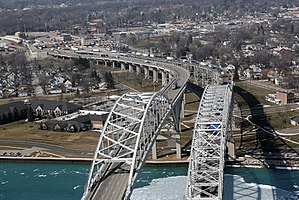
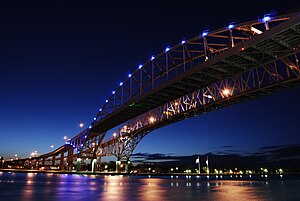
Blue Water Bridge
Twin-span bridge between Point Edward, Ontario, Canada and Port Huron, Michigan, US
Distance: Approx. 2110 meters
Latitude and longitude: 42.99861111,-82.42361111
The Blue Water Bridge is a twin-span international bridge across the St. Clair River that links Port Huron, Michigan, United States, and Point Edward, Ontario, Canada. The Blue Water Bridge connects Highway 402 in Ontario with both Interstate 69 (I-69) and Interstate 94 (I-94) in Michigan.
Point Edward, Ontario
Village in Ontario, Canada
Distance: Approx. 1454 meters
Latitude and longitude: 42.99305556,-82.40833333
Point Edward is a village in the Canadian province of Ontario. Adjacent to the city of Sarnia in Lambton County, Point Edward sits opposite Port Huron, Michigan and is connected to it by the Blue Water Bridge, at the meeting point of the St. Clair River and Lake Huron.

Thomas Edison Depot Museum
United States historic place
Distance: Approx. 2306 meters
Latitude and longitude: 42.99861111,-82.42611111
The Thomas Edison Depot Museum (previously the Grand Trunk Western Railroad Depot) is a former railway depot located at 520 State Street in Port Huron, Michigan. It has been converted into a museum. The building was listed on the National Register of Historic Places in 1977.

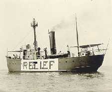
United States lightship Huron (LV-103)
1920 lightvessel, now a museum ship in Port Huron, Michigan, United States
Distance: Approx. 2813 meters
Latitude and longitude: 42.98916667,-82.42666667
The United States lightship Huron (LV-103) is a lightvessel that was launched in 1920. She is now a museum ship moored in Pine Grove Park, Port Huron, St. Clair County, Michigan.

Fort Gratiot
United States historic place
Distance: Approx. 2588 meters
Latitude and longitude: 42.995,-82.42805556
Fort Gratiot was an American stockade fort in Fort Gratiot, Michigan, in Saint Clair County, Michigan. The former location of the fort was listed on the National Register of Historic Places in 1980.
École secondaire Franco-Jeunesse
High school in Sarnia, Ontario, Canada
Distance: Approx. 2104 meters
Latitude and longitude: 42.9971,-82.3748
École secondaire Franco-Jeunesse is a French high school in Sarnia, Ontario, Canada and is administered by the Conseil scolaire Viamonde. Franco-Jeunesse opened up a new school as of September 2012. The school was previously conjoined with NCIVS, but now neighbours SFX and the French community centre.

Fort Gratiot Light
Lighthouse in Michigan, United States
Distance: Approx. 1943 meters
Latitude and longitude: 43.00630556,-82.42247222
Fort Gratiot Light , the first lighthouse in the state of Michigan, was constructed north of Fort Gratiot in 1825 by Lucius Lyon, who later became one of Michigan's first U.S. Senators. The Fort Gratiot Light marks the entrance to the St. Clair River from Lake Huron (going south) in the southern portion of Michigan's Thumb.

Fort St. Joseph (Port Huron)
Distance: Approx. 2355 meters
Latitude and longitude: 43.00193,-82.42758
Fort St. Joseph was a fort established in 1686 by Daniel Greysolon, Sieur du Lhut for New France. Erected on the St.

Lakeview cemetery, Sarnia
Cemetery in Ontario, Canada
Distance: Approx. 1523 meters
Latitude and longitude: 42.9952,-82.3846
Lakeview Cemetery Company is a cemetery located at Colborne Road and Michigan Avenue in Sarnia, Ontario. Opened in 1879 by the Town of Sarnia to replace smaller and church-based cemeteries, it is most notable for being the burial place of Canadian Prime Minister Alexander Mackenzie.
Bluewater Health
Hospital in Ontario, Canada
Distance: Approx. 3117 meters
Latitude and longitude: 42.976802,-82.390299
Bluewater Health is a hospital in Sarnia, Ontario. It was opened October 3, 1896 as Sarnia General Hospital and was the community's first public hospital. In 2010, with extensive renovations to the two existing buildings and construction of a third, it was renamed Bluewater Health.

Ladies of the Maccabees Building
United States historic place
Distance: Approx. 3130 meters
Latitude and longitude: 42.98333333,-82.42472222
The Ladies of the Maccabees Building is a fraternal organization building, located at 901 Huron Avenue in Port Huron, Michigan. It was listed on the National Register of Historic Places in 1982.

Port Huron–Sarnia Border Crossing
Canada–United States border crossing
Distance: Approx. 2096 meters
Latitude and longitude: 42.9987,-82.42347
The Port Huron–Sarnia Border Crossing connects the cities of Port Huron, Michigan and Sarnia, Ontario. It is located at the Blue Water Bridge at the St. Clair River.
Weather in this IP's area
scattered clouds
11 Celsius
10 Celsius
10 Celsius
12 Celsius
1019 hPa
69 %
1019 hPa
998 hPa
10000 meters
6.17 m/s
10.29 m/s
310 degree
40 %
07:13:44
17:13:06

