156.252.12.202 - IP Lookup: Free IP Address Lookup, Postal Code Lookup, IP Location Lookup, IP ASN, Public IP
Country:
Region:
City:
Location:
Time Zone:
Postal Code:
ISP:
ASN:
language:
User-Agent:
Proxy IP:
Blacklist:
IP information under different IP Channel
ip-api
Country
Region
City
ASN
Time Zone
ISP
Blacklist
Proxy
Latitude
Longitude
Postal
Route
db-ip
Country
Region
City
ASN
Time Zone
ISP
Blacklist
Proxy
Latitude
Longitude
Postal
Route
IPinfo
Country
Region
City
ASN
Time Zone
ISP
Blacklist
Proxy
Latitude
Longitude
Postal
Route
IP2Location
156.252.12.202Country
Region
delhi
City
new delhi
Time Zone
Asia/Kolkata
ISP
Language
User-Agent
Latitude
Longitude
Postal
ipdata
Country
Region
City
ASN
Time Zone
ISP
Blacklist
Proxy
Latitude
Longitude
Postal
Route
Popular places and events near this IP address

Palika Bazaar
Neighborhood of Delhi in India
Distance: Approx. 735 meters
Latitude and longitude: 28.631,77.2186
Palika Bazaar is an underground market located between the inner and outer circle of Connaught Place, Delhi, India. It is named after Palika Bazaar of Mumbai. Palika Bazaar hosts 380 numbered shops selling a diverse range of items; however, the market is dominated by electronic items and clothing.
Connaught Place, New Delhi
Business district in Delhi, India
Distance: Approx. 524 meters
Latitude and longitude: 28.63277778,77.21972222
Connaught Place, also known as Rajiv Chowk or CP, is one of the main financial, commercial and business centres in New Delhi, Delhi, India. It houses the headquarters of several noted Indian firms and is a major shopping, nightlife, and tourist destination in New Delhi. As of July 2018, Connaught Place ranked as the ninth most expensive office location in the world, with an annual rent of $1,650 per square meter ($153 per sq ft).

Lutyens' Delhi
Area in New Delhi, Delhi, India
Distance: Approx. 45 meters
Latitude and longitude: 28.63576111,77.22445
Lutyens' Delhi is an area in New Delhi, India, named after the British architect Edwin Lutyens (1869–1944), who was entrusted with the vast majority of the architectural design and buildings of the city that subsequently emerged as New Delhi during the period of the British Raj. Lutyens' Delhi progressively developed over the period from 1912 to 1931. This also includes the Lutyens Bungalow Zone (LBZ).
A.J.K. Mass Communication Research Centre
College of mass communication in Delhi, India
Distance: Approx. 87 meters
Latitude and longitude: 28.635308,77.22496
A.J.K. Mass Communication Research Centre (AJK MCRC) is a mass communication research centre located in New Delhi, India and a constituent institute of the Jamia Millia Islamia. The full form for AJK MCRC is Anwar Jamal Kidwai Mass Communication Research Centre named after its founder Anwar Jamal Kidwai in 1982. A.J. Kidwai established the MCRC in collaboration with York University, Toronto and the Canadian International Development Agency.

New Delhi Lok Sabha constituency
Constituency
Distance: Approx. 404 meters
Latitude and longitude: 28.635,77.22
New Delhi Lok Sabha constituency is one of the 7 Lok Sabha (parliamentary) constituencies in the Indian National Capital Territory of Delhi. This constituency came into existence in 1951. It is the oldest constituency of Delhi that currently exists.

Zakir Husain Delhi College
College in Delhi, India
Distance: Approx. 757 meters
Latitude and longitude: 28.6397,77.2302
Zakir Husain Delhi College (formerly known as Zakir Husain College, Anglo Arabic College, and Delhi College), founded in 1696, is the oldest existing educational institution in India, and is a constituent college of the University of Delhi, accredited with NAAC 'A' grade. The college comprises an area of 150 acres. The college is situated in off campus of University of Delhi It has had a considerable influence on modern education as well as Urdu and Islamic learning in India, and today remains the only Delhi University college offering BA (Hons) courses in Arabic and Persian.

Rajiv Chowk metro station
Metro station in Delhi, India
Distance: Approx. 531 meters
Latitude and longitude: 28.63280556,77.21961111
The Rajiv Chowk Metro station serves as an interchange station between the Blue and Yellow Lines of the Delhi Metro. As of October 2023, it is the second busiest station on the network, with a daily ridership of approximately 216,000 passengers The station covers an area of about 39,503 square feet (3,669.9 m²). The Rajiv Chowk Metro station serves the central business district of Connaught Place, officially named Rajiv Chowk, located in the heart of Delhi.

Barakhamba Road metro station
Metro station in Delhi, India
Distance: Approx. 616 meters
Latitude and longitude: 28.62998,77.22452611
The Barakhamba Road metro station is located on the Blue Line of the Delhi Metro. It was constructed by the Shapoorji Pallonji Group. It is located on Barakhamba Road near Modern School and the Statesman House, which houses many offices, banks, the Oxford bookstore and numerous other commercial institutions.

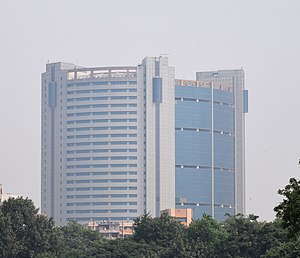
MCD Civic Centre
Tallest current building in New Delhi, India
Distance: Approx. 725 meters
Latitude and longitude: 28.6412,77.2277
Municipal Corporation of Delhi Civic Centre is the tallest building in New Delhi at 101 metres and 28 floors.

American Library (New Delhi)
Building in New Delhi, India
Distance: Approx. 745 meters
Latitude and longitude: 28.62897,77.22245
The American Library in New Delhi is a library under the supervision of the United States embassy, situated in the commercial hub of New Delhi inside the American Center (the office of US government officials in India). Opened in 1951, the Library was established to promote understanding between the people of India and the United States. The library has books on topics related to American society, American politics, American culture, and the American constitution which it serves to general public, students, teachers, and researchers.
National Institute of Disaster Management (India)
Research institution in India
Distance: Approx. 57 meters
Latitude and longitude: 28.635,77.224
National Institute of Disaster Management (NIDM) is an Indian education and research institution located in Connaught Place, New Delhi. NIDM is primarily responsible for the training and capacity development programs for managing natural disasters in India. It was constituted under an Act of Parliament in 1995; was re-designated to give the present name of National Institute of Disaster Management (NIDM) by the Disaster Management Act 2005 assented to by the President of India on 9 January 2006.
Surabhi foundation
Distance: Approx. 500 meters
Latitude and longitude: 28.63177778,77.22697222
Surabhi Foundation (abbreviated as SuFo, Hindi सुरभि) is a registered not-for-profit organisation working for improvement of socio-economic condition of farmers and artisans in rural India. SuFo works for a healthy and equitable self-reliant society. This is brought about by accomplishing rural prosperity and growth through adopting environmentally harmonious farming systems, utilizing local natural resources and availing non farming opportunities integrating indigenous and global knowledge, people-centered development and empowerment approach.
Weather in this IP's area
broken clouds
13 Celsius
12 Celsius
13 Celsius
13 Celsius
1020 hPa
44 %
1020 hPa
994 hPa
10000 meters
1.86 m/s
3.07 m/s
302 degree
71 %
