Country:
 USA
USARegion:
City:
Latitude and Longitude:
Time Zone:
Postal Code:
IP information under different IP Channel
ip-api
Country
Region
City
ASN
Time Zone
ISP
Blacklist
Proxy
Latitude
Longitude
Postal
Route
IPinfo
Country
Region
City
ASN
Time Zone
ISP
Blacklist
Proxy
Latitude
Longitude
Postal
Route
MaxMind
Country
Region
City
ASN
Time Zone
ISP
Blacklist
Proxy
Latitude
Longitude
Postal
Route
Luminati
Country
USRegion
ca
ASN
Time Zone
America/Los_Angeles
ISP
ASN-CXA-ALL-CCI-22773-RDC
Latitude
Longitude
Postal
db-ip
Country
Region
City
ASN
Time Zone
ISP
Blacklist
Proxy
Latitude
Longitude
Postal
Route
ipdata
Country
Region
City
ASN
Time Zone
ISP
Blacklist
Proxy
Latitude
Longitude
Postal
Route
Popular places and events near this IP address
Center for Individual Freedom
American policy advocacy organization
Distance: Approx. 162 meters
Latitude and longitude: 38.8054,-77.0486
The Center for Individual Freedom (CFIF) is an Alexandria, Virginia based U.S. nonprofit conservative policy advocacy organization.

Christ Church (Alexandria, Virginia)
Historic church in Virginia, United States
Distance: Approx. 176 meters
Latitude and longitude: 38.80630278,-77.04751667
Christ Church is an Episcopal church located at 118 North Washington Street, with an entrance at 141 North Columbus Street, in Alexandria, Virginia. Constructed as the main church in the Church of England's Fairfax Parish, the building was designed by Col. James Wren, a descendant of Sir Christopher Wren.
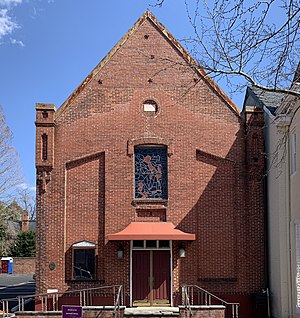
Beulah Baptist Church
Historic Baptist church in Virginia, United States
Distance: Approx. 114 meters
Latitude and longitude: 38.80388889,-77.0475
Beulah Baptist Church is a predominantly Black Baptist Church at 320 S. Washington Street in Old Town Alexandria, Virginia. The historic building is a two-story brick structure with a gable roof and large stained glass window. Built in 1863, it was sandwiched between the two Black neighborhoods of 'the Hill' and 'the Bottoms'.

Alexandria Historic District
National Historic Landmark District in Alexandria, Virginia, United States
Distance: Approx. 169 meters
Latitude and longitude: 38.80333333,-77.04638889
The Alexandria Historic District is a National Historic Landmark District in Alexandria, Virginia. Encompassing all of the city's Old Town and some adjacent areas, this area contains one of the nation's best-preserved assemblages of the late-18th and early-19th century urban architecture. The district was locally designated (as the Old and Historic Alexandria district) in 1946 and was declared a National Historic Landmark in 1966.
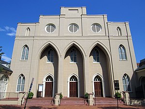
St. Paul's Episcopal Church (Alexandria, Virginia)
Historic church in Virginia, United States
Distance: Approx. 240 meters
Latitude and longitude: 38.80305556,-77.04527778
St. Paul's Episcopal Church is an historic Episcopal church in the Anglican Communion located in the Old Town area of Alexandria, Virginia. The church, consecrated in 1818, was designed by Benjamin Latrobe, the second architect of the United States Capitol.

Marshall House (Alexandria, Virginia)
Hotel in Virginia, United States
Distance: Approx. 203 meters
Latitude and longitude: 38.80469444,-77.04456944
The Marshall House was an inn that stood at 480 King Street (near the southeast corner of King Street and South Pitt Street) in Alexandria, Virginia. At the beginning of the American Civil War in 1861, the house was the site of the killing of Col. Elmer E. Ellsworth during the Union Army's takeover of Alexandria.
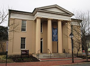
Lyceum (Alexandria, Virginia)
United States historic place
Distance: Approx. 142 meters
Latitude and longitude: 38.80361111,-77.0475
The Lyceum is a historic museum and event space in Alexandria, Virginia. Built in 1839 on the initiative of Quaker schoolmaster Benjamin Hallowell, it has been listed on the National Register of Historic Places since May 27, 1969, the year of its purchase by the city. Constructed in the then-popular Greek Revival style from bricks recycled from the original St.

Bayne–Fowle House
Historic house in Virginia, United States
Distance: Approx. 232 meters
Latitude and longitude: 38.80416667,-77.04944444
The Bayne–Fowle House is a historic house located at 811 Prince Street in Alexandria, Virginia, United States. It was added to the National Register of Historic Places on November 6, 1986. The Bayne–Fowle House is a masonry townhouse built in 1854 for William Bayne, an Alexandria-based commission merchant.

Lloyd House (Alexandria, Virginia)
Historic house in Virginia, United States
Distance: Approx. 239 meters
Latitude and longitude: 38.80694444,-77.04694444
The Lloyd House, also known as the Wise-Hooe-Lloyd House, is a historic house and library located at 220 North Washington Street at the corner of Queen Street in the Old Town area of Alexandria, Virginia. It was built from 1796 to 1797 by John Wise, a prominent entrepreneur, in the late eighteenth-century Georgian architectural style. The house was added to the National Register of Historic Places on July 12, 1976.

Appomattox (statue)
Bronze statue in Virginia, United States
Distance: Approx. 102 meters
Latitude and longitude: 38.80391667,-77.04719444
Appomattox is a bronze statue commemorating soldiers from Alexandria, Virginia, who had died while fighting for the Confederacy during the American Civil War. The memorial was located in the center of the intersection of South Washington Street (Virginia Route 400) and Prince Street in the Old Town neighborhood of Alexandria. The National Park Service placed the monument on the National Register of Historic Places during 2017.
Beulah Normal and Theological Institute
Distance: Approx. 114 meters
Latitude and longitude: 38.80388889,-77.0475
Beulah Normal and Theological Institute was the first Black school for educating teachers and preachers during the American Civil War and Reconstruction. It was founded in 1862 in Alexandria, Virginia by an African American preacher, Rev. Clem Robinson, as an upper division of "The First Select Colored School," in that city.
Alexandria Fire Department
Fire department in Alexandria, Virginia, US
Distance: Approx. 29 meters
Latitude and longitude: 38.80472222,-77.04722222
The Alexandria Fire Department (AFD) provides fire protection and emergency medical services to the city of Alexandria, Virginia. Established in 1866, the department is responsible for 15 square miles (39 km2) with a population of over 159,000.
Weather in this IP's area
broken clouds
26 Celsius
26 Celsius
25 Celsius
28 Celsius
1013 hPa
65 %
1013 hPa
1012 hPa
10000 meters
3.09 m/s
350 degree
75 %
06:53:38
19:10:05