Country:
 USA
USARegion:
City:
Latitude and Longitude:
Time Zone:
Postal Code:
IP information under different IP Channel
ip-api
Country
Region
City
ASN
Time Zone
ISP
Blacklist
Proxy
Latitude
Longitude
Postal
Route
IPinfo
Country
Region
City
ASN
Time Zone
ISP
Blacklist
Proxy
Latitude
Longitude
Postal
Route
MaxMind
Country
Region
City
ASN
Time Zone
ISP
Blacklist
Proxy
Latitude
Longitude
Postal
Route
Luminati
Country
USRegion
wa
City
cheney
ASN
Time Zone
America/Los_Angeles
ISP
UNITAS
Latitude
Longitude
Postal
db-ip
Country
Region
City
ASN
Time Zone
ISP
Blacklist
Proxy
Latitude
Longitude
Postal
Route
ipdata
Country
Region
City
ASN
Time Zone
ISP
Blacklist
Proxy
Latitude
Longitude
Postal
Route
Popular places and events near this IP address

Cheney, Washington
City in Washington, United States
Distance: Approx. 700 meters
Latitude and longitude: 47.48861111,-117.57861111
Cheney ( CHEE-nee) is a city in Spokane County, Washington, United States. The full-time resident population was 13,255 as of the 2020 census. Eastern Washington University is located in Cheney.

Eastern Washington University
Public university in Cheney, Washington, U.S.
Distance: Approx. 500 meters
Latitude and longitude: 47.49138889,-117.58305556
Eastern Washington University (EWU) is a public polytechnic university in Cheney, Washington, United States. It shares its satellite campus in Spokane, Washington with Washington State University and has partnerships with various community colleges in the state of Washington. The university primarily awards four-year degrees in vocational education and focuses on career pathways for its students.
Cheney School District
School in Washington, US
Distance: Approx. 5742 meters
Latitude and longitude: 47.541581,-117.546417
Cheney School District No. 360 is a public school district in Spokane County, Washington and serves the towns of Cheney, Airway Heights, and the surrounding area. The district offers classes from Kindergarten to Grade 12.
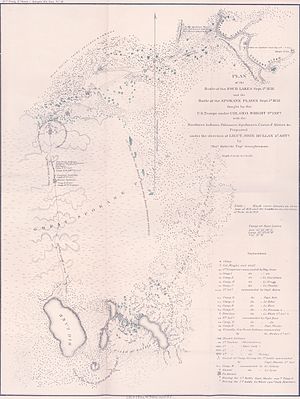
Battle of Four Lakes
Distance: Approx. 6630 meters
Latitude and longitude: 47.550664,-117.609874
The Battle of Four Lakes was a battle during the Coeur d'Alene War of 1858 in the Washington Territory (now the states of Washington and Idaho) in the United States. The Coeur d'Alene War was part of the Yakima War, which began in 1855. The battle was fought near present-day Four Lakes, Washington, between elements of the United States Army and a coalition of Native American tribes consisting of Schitsu'umsh (Coeur d'Alene), Palus, Spokan, and Yakama warriors.
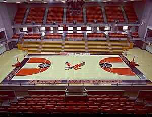
Reese Court
Distance: Approx. 867 meters
Latitude and longitude: 47.4914,-117.5892
Reese Court is a 6,000-seat multi-purpose arena in Cheney, Washington, on the campus of Eastern Washington University. It is home to the EWU Eagles basketball team and replaced Eastern Washington Fieldhouse in 1975. It was the host venue of the 2004 Big Sky Conference men's basketball tournament, and is located southwest of the football stadium, Roos Field.
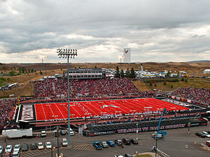
Roos Field
Outdoor college football stadium in the northwest United States
Distance: Approx. 716 meters
Latitude and longitude: 47.493,-117.588
Roos Field is an outdoor college football stadium in the northwest United States, on the campus of Eastern Washington University in Cheney, Washington, southwest of Spokane. It is the home venue of the Eastern Washington Eagles of the Big Sky Conference in Division I (FCS). Opened 57 years ago in 1967, the Eagles have accomplished a 112–51 (.687) record at home.

Four Lakes, Washington
Census-designated place in Washington, United States
Distance: Approx. 7490 meters
Latitude and longitude: 47.56138889,-117.59416667
Four Lakes is an unincorporated community and census-designated place in Spokane County, Washington, United States, just southwest of the city of Spokane, and north of Cheney. As of the 2010 census, its population was 512. Both Interstate 90 and SR 904 run through Four Lakes and the junction of the two is located near the center of town.
Washington State Digital Archives
Distance: Approx. 985 meters
Latitude and longitude: 47.488,-117.5871
The Washington State Digital Archives in Cheney, Washington preserves electronic records from Washington's state and local government agencies. It opened in October 2004 and is the first state archives in the United States dedicated specifically to the preservation of electronic records.

Cheney Odd Fellows Hall
United States historic place
Distance: Approx. 962 meters
Latitude and longitude: 47.48666667,-117.575
The Cheney Odd Fellows Hall in Cheney, Washington is a historic building that was built in 1904. It was listed on the National Register of Historic Places in 1990. It was deemed "historically significant for its association with the community's leading fraternal organization in the early 20th century and is the best preserved example of vernacular commercial architecture from the period." Its NRHP nomination describes it as having been "the venue of the community's most important social events and civic meetings.
1891 State Normal School at Cheney fire
Distance: Approx. 725 meters
Latitude and longitude: 47.490718,-117.586284
The 1891 State Normal School at Cheney fire was a conflagration on the morning of August 27, 1891, that consumed the only building then housing the State Normal School at Cheney in Cheney, Washington. There were no deaths, but the destruction of the building sparked a multi-year battle with the governor and state legislature regarding whether the normal school would be shuttered, or whether the state would authorize funds for the construction of a replacement building.
1912 State Normal School at Cheney fire
1912 school fire incident in Cheney, Washington
Distance: Approx. 533 meters
Latitude and longitude: 47.491,-117.583
The 1912 State Normal School at Cheney fire consumed the main classroom and office building of the State Normal School at Cheney, in Cheney, Washington, on April 24, 1912. There were no deaths, but the destruction of the building led to a prolonged political fight over whether the state legislature and governor would close the institution, or authorize funds for its replacement.
Cheney High School (Washington)
School in Cheney, Washington, United States
Distance: Approx. 374 meters
Latitude and longitude: 47.498,-117.577
Cheney High School is a four-year public high school in Cheney, Washington, United States serving the Cheney School District. The school has a population of 1,300 students in grades 9–12, with more than 70 full-time equivalent teaching staff. Cheney athletic teams compete in the Greater Spokane League (3A class) as the Blackhawks, and the school colors are red and black.
Weather in this IP's area
clear sky
13 Celsius
11 Celsius
12 Celsius
13 Celsius
1013 hPa
54 %
1013 hPa
929 hPa
10000 meters
06:58:15
18:17:23