Country:
 USA
USARegion:
City:
Latitude and Longitude:
Time Zone:
Postal Code:
IP information under different IP Channel
ip-api
Country
Region
City
ASN
Time Zone
ISP
Blacklist
Proxy
Latitude
Longitude
Postal
Route
IPinfo
Country
Region
City
ASN
Time Zone
ISP
Blacklist
Proxy
Latitude
Longitude
Postal
Route
MaxMind
Country
Region
City
ASN
Time Zone
ISP
Blacklist
Proxy
Latitude
Longitude
Postal
Route
Luminati
Country
USRegion
al
City
birmingham
ASN
Time Zone
America/Chicago
ISP
UNITAS
Latitude
Longitude
Postal
db-ip
Country
Region
City
ASN
Time Zone
ISP
Blacklist
Proxy
Latitude
Longitude
Postal
Route
ipdata
Country
Region
City
ASN
Time Zone
ISP
Blacklist
Proxy
Latitude
Longitude
Postal
Route
Popular places and events near this IP address

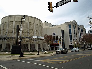
Alabama Theatre
Movie theatre in Birmingham, Alabama, USA
Distance: Approx. 570 meters
Latitude and longitude: 33.51491389,-86.80917778
The Alabama Theatre is a movie palace in Birmingham, Alabama. It was built in 1927 by Paramount's Publix Theatres chain as its flagship theater for the southeastern region of the United States. Seating 2,500 people at the time, it was the largest in the Birmingham theater district.
McWane Science Center
Science museum and research archive in Birmingham, Alabama, U.S.
Distance: Approx. 557 meters
Latitude and longitude: 33.51477,-86.808262
The McWane Science Center (formerly known as the McWane Center) is a science museum and research archive located in downtown Birmingham, Alabama, United States. The state-of-the-art hands-on science center, aquarium, and 250-seat IMAX Dome Theater is housed in the historic and refurbished Loveman's department store building. It opened to the public on July 11, 1998.

Carver Theatre (Birmingham, Alabama)
Theater in Birmingham, Alabama, US
Distance: Approx. 625 meters
Latitude and longitude: 33.514888,-86.811849
The Carver Theatre, now formally known as the Carver Performing Arts Center, is a theater located in downtown Birmingham, Alabama. In its days as a motion picture theater, it was best known as a place where African-Americans could see first-run movies; during that time, only whites were allowed in most theaters because of segregation laws. The Carver is now a live performance venue which seats 527, and is also the home of the Alabama Jazz Hall of Fame.

Heaviest Corner on Earth
United States historic place
Distance: Approx. 603 meters
Latitude and longitude: 33.514437,-86.80565
The Heaviest Corner on Earth is a promotional name given to the corner of 20th Street and 1st Avenue North in Birmingham, Alabama, United States, in the early 20th century. The name reflected the nearly simultaneous appearance of four of the tallest buildings in the South, the 10-story Woodward Building (1902), 16-story Brown Marx Building (1906), 16-story Empire Building (1909), and the 21-story American Trust and Savings Bank Building (1912). The announcement of the last building was made in the Jemison Magazine in a January 1911 article titled "Birmingham to Have the Heaviest Corner in the South".
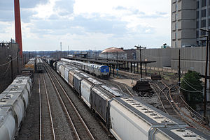
Birmingham station (Alabama)
Distance: Approx. 316 meters
Latitude and longitude: 33.51222222,-86.80722222
Birmingham station is a train station in Birmingham, Alabama. It is a service stop for Amtrak's Crescent, which provides daily service between New York City, Atlanta, and New Orleans. The current station is located on the site of another station originally built by the Louisville and Nashville Railroad in 1960, although Amtrak did not use the building itself, which was torn down in the 2000s.
Regions Field
Baseball venue in Birmingham, Alabama, U.S.
Distance: Approx. 267 meters
Latitude and longitude: 33.50763,-86.810218
Regions Field is the name of a minor league baseball park in the Southside community of Birmingham, Alabama, U.S. It is the home field for the Birmingham Barons of the Southern League, and it replaced Hoover Metropolitan Stadium in the Birmingham suburb of Hoover as their home field. It also serves as the second home field along with Jerry D. Young Memorial Field for the UAB Blazers. Regions Field is located adjacent to the Railroad Park, just south of downtown Birmingham.

Daniel Building
20-story office building located in downtown Birmingham, Alabama
Distance: Approx. 579 meters
Latitude and longitude: 33.51217,-86.80345
The Daniel Building is a 20-story, 238 foot (86 m) office building located in downtown Birmingham, Alabama. Built in 1970, the building originally served as a regional office for the engineering and construction company Daniel International. It also served as the corporate headquarters for Daniel International's real estate division, Daniel Realty, which today is known as Daniel Corporation.

John Hand Building
United States historic place
Distance: Approx. 618 meters
Latitude and longitude: 33.514347,-86.805175
John Hand Building is a mixed-use high rise building in Birmingham, Alabama, USA, with a height of 287 feet (87 m). It was the tallest building in the city until surpassed by the City Federal Building in 1913. It comprises 20 floors and was completed in 1912.

Thomas Jefferson Hotel
19-story building on the western side of downtown Birmingham, Alabama
Distance: Approx. 369 meters
Latitude and longitude: 33.5128,-86.81069
Thomas Jefferson Tower, originally the Thomas Jefferson Hotel and then the Cabana Hotel, is a 19-story building on the western side of downtown Birmingham, Alabama. It was completed in 1929 as the 350-room Thomas Jefferson Hotel and is at 1623 2nd Avenue North. It has a tower in its roof intended to be a zeppelin mooring mast.
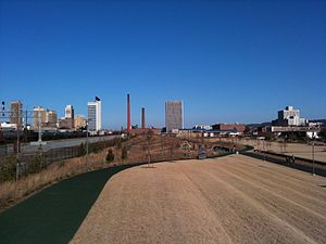
Railroad Park
Distance: Approx. 112 meters
Latitude and longitude: 33.50949167,-86.81014444
Railroad Park is a 19-acre park in Birmingham, Alabama, United States, that opened in the fall of 2010. It was designed by landscape architect Tom Leader and built by Birmingham-based Brasfield & Gorrie. The park lies immediately south of the Norfolk Southern and CSX rail lines through downtown Birmingham.

Children's of Alabama
Hospital in Alabama, United States
Distance: Approx. 543 meters
Latitude and longitude: 33.50555556,-86.80611111
Children's of Alabama is a pediatric acute care children's hospital located in Birmingham, Alabama. The main hospital has 332 beds and 48 bassinets. The hospital is affiliated with the University of Alabama at Birmingham School of Medicine.

Alabama Penny Savings Bank
United States historic place
Distance: Approx. 591 meters
Latitude and longitude: 33.515,-86.81027778
The Alabama Penny Savings Bank is a historic building built in 1913 at 310 18th Street North in Birmingham, Alabama, United States. The building has also been known as the Pythian Temple. Alabama Penny Savings Bank was the first black-owned bank in Alabama and financed construction of homes and churches for thousands of local black citizens.
Weather in this IP's area
clear sky
15 Celsius
14 Celsius
13 Celsius
16 Celsius
1017 hPa
74 %
1017 hPa
995 hPa
10000 meters
2.06 m/s
340 degree
06:26:27
19:03:23